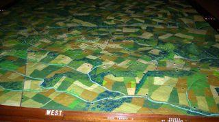
Gettysburg National Military Park is getting a new visitor center next year, and to make way for the new construction, the old center must be torn down. In the middle of the current center is a very popular exhibit called 'The Electric Map'. The map is the centerpiece of a small auditorium. The story of the battle is told with sequenced lights that appear to move around on the map. Some have said that the explanation of troop movements on the map explained the battle better than anything else. This exhibit has been around for a long time, and predates the Park Service at Gettysburg. The map was originally built sometime in the 1930s, and then went through a big overhaul in the 1960s. It had been operated privately until the National Park Service acquired everything in 1972. Up until the Park Service took over, the map was operated manually, but I've been told, that since 1972 it has been running on the same automated system. Gettysburg Ranger Eric Campbell told me that the exhibit is really loved by the public. "I'm sure the new exhibit will be great, but I'm sad to see this one go," he said.
The exhibit is so large, it is not at all easy to remove from the building. Because of the difficulty involved, there had even been talk about destroying the map along with the building. And while that may have been the last option, it stirred a lot of emotions in the Gettysburg community. In June, a citizen's group asked that the map not be destroyed, and park Superintendent John Latschar has agreed. The plan now is to cut the map into smaller pieces, apply shrink wrap, and put the pieces in storage somewhere in the park. There are no plans for the exhibit beyond that.
It is possible the map may not ever resurface, but at least this option leaves the door open for future alternatives, and doesn't destroy an exhibit that has been a visitor favorite for generations.


Comments
My Grandfather took me to see this map when I was a little boy. I learned more about Civil War history with that one visit than I did in all my years of public school. It's "disappearance" would truly be a tragic loss.
I am incredibly disappointed with the Park Service decision to discontinue the electric map presenation. In my opinion, although the program was "low tech" by today's standards. it gave the viewers a feel for the North-South-East-West of the battle field for a preliminary orientation before the actual driving (or walking tour). Add in the nostalgia factor and it was the perfect place to take visitors and students not only for the history of the battle but also for the history of the map itself.... Is there a way to petition the Park service to bring back this piece of history? I will not be taking any more visitors and friends and students to Gettysburg unless the map is reinstalled. Mourning the demise of another piece of history in its own right....The removal of the map speaks volumes about the inept management and lack of vision on the part of the Park Service. Please....
Get rid of the food court and the gift shop and make room for the map!!!!! It will be worth the effort!
AlaskaAbi
Why would the park service do away with the electric map? Such a great way for people to understand the troop movements of this historic battle. This makes no sense. Must be a decision made by people who don't have a clue and don't care what the visiting public would like to see. Shame on those who made this decision.