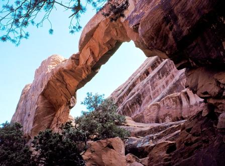
One minute it was there, the next it was gone.
The collapse of "Wall Arch" at Arches National Park proves once again that gravity does work, even though you might wonder after gazing at the "rockitecture" of this dazzling Utah park.
Wall Arch, long a key attraction along the park's Devils Garden Trail, collapsed sometime overnight August 4. And since rock has continued to peel off of the collapsed arch, officials have been forced to temporarily close the popular trail just beyond Landscape Arch.
On Thursday representatives from both the National Park Service Geologic Resources Division and the Utah Geological Survey visited the site and noted obvious stress fractures in the remaining formation. Rock debris has completely blocked this section of the trail. The closure will remain in effect until visitor safety issues can be resolved.
First reported and named by Lewis T. McKinney in 1948, Wall Arch was a free-standing arch in the Slickrock member of the Entrada sandstone. The opening beneath the span was 71-feet wide and 33-1/2 feet high. It ranked 12th in size among the over 2,000 known arches in the park.
All arches are but temporary features and all will eventually succumb to the forces of gravity and erosion. While the geologic forces that created the arches are still very much underway, in human terms it’s rare to observe such dramatic changes.
No one has reported observing the arch collapse and there were no visitor injuries.


Comments
Maybe it was only by rare chance that my husband and I--visiting Arches in May--saw a couple on top of Wall Arch. Later in the day we saw a man on top of Sand Dune Arch. The following day we saw a woman and her young daughter walk during 30 MPH wind gusts across Mesa Arch in Canyonlands, which is exposed on both sides to tremendous drop offs, so frightening to see that I had to walk away. I was so sure we were about to witness people dying that my experience was wrecked.
Or perhaps these incidents were not coincidental to our visit. Perhaps others blogging here--and park officials, even-- are naive about the audacity of visitors and the frequency with which they stand and walk on top of these fragile, beautiful arches, ignorant or inconsiderate of the harm they do. If there are rules, we saw none posted. If there are not rules and fines--heavy, steep fines--then perhaps there should be.
OK, here's a tenuously proposed triggering mechanism: the humidity was rising that night, and sandstone constitutes a semipermeable membrane. H2O molecules are lighter than N2 and O2, vibrate more rapidly, and find their way through the rock faster than dry air. This enables the rock to build up a partial pressure of water vapor faster than the total pressure of dry air in the rock can be dissipated, so that the gasseous pressure in the rock may build up a few mmHg of pressure--maybe enough to trigger a collapse. I suppose the mechanics and magnitude of such a phenomenon could be studied experimentally. --AGF
http://www.youtube.com/watch?v=MsONpZA8X3A
Two witnesses to the collapse have come forward.
AGF - I like to think that a canyon raven, a crafty bird in all environments, landed atop the arch thus providing the last few ounces of downward stress causing this immense collapse. Amidst the din and dust the raven was surprised as his footing disappeared. No problem his black wings spread, caught the breeze, and lifted him into the blue sky. Another day in slickrock country.
I recant. But it will be a few days before that raven sets down on another arch in slickrock country. --AGF
Wow, this is two McInnis Canyons NCA references on NPT in about a week - that's got to be a record! Here is one of the more notable arches in the Rattlesnake Canyon area, folks climb through it though it is not an official BLM trail.
Some more photos of the Rattlesnake Arches area of McInnis Canyons National Conservation Area are located here: http://www.flickr.com/photos/mattmcgrath/sets/72157604318334308/
Their are many arches in Arches National Park that you can walk under and a few that you actually can walk on.
It is amazing that no one was hurt when this arch fell.
The Park service needs to have engineers study the arches that are accessible to insure their safety.
This park is one of the most beautiful areas in the United States.
PS It didn't take eons to form the arches. Arches are formed all over the world over a few centuries of wind, flfash flooding rain and weathering.
The entire Colorado Basin is eroding at about the rate Lake Powell is filling up with mud, or formerly, at the rate the Bay of California was filling up--slower than Baja is pulling away. Sandstone buildings erode less than an inch per century. Rainbow Bridge had a stream that flowed around it till the hole broke through; then the stream flowed through the hole, so a narrower gulch formed within a wider gulch. Both gulches help to give us an idea of the Bridge's erosion rates. The rocks that have broken off over the tens or hundreds of thousands of years have turned back to sand, and washed into the sea. It's a pretty slow process. --AGF