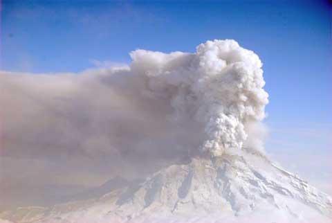
Alaska marks 50 years of statehood this year, and Mt. Redoubt, located in Lake Clark National Park and Preserve, has crashed the party with a series of impressive eruptions.
A half-century of statehood for Alaska is being marked with a commemorative license plate, stamp and quarter. Mt. Redoubt has recently gotten into the act by contributing some impressive—but unwelcome—natural fireworks.
The Alaska Volcano Observatory has reported 17 "major explosive events" at the volcano in the past ten days:
The 2009 eruption of Redoubt Volcano, which began on March 22 ... has been characterized by powerful ash explosions, with the resulting plumes reaching between 30,000 to 60,000 feet above sea level...The larger explosions have been associated with lahars [mudflows] in the Drift River Valley and trace to minor ash fall in and around the volcano and in areas across south-central Alaska.
Based on its past activity, the current Redoubt eruption is expected to continue for weeks to months. During this time, a cycle of relatively quiet periods of lava dome growth followed by explosive episodes of dome destruction could take place. Future explosions pose an ongoing threat of lahars in the Drift River Valley, trace to minor ash fall throughout south-central Alaska, and ash-related impacts to aviation.
Heavily ice-mantled Redoubt volcano is located on the western side of Cook Inlet, 106 miles southwest of Anchorage... within Lake Clark National Park. Redoubt is a stratovolcano which rises to 10,197 feet above sea level. Recent eruptions occurred in 1902, 1966-68, and 1989-90.
The 1989-90 eruption produced mudflows, or lahars, that traveled down the Drift River and partially flooded the Drift River Oil Terminal facility. The ash plumes produced by the 1989-90 eruption affected international air traffic and resulted in minor or trace amounts of ash in the city of Anchorage and other nearby communities.
The Alaska Volcano Observatory site includes a dramatic photo of lightning from Redoubt's 1:20 a.m. eruption on March 28, and a webcam view of Mt. Redoubt. Limited visibility and the still relatively short daylight period in Alaska may result in less than stunning webcam views at times.
The good news for Lake Clark National Park and Preserve is that this rugged and beautiful area has limited facilities and light visitation in the early spring season. Those factors have greatly reduced immediate risks from the eruption to both the public and the park staff. Even so, the upcoming summer season promises to be a bit more challenging than usual for the staff at Lake Clark.
Tourism is a major player in the Alaska economy, and there is some concern about how the eruption will affect travel for the coming summer. One of the potential problems is disruption of air travel by volcanic ash.
Airborne volcanic ash is very abrasive and can be damaging to everything from large jet engines to computers. Alaska Airlines is a major player in the state's travel business, and according to Associated Press reports has canceled about 150 flights affecting an estimated 10,000 passengers since the eruptions began on March 22nd.
I give Alaska Airlines good marks for being both cautious and flexible; they appear to be efficiently managing flights to the state based on day-to-day conditions, and restoring service as soon as it's prudent to do so. If you have travel plans to Alaska in coming weeks, you can check the current status of flights at the Anchorage airport on-line.
Curious where the ash from any upcoming eruptions will be carried by the wind? The National Weather Service office in Anchorage updates a prediction model every six hours, along with ash fall forecasts and lots of other weather-related information on the Redoubt eruption.
Since the impact of ash is determined by the wind direction, much of the state has been spared any direct impact from the eruptions thus far. However, if a trip to Alaska is in your plans in coming weeks, it would be prudent to check on conditions shortly before your departure. Regular, official updates are available on-line from the Alaska Volcano Observatory


Add comment