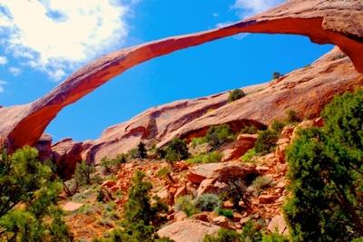
There might be no finer time to hike in Arches National Park than early mornings, when the soft light of the rising sun glints off red-rock and spindly Utah junipers and waves of sandstone fins cast long shadows.
With the soft crunch of sand under foot and the distinctive smell of the desert -- pungent sage and sweet juniper seem to dominate, though even the sandstone has an earthy aroma to it -- enveloping you, exploring the park before the day's high heat sets in doesn't get much better.
While many visitors to Arches seem perfectly satisfied to make the 30-minute walk from the Devils Garden parking area to admire Landscape Arch, and more than a few embark on 4-mile roundtrip to Double O Arch, only a handful or two endeavor to explore the 7.2-mile Primitive Loop that climbs and drops across this incredible landscape.
Perhaps the Caution, Primitive Trail, Difficult Hiking sign at the spur that wanders off from the side of Double O Arch intimidates folks. Many, no doubt, never even get to that point, as early on there's a thin rock fin that might be too much for hikers who prefer to be more grounded, as it must be traversed for maybe 75 yards while you avoid a fall far enough down to do some bodily damage.
Those who venture down the trail, though, are pulled into a landscape where Arches' renowned geology is being manufactured. Here the trail takes you past patches of prickly pear and, in season, red bursts of Indian paintbrush. You walk across thin fins of rock still being whittled into arches by erosion, down the shoulders of these fins, and through narrow passageways between the fins. At times you negotiate potholes filled from recent rains, and stroll down dusty washes, ever watchful for small cairns of rocks that slowly but surely lead you back to the main trail near Landscape Arch.
Take a chance on this trail, which can take three or more hours to negotiate depending on how much you like to dawdle, and you'll not only pass well-known arches such as Landscape, Double O, and the remains of Wall Arch, but short side trails leading to Navajo, Partition, and Private arches.
Best of all, though, you'll be pulled into the red-rock landscape, away from the crowds, and into your own private corner of Arches.
Trail: Devils Garden Primitive Loop
Trailhead: Devils Gardening parking lot
Length: 7.2 miles roundtrip
Difficulty: Moderate to strenuous, both due to heights that must be conquered and, in summer, the hot, arid climate.
Advice: Pack plenty of water, snacks, lots of sunscreen, and wear a wide-brimmed hat.
Payoff: Gorgeous landscape, solitude


Comments
I agree. I did this same hike with my wife in Oct. 2006. The best parts of this hike was when we experienced virtual solitude and sense of adventure while hiking the primitive trail back from Double 'O' Arch. When we completed our hike and returned to the car, I recall entertaining thoughts about the need for some kind of trail-head carrying capacity. All parking spaces at Devil's Garden were taken, and there were many cars parked in undesignated places.
I've been to Arches a few times but have only had about a half day to hike when I have been there. I haven't done this trail. I will have to keep it in mind the next time I go.
RIP Wall Arch.
I've hiked this loop both mid-morning and late afternoon. pkrngr is right about solitude: even though it was roasting hot in the afternoon, the out & back trail was crowded. We were alone on the primitive loop, and stopped at a couple of shaded spots to sit silently and appreciate the desert environment & sounds. When I hiked the loop in the morning, we did come across a couple of other groups on the primitive loop, but paused and explored a side trail to let them get substantial distance from us.
If you go late afternoon there's an arch you can't see up high to the west of the trail between the junction & Pine Tree Arch that puts a spot of sunlight on a fin south of the trail maybe 45 minutes to an hour before sunset.
No matter the time of day, I strongly recommend taking 4 times as much water along as you think you will want & need. I consumed 3 partially-frozen 2 liter bottles of water/gatorade hiking the loop, and it was worth the weight and full daypack!
Being only 2 hours from Arches, I can't wait to go try this trail. I love trying to find hikes that I can easily do that will also give the solitude factor. Thanks Kurt for letting us know about it!
The best thing about this hike for me was the rock scrambling. There were parts of the primitive loop that were rugged enough to require hand holds and attention to foot placement. When I visited, there was a water obstacle that required a quick little climb up and over an adjacent shoulder of sandstone. Great fun!
Kerch, water hazard was still there. I set up to get a photo of Prof. Bob falling in, but somehow he managed to negotiate it without dipping so much as a toe into it!
In 2006, we hiked as far as Double O and then turned back. That hike was one of the highlights of our SW Canyons trip! I agree about the amount of wter to take, much more than you think you'll need. It was on this particlar hike that I saw someone carrying a travel-sized spray bottle and a small battery operated fan for keeping cool. I have added those 2 items to my Camelbak for when I am hiking in 100 degree heat!!