Editor's note: As David and Kay Scott continue westward on their 2010 National Park Road Trip, they're finding more and more days involve following the Oregon National Historic Trail. But there are other sites to see as well, such as Scotts Bluff National Monument in western Nebraska.
Greetings from the visitor center at Scotts Bluff National Monument in western Nebraska. It is Wednesday afternoon and outside it is hot and windy. The monument is a few miles outside the town of Scottsbluff, where we spent Tuesday night in the municipal campground.
A fellow at a nearby site was staying in a small teepee. A major wind started sometime during the night and we were afraid our tent might blow west to Wyoming. Toto, you’re not in Nebraska anymore.
Following our last note from the town of North Platte, we drove west along the South Platte River to a little beyond Ogallala. Here we turned north in order to be able to explore two important sites along the Oregon-California Trail. Emigrants following the South Platte turned north and had the grueling task of climbing the California Hill. Swales cut by the emigrants are clearly visible and very impressive. We were in the area for nearly an hour and didn’t encounter another person. Our short video of the California Hill can be seen here.
The second stop was Windlass Hill, where emigrants were required to descend a steep hill into an area called Ash Hollow. The hill is exceedingly steep and the pioneers locked the wheels of their wagons to reduce the speed of the descent. The ruts carved by the wagons are clearly visible and, again, we were the only visitors at the site. A steep paved path to the top of the hill provides terrific views of the surrounding landscape.
The road from North Platte to Scottsbluff is one of our favorite routes west. It passes impressive landmarks familiar to pioneers, including Courthouse Rock, Jail Rock, and Chimney Rock. The latter was probably the best-known landmark on the Oregon Trail.
Wednesday morning we packed up, visited an auto glass repair shop to fix a rock chip in our windshield, and motored out of town to Scotts Bluff National Monument. Pioneers traveling the Oregon Trail knew that their arrival here signaled they had completed about a third of the trip to Oregon.
Pioneers created a wide swath of trails along the Platte River Valley before arriving at Scotts Bluff. But here the bluff, the river, and deep ravines forced the wagons to merge into a single trail and created impressive ruts that remain visible to monument visitors.
The visitor center has exhibits explaining the history of this area plus a short slide show about the trail. A park van offers free transportation to the top of the bluff, or visitors can choose to walk a 1 ½-mile paved trail. Many visitors choose to take the van to the top and return to the visitor center via the trail. Impressive views of the trail route (to the south) and the North Platte (to the north) are available from viewpoints on the top of the bluff.
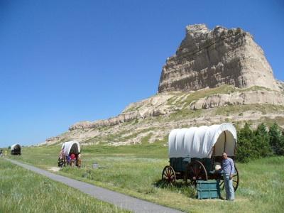
Three replica wagons used by the pioneers, each of a different variety, are near the visitor center. A trail beginning at the visitor center parallels the Oregon Trail and then leads directly along the trail where the swale and ruts are clearly visible.
Wednesday night the plan was to reach Fort Laramie National Historic Site in eastern Wyoming, and then spend Thursday viewing the famous Guernsey ruts, one of the most impressive sights on the Oregon Trail.


Add comment