'Pirates used to hide in these keys,' Carlos, our guide, tells us as our boat swings behind a small, steep-sided island. Numerous forested islets dot the shoreline like floating haystacks. 'English and French pirates hid in Samaná Bay to ambush Spanish gold ships leaving Santa Domingo. The 58 cays and inlets made perfect hiding places.'
Motoring along the rugged shoreline of Los Haitises National Park in the Dominican Republic, our boat swerves around the rocky islets like a skier racing downhill. Then we brake and pull into a small cove with a postcard-perfect beach tucked up against a 100-foot-high hillside, but we don't stop. The boat continues into the mouth a cave with a gushing freshwater river.
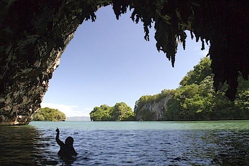
Many caves are best explored by swimming. George Oxford Miller photo.
We dive in the mountain stream and float out with the current. White egrets and brown pelicans watch from low trees, as do three fishermen mending their nets in the shade of coconut palms. They live in tents on a beach in an adjacent cove. Rivers from the rainforest nourish mangrove estuaries that make Samaná Bay one of the richest fisheries in the Caribbean. Except for the plastic cording of the nets, the fishing lifestyle has changed little over the last millennia.
The name "Los Haitises" means 'mountain range' in the language of the Táino Indians, the original inhabitants that Columbus found, and promptly exterminated, when he discovered the island. The national park preserves 204,109 acres of the rugged hills, virgin rainforest, and coastline. A marine sanctuary protects the 40-mile long, 15-mile wide Samaná Bay.
Over the eons, tropical rainfall eroded the uplifted limestone plateau into dense clusters of conical, 100-foot-high hummocks. From the airplane window on our approach to Santo Domingo, the forest-covered hills look like an inverted egg carton. Sinkholes form shallow caves and grottos throughout the hilly range.
With little development, the pristine habitats in the park harbor the only two remaining endemic terrestrial mammals on the island. The Hispaniolan hutia, a tree-dwelling rodent the size of a muskrat, is the last surviving native rodent. The primitive Hispaniolan solenodon, a small insectivorous mammal, produces a toxic saliva similar to the duck-billed platypus. Most of the island's 315 bird species, which include 20 endemics, also thrive in the park. Large colonies of magnificent frigate birds and brown pelicans nest in the low trees covering Cayo de los Pájaros, Bird Key. Downy, white pelican chicks watch from their nests as we circle the island. The red throats of the male frigate birds dot the trees and hundreds circle overhead like a swarm of bees.
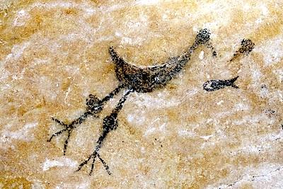
Prehistoric rock art can be found in the park's many caves. George Oxford Miller photo.
Before the Spaniards arrived, the Táinos farmed the valleys, fished the bay, and left their mark, literally, in the caves of Los Haitises. Our boat continues along the scalloped coastline to a tunnel-like mangrove inlet. A trail leads to Cueva de la Linea, a rounded cavern formed by a massive sinkhole. Rays of light stream through weathered openings in the roof and illuminate the ancient art of the island's first artists.
Pictographs made 500 to 1,000 years ago decorate the smooth limestone walls. Images of egrets catching crabs, dolphins, owls, and bizarre human shapes and shaman masks offer a glimpse into the culture of a lost people.
The Táinos are gone, but the same natural wonders that inspired their drawings fascinate us today. Line drawings of humpback whales adorn the ageless art gallery, while postcards of whales are best sellers in village markets. Records indicate that Columbus was the first foreign visitor to stare in wonder at the numerous humpback whales in Samaná Bay.
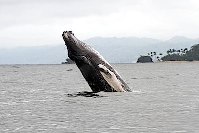
Samana Bay is a great spot for watching whales. George Oxford Miller photo.
Whale-watching season lasts mid-January through Mid-March. To see the whales, we join a tour of 15 people in a small, open boat. Other tours crowd 50 to 80 people on a catamaran, not optimum for seeing the illusive creatures. About 1,500 humpbacks winter in the bay, making it one of the most important winter nurseries and breeding grounds for Atlantic humpbacks. The World Wildlife Fund classifies Samaná Bay as one of the best whale watching locations in the world. We find a mother and calf, the most common sighting, in just a few minutes.
The back of the 50-foot long, 40-ton female arcs through the waves like scissors through silk with a juvenile at her side. The pair crosses in front of the boat and runs parallel to us only a few dozen yards away. The female's tail flips up and disappears beneath the waves as they dive deep. We follow their direction, searching the waves. Then the female breaches and soars into the air. She jumps again and the juvenile joins the fun and bursts from the waves. This time our cameras, cell phones, and camcorders are ready.
Access to Los Haitises National Park, located across the bay from Samaná Peninsula, is limited to a single road from the mainland or a 30-minute boat ride from the peninsula.
The only accommodations inside the park, the Paraiso Caño Hondo ecolodge 5 miles from Sabana de la Mar, has 28 rooms, so most visitors experience the park by boat. Tours to the keys and shoreline caves leave from Sanchez and Samaná; whale-watching leaves from Samaná. Hotels and local tour companies can arrange outings.
Travel writer George Oxford Miller wrote the best-selling app Guide to the Grand Canyon, Flagstaff, and Williams. His last story for the Traveler was on Agostini National Park in Chilean Patagonia.


Add comment