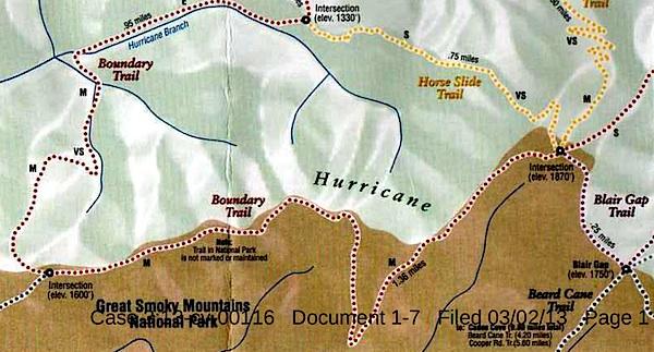
This map, said to have come from Blackberry Farm Resort, shows two trails -- the Boundary Trail and the Blair Gap Trail -- that are not listed on Great Smoky Mountains National Park's official trail map/Southern Forest Watch
Sometime in recent years two trails running more than a mile-and-a-half were cut into the backcountry of Great Smoky Mountains National Park, allegedly for the use of a private resort that borders the park, according to court documents.
When contacted by the Traveler, park officials declined to discuss the trails, or even acknowledge their existence, as their presence has been raised in litigation. However, the "Boundary Trail" and "Blair Gap Trail" depicted on a trail map purportedly handed out by the Blackberry Farm Resort do not match any trails on the park's official trail map. Together they run along the park's western boundary roughly from the Beard Cane Trail to the Cane Creek Trail. Officials at the resort, where rooms start at $745 a night, had no immediate comment when asked about the trails this week.
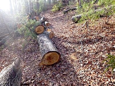
A trail of downed trees allegedly marked an illegal trail cut in Great Smoky Mountains National Park/Southern Forest Watch
The existence of the trails surfaced in connection with a lawsuit brought against the Park Service by Southern Forest Watch, a nonprofit group organized to overturn the park's $4 per night fee charged on backcountry travelers. Though not central to the fight over the backcountry reservation system, the group pointed to the "illegal trail system" as part of a pattern of "political patronage" that former park Superintendent Dale Ditmanson oversaw. Mr. Ditmanson, who instituted the backcountry fee system in 2013, retired from the Park Service earlier this year.
By allowing the Blackberry Farm Resort to maintain these trails for the use of their customers and residents, Great Smoky Mountains officials were limiting the general public's access to the park's backcountry and allowing it to be impaired, charges Southern Forest Watch's lawsuit.
The Park Service, in court documents responding to Southern Forest Watch's complaint, denied allowing a "private resort to maintain and utilize their own separate, exclusive network of trails into, on and within the boundaries" of the park. However the agency did admit that there was a signpost with a map box located outside the park boundary and that "any signs that were erected within Park boundaries by Blackberry Farm Resort were erected without permission from NPS and have since been removed."
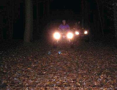
These ATVers allegedly were entering Great Smoky Mountains National Park from the Cane Creek Trailhead/Southern Forest Watch
The trail map showing the Boundary and Blair Gap trails came from the map box on the signpost, according to Southern Forest Watch's lawyer.
The trail signs and maps were found by John Quillen, a member of Southern Forest Watch. A park volunteer who regularly hikes the Cane Creek Trail to help maintain it, Mr. Quillen discovered the Boundary Trail in 2009 when he came upon a trail of trees that had been chainsawed down. He and some friends also heard a chainsaw at work, and encountered riders on two all-terrain vehicles who allegedly claimed they had come from Blackberry Farm. Photos of a trail sign, the ATV, and downed trees are part of Southern Forest Watch's court filing.
No court date for the matter has been set.


Comments
The background information provided by Gary Wilson is greatly appreciated. From the map, it appears the trails in question clearly intersect with other maintained Park trails, so are fully accessible to the public. The photo shows many windfall trees that have been bucked (not felled) and rounds rolled off the trail. No erosion, injury to living trees or standing snags, or other damage to Park natural resources is apparent nor is alleged by SmokiesBackpacker. It appears that whoever has maintained them has done a public service.
"Just because it doesn't appear on a Park map doesn't mean it doesn't exist" is so very true. Only half the trails built during the 1930s CCC-New Deal era remain today in many major national parks and forests. Countless abandoned homesteads, native American sites, ancestral burial sites and graveyards, early mines, hunting cabins, ranger stations, shelters, trails, etc exist within Parks, even within Wilderness parks. Quests to rediscover (not disturb, just visit) these is a wonderful reason to explore the less-often visited corners of our Parks.
Yeah this article has many baseless accusations in it, but it's kind of expected from the group involved.
I spend many hours filming in the park on many backcountry trails. Sometimes, i'll explore manways, or if i'm trying to film fish, fields of blooming plants, and especially wildlife i'll venture off trail. I've found many interesting things in the park that way. Right now with all the heath balds blooming, it's the best way to get unique shots and perspectives. All National Parks that i've ever been in will not actively promote off trail hiking or climbing activities. That's always been the case. They won't deny it, they won't promote it, and they won't bar you from doing it. Kurt should know this.
Point is, I know areas of the park very well. A good portion of the park is managed as wilderness, but only in name only. Parks that are declared wilderness, have much different policies, but not all National Parks have declared wilderness, in fact it seems that being managed "as wilderness" instead of actual wilderness is more of the norm in the National Parks. Wilderness areas bar chainsaws, and all trail clearing work has to be maintained with hand tools. That's not the case in the Smokies, and chainsaws are used in the park to clear existing trails, and in some cases manways leading to graveyards etc. The tornado that hit beard cane trail and blew apart large swaths of forest would probably never have been cleared without the use of chainsaws. So, it's a catch-22 when it's declared wilderness.
Let me also say this - judging from the Cane Creek Trail, and where this manway starts along it, by the noted sign called "The Chicken Crossing".. I can pretty much cross it off my list that ATV's can access this ridgeline from the start of that trail and then travel the entire way to beard cane on the boundary trail that follows Hurricane ridge. I can also mark off my list that there was any logging on the private land where the Boundary Trail starts on this private area near Cane Creek. But, it's been a few months since I was over there. So maybe things have changed? I doubt it, but the good thing is, these properties don't seem to bar people from hiking on their property if they leave the park on these old manways, so it can be fact checked..
We will forget for a moment that the resort in question refused to deny the accusations. And the NPS conceded in the lawsuit that the trail signs existed on NPS land as documented in this article and the text of the lawsuit. That is inconvenient to Wilsons' continued justifications. He works for the park. But I will tell you where to go see for yourself.
Just go to the intersection of Ace Gap and Beard Cane Trail and take a left if coming up Beard Cane or keep going straight if dropping down Ace Gap. Very shortly you will come to where the private resort trail sign used to be before the NPS made them remove it. (That is a fact documented by the NPS in their rebuttal to the Southern Forest Watch's lawsuit) At that juncture less than a quarter mile in the "boundary trail" splits and drops back into the private property. Look at where the maintained trails continue and look at where the NPS boundary sign is on the trees. There is no question that those trails are on NPS lands and someone cut those trees at some time. No doubt. Understand that the private resort has had plenty of time to cover their tracks since these allegations were documented. The lawsuit was filed well over a year ago and that is precisely when the NPS went there to "investigate" and make them "remove" the signs. I suppose the cut trees weren't so important since the resort was doing such a service by keeping that old trail clear, right? And watch out for horse leavings. What? Horses on the boundary trail? How in the world would horses get....oh yeah, never mind.
Gary, I do think the "Traveler" article raises questions. I think the NPS does a disservice to the public by not addressing the issue, after all the taxpayers are footing the bill. I do think we hide behind the litigation issue, have witnessed it myself on both sides of the table. If mistakes were made, hey, we are human, but the NPS should release what they know, it was on their watch. I also see the issue of "managed as wilderness" as opposed to official designation. I do not agree with it. The purpose of the act is reduce impacts in these areas in order to maintain them on a sustainable basis. Transparency is the best course, unless of course there is something that the parties involved do not want disclosed. I simply cannot accept the position that use of chainsaws and ATVs to build or clear a section of the trail inside the park without authorization from the NPS, proposed wilderness addition or not, is acceptable. The whole story is not being told I am afraid.
Once again, the documentation of these photos is very suspect. A tornado hit this area in 2011. I posted the video that was created by the GSMA from that event. An entire 13 mile section of forest was whipped bare during that event. The Beard Cane trail, which is what John is allegedly accusing the park having ATV's on from blackberry farms was shut down to the public, as trail crews worked to clear the trail. It reopened last year, about 2 years after the event. Chainsaws were used to clear the tree debris. Were these photos actually from beard cane? I question it. I really do.
I have hiked in Cane Creek, and there is no way an ATV can get up hurricane ridge from there. I'm flat calling this article out, because the way it's worded is that ATV's are running along the boundary from Cane Creek to Beard Cane on Hurricane Ridge along the old manway by "sheiks and aristocrats that pay to stay at Blackberry Farms".
I say if you know the terrain, you would be shaking your head at these accusations too.
I don't work for the NPS, FYI. I work with the GSMA. Point is that you make some accusations that are not exactly true.
Here are the exact words in this article!
"Sometime in recent years two trails running more than a mile-and-a-half were cut into the backcountry of Great Smoky Mountains National Park, allegedly for the use of a private resort that borders the park, according to court documents."
I told you that these were not cut recently, but these trails have existed as manways. Granted, nature has reclaimed these manways over 70 years, but the way this article is worded, you accuse a private resort of creating new trails.
Gary, I really don't have a horse in this race, but I'd like to see where park regulations let anyone walk into an area that's off the official trail map and cut down trees or otherwise "maintain" a trail not recognized by the Park Service. I did a quick search of Great Smoky's website and couldn't find any information on that. Perhaps you could point me to it.
At the same time, the National Park Service's 2006 Management Policies state in Section 9.2.2. that, "All trails and walks will be carefully situated, designed, and managed to (emphasis added)
* reduce conflicts with automobiles and incompatible uses;
* allow for a satisfying park experience;
* allow accessibility by the greatest number of people;
* and protect park resources.
If you accept that, clearing a path that might have been in use five decades ago or longer and since fallen out of use would seem to be illegal.
Furthermore, the Code of Federal Regulations specifically bans "(1) Possessing, destroying, injuring, defacing, removing, digging, or disturbing from its natural state: (ii) Plants or the parts or products thereof.
As you noted above, the map that has been introduced as evidence states that the NPS does not maintain or mark the trail. Whoever produced the map added that language it would seem.
And while the NPS does generally permit cross-country travel, I have yet to find a park that says it's OK to blaze your path by clearing a trail.
Gary, according to this organizational chart, your employer, the GSMA is affiliated with the NPS. It appears as if they are directly tied financially and bureaucratically.
http://www.smokiesinformation.org/images/uploads/Org_Chart_6-10-2013.pdf