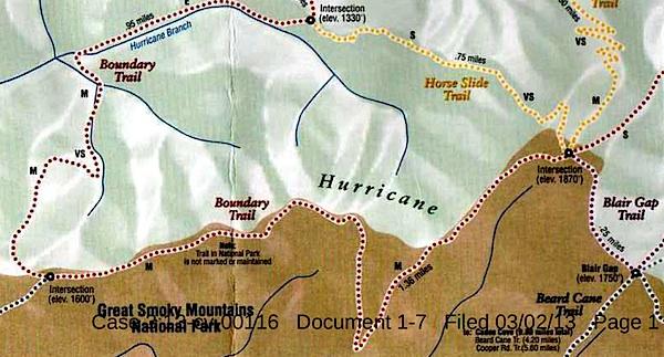
This map, said to have come from Blackberry Farm Resort, shows two trails -- the Boundary Trail and the Blair Gap Trail -- that are not listed on Great Smoky Mountains National Park's official trail map/Southern Forest Watch
Sometime in recent years two trails running more than a mile-and-a-half were cut into the backcountry of Great Smoky Mountains National Park, allegedly for the use of a private resort that borders the park, according to court documents.
When contacted by the Traveler, park officials declined to discuss the trails, or even acknowledge their existence, as their presence has been raised in litigation. However, the "Boundary Trail" and "Blair Gap Trail" depicted on a trail map purportedly handed out by the Blackberry Farm Resort do not match any trails on the park's official trail map. Together they run along the park's western boundary roughly from the Beard Cane Trail to the Cane Creek Trail. Officials at the resort, where rooms start at $745 a night, had no immediate comment when asked about the trails this week.
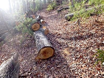
A trail of downed trees allegedly marked an illegal trail cut in Great Smoky Mountains National Park/Southern Forest Watch
The existence of the trails surfaced in connection with a lawsuit brought against the Park Service by Southern Forest Watch, a nonprofit group organized to overturn the park's $4 per night fee charged on backcountry travelers. Though not central to the fight over the backcountry reservation system, the group pointed to the "illegal trail system" as part of a pattern of "political patronage" that former park Superintendent Dale Ditmanson oversaw. Mr. Ditmanson, who instituted the backcountry fee system in 2013, retired from the Park Service earlier this year.
By allowing the Blackberry Farm Resort to maintain these trails for the use of their customers and residents, Great Smoky Mountains officials were limiting the general public's access to the park's backcountry and allowing it to be impaired, charges Southern Forest Watch's lawsuit.
The Park Service, in court documents responding to Southern Forest Watch's complaint, denied allowing a "private resort to maintain and utilize their own separate, exclusive network of trails into, on and within the boundaries" of the park. However the agency did admit that there was a signpost with a map box located outside the park boundary and that "any signs that were erected within Park boundaries by Blackberry Farm Resort were erected without permission from NPS and have since been removed."
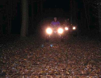
These ATVers allegedly were entering Great Smoky Mountains National Park from the Cane Creek Trailhead/Southern Forest Watch
The trail map showing the Boundary and Blair Gap trails came from the map box on the signpost, according to Southern Forest Watch's lawyer.
The trail signs and maps were found by John Quillen, a member of Southern Forest Watch. A park volunteer who regularly hikes the Cane Creek Trail to help maintain it, Mr. Quillen discovered the Boundary Trail in 2009 when he came upon a trail of trees that had been chainsawed down. He and some friends also heard a chainsaw at work, and encountered riders on two all-terrain vehicles who allegedly claimed they had come from Blackberry Farm. Photos of a trail sign, the ATV, and downed trees are part of Southern Forest Watch's court filing.
No court date for the matter has been set.


Comments
Justin. Gertrude indeed. But the point remains the same.
If one ignores the irony of the statment, which would seem to be S's point.
I personally hiked out to the intersection of Ace Gap Trail & Beard Cane trail last May 5/27/2013. I wanted to see the closed back country sites#7 and #4; to see if there was extensive tornado damage. I also wanted to see if I could find the trail system that SmokiesBackpacker described.
I took a day hike late in the afternoon and got to the intersection of Ace Gap & Beard Cane. Here is a link to photos I took at that intersection: https://plus.google.com/u/0/photos/103438902370192585064/albums/6017102677493140993
I did find a very well maintained trail which lead from this intersection which had a purple color blaze on it. I followed it for about .1 miles before turning back. I did not go further as it was getting late in the afternoon and I had a commitment in Townsend that evening. I am posting the NPS trail intersection photos and also the purple blaze on an old shattered tree which this well maintained trail terminates into this intersection.
I want to go back again and backcountry camp close to this intersection to discover more of what this purple trail blaze leads to learn more on my own.
In my opinion this at the very least validates the questions/concerned raised by SmokiesBackpacker and this article which Kurt published. We as taxpaying citizens of this nation should have a right to know what is going on here. It does not seem right. Why is there a trailhead sign here? Why is there a purple trail blaze here?
Gary Wilson, You are extremely passionate on your opinions regarding these issues. I respect that. However, I have begun to look at this issue with my own eyes. The more I learn about this issue and others similiar to this in relation to the NPS, the more I am disappointed I am.
Maybe SmokiesBackpacker, Gary Wilson and I all register for a backcountry site close by this intersection. Then in the morning explore these trails together and observe all this together. Another coincidental issue to this trail system is why did CS 7 & CS4 close? Why is CS11 closed? So this would mean that we would need to stay at CS3.
I am just a man whom loves the GSMNP whom lives in Marietta Georgia. I do not know nearly as much about the GSMNP as SmokiesBackpacker or Gary Wilson. However, I do know when I sense that something is not right. I truly believe that this trail system and the backcountry fee is not right and sure would like to know the truth.
Thank you again Kurt for bringing issues like this to the public.
No offense Andrew, but your photos do not show any ATV activity, signs of ATV treads, or that the hurricane mountain manway is anything other than an old manway trail that recieves moderate to light use. A purple blaze on a tree? Ok. Well, that is possibly grafitti... possibly a marking for a diseased tree, etc.
There are many old trails that are no longer on park maps. If you have an old Nat Geo map from 10 years ago, you'll see trails on it that are no longer maintained if you compare it to the newest one. Greenbrier pinnacle is one such trail, and even though it no longer has a sign on it, people still use it, and a worn path can still be found in sections. I've already stated in this thread, if you care to read it, that there are many manways that lead into the large boundary trail section that covers around 50 miles of trail on the Northwest side of the park. The Northwest side of the park is surrounded by private lands, and these manways follow drainages, or ridgelines that have existed for a long time that date back to settlement, and the Cherokees. I've stated that already. The park maintains more official trails in GSM then most national parks. In fact, only Sequoia has more total trails than the Smokies. But, there are probably over a thousand miles of trails, if you count manways. The park doesn't count these and doesn't deny or state of their existence. Every park is like this. Maybe I expected a little too much here. Not everyone (well most) go to National Parks and try to get into areas not on a map. I went into the painted desert recently, and there are no "official trails" in this wilderness, even if there are slightly visible foot paths in sections. This is nothing out of the ordinary in most national parks.
Sometimes because of blowdowns, rock slides, etc trails are abandoned. Look at what keeps happening on Gunter Fork currently. Slide after slide, every few years taking out the trail and making it unstable. I think you guys have high expectations when a place like Ramsey Creek gets it's main footbridge blown out, and during the same time period Gunter Fork slides off the mountain, and then you still have them trying to clear forest blow downs from tornados and derechos, and the park only has so many trail crews to cover 900 miles of trails. And don't think for a second the park is going to approve volunteers to cut down blow downs, especially volunteers that aren't certified.. There is a process.
An F4 tornado went through. What happens when an F4 goes through a city? It takes countless man hours, and heavy equipment to move things and restore things. The Smokies trail crew did not have these things at their disposal, because of the managed wilderness status it recieves. This park gets hit a lot by crazy windy chaotic weather... I also posted the trail damage report in my first post here. You can see it, and see where it went and what areas were effected. I also posted a video. I realize the Southern Forest Watch crowd probably thinks an F4 tornado didnt do any damage on these trails, but hey... whatever. Beliefs are just that - BELIEFS. Im a man that likes fact finding through science and evidence. I posted some evidence above. If you want me to I can show you video of damage in Abrams Creek too from my time floating it.
Here are the allegations: That the park allowed blackberry farms to cut a trail (I already stated this is an old manway), and that ATV's are being used by Kings and Aristocrats while the park turns a blind eye.
I"m in the park a lot. I consider myself an eye in the park too. So, I have never heard, or seen ATVs in any of my time in the park. Not ONCE! Of course, i'm in the parks quite a bit, so I don't expect Kurt to take my word over other people. I also have never seen any reports of ATVs being used in the park by a single person And like I said, I'm on a lot of hiking forums, and our facebook page for the GSMA is one of the largest fan bases in the National Park system. We have millions that it reaches, and I have yet to see or have photos or allegations of ATVs in the park, other than here..
Trust me, i'm documenting both trail sides of this old manway to show that there is no way ATVs could use this section from cane creek to beard cane.
I also expect more from National Parks Traveler than to just be the National Enquirer of National Park related news.
For what it's worth, Gary, Yellowstone has more than 1,100 miles of hiking trails, which is more than Sequoia.
Beyond that, though, I'm not sure what you have against the Traveler. All we did is report straightforwardly on a court case that brought matters to light which even you apparently were unaware of, and we haven't belittled your comments. Indeed, the Traveler has publicized the good work and programs of the Great Smoky Mountains Association down through the years.
At the Traveler we take great interest and concern in what goes on in the National Park System, and when allegations such as the ones that led to this article arise, we're going to report on them.
That is an easy one Kurt. He doesn't like the exposure.
Of course this is a legitimate story and you have covered it in a very balanced manner.
For one of the few times, I find myself in complete agreement with ec. You have covered this story, Kurt, in an impartial manner. Thanks for bringing it to our attention.
Rick
I have been hiking this area extensively long before this all came to light. The old hurricane mountain manway has been resurrected as the blair gap and boundary trails maintained by blackberry farm as shown on the map on this article. The purple blazes arent "graffiti or marking for a diseased tree", they are to mark the trail blackberry farm has cleared inside the park. At a point about a mile and a half from Blair gap,( blazed with red/ purple the whole way), the boundary trail leaves the park to the right into blackberry farm lands, while the old manway descends to the left to hesse creek and eventually connects to cane creek.This part isnt maintained and is thoroughly overgrown. Down at cane creek however, is where any atvs must have went up to meet the Cane creek trail inside the park. Sometime before 2011 a trailhead sign was put up by the park in blair gap, so they obviously knew people were entering the park on the blair gap/ boundary trails. There are many old ccc trails in the park that are in good shape but no longer maintained by the park so,personally i kind of like that they are keeping the old trail open. However, is blazing an old no longer maintained/official park trail and clearing it out without authorization illegal? yeah probably. Has the park service turned a blind eye to it for many years? obviously so.