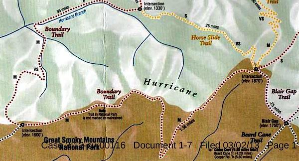
This map, said to have come from Blackberry Farm Resort, shows two trails -- the Boundary Trail and the Blair Gap Trail -- that are not listed on Great Smoky Mountains National Park's official trail map/Southern Forest Watch
Sometime in recent years two trails running more than a mile-and-a-half were cut into the backcountry of Great Smoky Mountains National Park, allegedly for the use of a private resort that borders the park, according to court documents.
When contacted by the Traveler, park officials declined to discuss the trails, or even acknowledge their existence, as their presence has been raised in litigation. However, the "Boundary Trail" and "Blair Gap Trail" depicted on a trail map purportedly handed out by the Blackberry Farm Resort do not match any trails on the park's official trail map. Together they run along the park's western boundary roughly from the Beard Cane Trail to the Cane Creek Trail. Officials at the resort, where rooms start at $745 a night, had no immediate comment when asked about the trails this week.
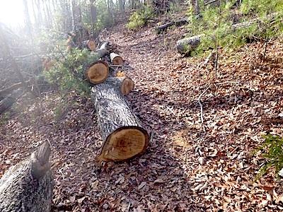
A trail of downed trees allegedly marked an illegal trail cut in Great Smoky Mountains National Park/Southern Forest Watch
The existence of the trails surfaced in connection with a lawsuit brought against the Park Service by Southern Forest Watch, a nonprofit group organized to overturn the park's $4 per night fee charged on backcountry travelers. Though not central to the fight over the backcountry reservation system, the group pointed to the "illegal trail system" as part of a pattern of "political patronage" that former park Superintendent Dale Ditmanson oversaw. Mr. Ditmanson, who instituted the backcountry fee system in 2013, retired from the Park Service earlier this year.
By allowing the Blackberry Farm Resort to maintain these trails for the use of their customers and residents, Great Smoky Mountains officials were limiting the general public's access to the park's backcountry and allowing it to be impaired, charges Southern Forest Watch's lawsuit.
The Park Service, in court documents responding to Southern Forest Watch's complaint, denied allowing a "private resort to maintain and utilize their own separate, exclusive network of trails into, on and within the boundaries" of the park. However the agency did admit that there was a signpost with a map box located outside the park boundary and that "any signs that were erected within Park boundaries by Blackberry Farm Resort were erected without permission from NPS and have since been removed."
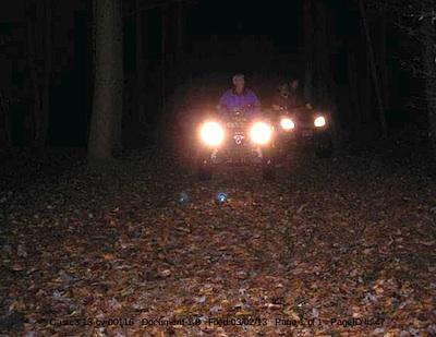
These ATVers allegedly were entering Great Smoky Mountains National Park from the Cane Creek Trailhead/Southern Forest Watch
The trail map showing the Boundary and Blair Gap trails came from the map box on the signpost, according to Southern Forest Watch's lawyer.
The trail signs and maps were found by John Quillen, a member of Southern Forest Watch. A park volunteer who regularly hikes the Cane Creek Trail to help maintain it, Mr. Quillen discovered the Boundary Trail in 2009 when he came upon a trail of trees that had been chainsawed down. He and some friends also heard a chainsaw at work, and encountered riders on two all-terrain vehicles who allegedly claimed they had come from Blackberry Farm. Photos of a trail sign, the ATV, and downed trees are part of Southern Forest Watch's court filing.
No court date for the matter has been set.


Comments
It has been a couple of years since I have been down there. So. don't know the truth about this, but about a mile or so of the boundry trail actually veers out onto the blackberry property, starting wher cane branch leaves the park. There were "PRIVATE PROPERTY NO TRESSPASSING" signs at the park line. It reenters the park about where this map shows the western intersection. So, they could tie onto that one mile section that is on their land legally. But, I'm not sure if horses are allowed on those trails, and I know atvs are not.
"...Trust me, i'm documenting both trail sides of this old manway to show that there is no way ATVs could use this section from cane creek to beard cane..."
Gary, that "private resort" (that the National Park Service itself identified in filings) knows full well how many affidavits exist SWEARING that these 4 wheelers were used in the Great Smoky Mountains backcountry. There are a number of witnesses.
Give it up Gary.
Gary, My home is about four miles by trail from where the cane creek trail leaves the park. If I get a littlt time, I may walk down there and check this out.
Kurt, just to clarify... There are more total trails in the Smokies than all other parks but Sequoia. But just counting trial miles there are a few parks that probably have more.
Thanks freehiker. I've been down that trail before. I'm fairly well convinced that ATV's cant go from Cane Creek to Beard Cane via hurricane ridge. I've flown over this area a few times, and i've done my share of ATVing in BLM lands in the West. I have my doubts anything but a very skilled ATV rider could even attempt it, and that's if they built a ATV trail that was wide enough. I'm not sure about the old manway from Blair Gap to where Beard Cane starts. From the few images i've seen nothing shows me it's anything but a lightly used manway.
A person above already stated this is the case too. But, by all means walk Cane Creek .. ATV's are illegal on trails inside the park. The statement in the article pretty much sums it up:
Unfortunately, some areas of the park are not surrounded by national forest, which gives a buffer zone. Many National Parks in the west have that advantage, but not so much in the East. Shenandoah, the Blue Ridge Parkway, Cumberland Gap, etc all have that problem. Even a decade from now, this whole ridgeline could be nothing but mcmansions. That's already happenening, as houses continue to creep up the ridges. And since the zoning in the region is a bit of a joke and they seem to rubber stamp any real estate project, it will just continue. Houses already butt up to the park border, and many were just built this past decade. But, this happens in just about every place. Even in the west, many national forest areas that are next to private lands are coveted and the same sort of mcmansion and ranchette development happens. I've seen it a lot.
If anyone was wondering why this private resort was allowed to run wild and "claim" their own trail system in the Smokies, one needs to look no further than the second paragraph of this article to help fill in the plaid shirted dots.
http://articles.chicagotribune.com/1996-02-19/news/9602190118_1_blackber...
This senator controls the Smokies for his private enterprise from his friends who get contracts for horse stables in Cades Cove (we're talking big money here) to his buddies who were going to make a ton when the archives center was placed in his backyard. (a conservative group called him out on this and his buddies were forced out of embarrassment to "donate" those properties) Ditmanson refused to vet North Carolina for the proposed archive center. It was part of the above Senator's "legacy building" campaign. It is well known that he and former Smokies Superintendent Ditmanson are tight buddies and he turned a blind eye to Ditmanson's crony politics. This senator is as crooked as they come. http://realchange.org/alexandr.htm A good story would be to explore Ditmanson's distribution of concession contracts from Leconte Lodge to the Cades Cove campground store.
He found a real compatriot in the former Superintendent and his assistant. I wonder how many nights he spends at Blackberry on the house. The former manager of Blackberry was a guy by the name of Alexander. I have no idea if there is a connection. But it makes you wonder.
All this came to light because Ditmanson didn't think through his backcountry fee scheme. I'll bet more than a few phone calls have gone back and forth as a result.
SmokiesBackpacker,
You might be interested in your own digital footprint that shows a more honest account of what you are alleging... In this account I see no shots of "tree cutting". No signs of ATV usage. And not a single "No Tresspassing" sign on park property on this old manway route. Hence, you calling it a "private trail" is somewhat skewed.
http://web.archive.org/web/20140526233648/http://www.southernhighlanders...
Gary,
And to think we were all anxiously awaiting the scientific results of your fact finding mission to those trails. You obviously found nothing from which to dig yourself out of that hole.
Why do you lie so much, Backpacker?