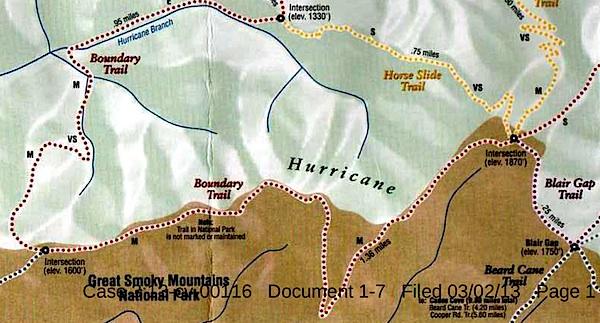
This map, said to have come from Blackberry Farm Resort, shows two trails -- the Boundary Trail and the Blair Gap Trail -- that are not listed on Great Smoky Mountains National Park's official trail map/Southern Forest Watch
Sometime in recent years two trails running more than a mile-and-a-half were cut into the backcountry of Great Smoky Mountains National Park, allegedly for the use of a private resort that borders the park, according to court documents.
When contacted by the Traveler, park officials declined to discuss the trails, or even acknowledge their existence, as their presence has been raised in litigation. However, the "Boundary Trail" and "Blair Gap Trail" depicted on a trail map purportedly handed out by the Blackberry Farm Resort do not match any trails on the park's official trail map. Together they run along the park's western boundary roughly from the Beard Cane Trail to the Cane Creek Trail. Officials at the resort, where rooms start at $745 a night, had no immediate comment when asked about the trails this week.
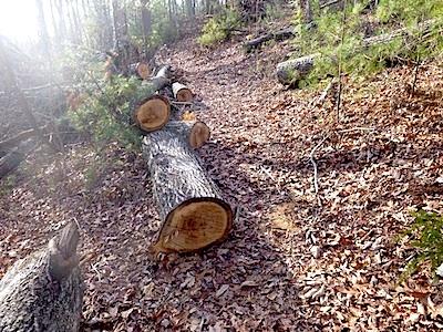
A trail of downed trees allegedly marked an illegal trail cut in Great Smoky Mountains National Park/Southern Forest Watch
The existence of the trails surfaced in connection with a lawsuit brought against the Park Service by Southern Forest Watch, a nonprofit group organized to overturn the park's $4 per night fee charged on backcountry travelers. Though not central to the fight over the backcountry reservation system, the group pointed to the "illegal trail system" as part of a pattern of "political patronage" that former park Superintendent Dale Ditmanson oversaw. Mr. Ditmanson, who instituted the backcountry fee system in 2013, retired from the Park Service earlier this year.
By allowing the Blackberry Farm Resort to maintain these trails for the use of their customers and residents, Great Smoky Mountains officials were limiting the general public's access to the park's backcountry and allowing it to be impaired, charges Southern Forest Watch's lawsuit.
The Park Service, in court documents responding to Southern Forest Watch's complaint, denied allowing a "private resort to maintain and utilize their own separate, exclusive network of trails into, on and within the boundaries" of the park. However the agency did admit that there was a signpost with a map box located outside the park boundary and that "any signs that were erected within Park boundaries by Blackberry Farm Resort were erected without permission from NPS and have since been removed."
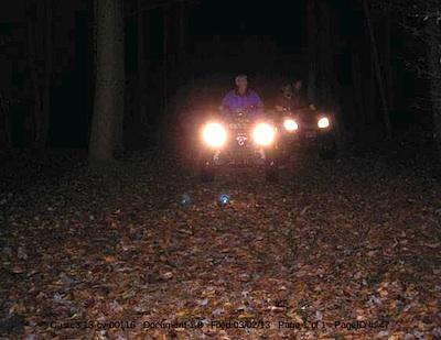
These ATVers allegedly were entering Great Smoky Mountains National Park from the Cane Creek Trailhead/Southern Forest Watch
The trail map showing the Boundary and Blair Gap trails came from the map box on the signpost, according to Southern Forest Watch's lawyer.
The trail signs and maps were found by John Quillen, a member of Southern Forest Watch. A park volunteer who regularly hikes the Cane Creek Trail to help maintain it, Mr. Quillen discovered the Boundary Trail in 2009 when he came upon a trail of trees that had been chainsawed down. He and some friends also heard a chainsaw at work, and encountered riders on two all-terrain vehicles who allegedly claimed they had come from Blackberry Farm. Photos of a trail sign, the ATV, and downed trees are part of Southern Forest Watch's court filing.
No court date for the matter has been set.


Comments
Mr. Wilson--You would be more than welcome to express your opinions on GotSmokies.com; indeed, one of the underlying reasons that forum was established was to allow all opinions, from all perspectives, room for expression without fear of being stifled (as had happened on another forum, the Knoxville newspaper's GoSmokies). The sole requirement, as I understand it, is that one be willing to use their real name. You are already, to your credit, doing that.
Jim Casada
The trail-clearing allegations could be proved either true or false fairly easily....a trip on these trails/manways looking for evidence of clearing/maintenance/chainsaw use. We've seen evidence of, and eyewitnesses to, 1 side of the story but not the other.
It's hard to undo trail clearing or use of chainsaws. If those things hadn't been done, I'm sure Blackberry would have vehemently denied this by now. They haven't to my knowledge. NPS is more fortunate in that they can use the court case as reason for silence.
Tom, haven't got back there yet. I've been busy on other projects and spent a majority of my week up in the Spruce-fir forest areas. I haven't had a full day to my disposal, which is what will be required.. Regardless, it's on my list to get out there in the next couple of weeks.
Jim, I respect that, and ill keep that in mind. Sometimes the tribalism and constant negativity can be a bit of a drag from that forum. I prefer a more simple even flowed chi to the dialouge, which is what i'm asking for you to consider..
Regardless, you'd find that I share a similar affinity for being in the mountains, and living a more laid back mountain lifestyle as many on your side. There is little better than being out in the mountains - at all times of the year. Whether it's in the rockies, or here in the southern appalachian. It's all very similar.
I also support some other ideas and opinions that come from some of your members, especially in regards to wilderness. I would also like seeing more designated wilderness areas in the Appalachians, including the Smokies. I think that is necessary as the world continues to grow in population, and the truly wild areas of our country become smaller and smaller islands. I personally want to see most of the Smokies designated wilderness.
I also feel once my boy is ready to backapck, i'll be leading him, and other youth (whether they are dissadvantaged, suffer from too many urbanized nature fearing parents, or just plain poor to not be able to get to the mountains etc) on backpacking excursions in the Smokies. I plan on getting kids that might not get the opportunity via thier own families to get out in the backcountry and experiencing nature at its purest. I think having kids appreciate the wilderness is a necessity. They are the next ones willing to keep it protected and hopefully in a wild state that continues to get wilder over time, not less. I think there needs to be an emphesis on teaching kids to backpack, experience the backcountry, and practice leave no trace. By all means, get them out walking, crawling on their knees and looking at weird salamanders and bugs that they dont ever see in the cities they come from. Get them taking a fly rod back into some of the streams in the Smokies and catching their first brookie. I think it's important that the backcountry is used, and in more areas than just the AT and it's shelters. I also feel claustorphobic in places like Cades Cove and Pigeon Forge during those peak visitation times where 99% of the tourists don't even leave their car between the two. To me that's not a "quintessential smokies experience". To me, the backcountry is the quintessential Smokies experience.
Where we disagree is that I definitely don't want to see it ever fall back into the hands of the state, or see it privatized, and definitely not ran as a county park by a bunch of half wit tea partiers because they won an election with 300 votes in their counties that surround the park. I think the federal status is important for many reasons because it creates a set guideline of national standards that these parks should follow. I also think there needs to be a few more backcountry rangers in the Smokies. One should be able to reach a spot anywhere in the park within a few hours time. Rangers need to be in the backcountry. Everything from plant and bear poaching, to S&Rs, to people running dogs in the backcountry, to people setting up tents in sensitive areas (you'd be suprised how many times ive encountered people in tents not where they are supposed to be) can be lessened with rangers in the field. It already is happening, especially along the AT, as they are patrolling that much more frequently. To pretend these things dont go on is an injustice, because these activities do occur and they all threaten what a national park is about. I can remember when I lived in Idaho, sometimes I encountered a USFS employee on horse back. Nothing wrong with seeing that. It means that at least the areas are being somewhat protected, which bodes well for generations down the line, so they can have a similar experience in them.
Gary, a very nice response, I am in much agreement with it. I am quite interested in your fact finding trip, it may lay the issue to rest. Again for me the only issue is the lack of transparency, there must be a reason for the park not wanting to respond to the "Traveler". I do not think it serves the public interest not to comment on issues like this, it is not that big a deal. In any case very best, thanks for the above post.
Looks like someones planned trip to see these private trails was derailed by their own Weapon of mass deception. In case anyone was wondering, The park service made Blackberry remove their own trail sign from within the park property. It was apparently a result of the Southern Forest Watch allegations and too many folks were going up there to see this newest tourist attraction. But you can still enjoy the off trail system thanks to all the trees they cut.
John. Did you make sure you submitted your actual GPS coordinates that you took when you did your adventure and made your supposed "discovery"?? You do realize it's online right? You do notice that the GPS coordinate that your partner took, shows not only the GPS coordinate, but also a photo of the "illegal boundary sign" that is actually on Blackberry Farms property, and hence outside the park, right?
For those that care (and there are probably not many), here is the GPS track that John and his hiking companion took when they hiked the trail
http://findmespot.com/spotadventures/index.php/view_adventure/?tripid=23...
http://web.archive.org/web/20140705233523/http://findmespot.com/spotadve...
Anyway, to me this account, along with his own account from his original adventure, shows that this is just a bunch of trumped up allegations, which I believe is termed frivolous.
The GPS coordinates of John Quillen's own trek, documented by himself and his friend right here on this page from his trek in 2010..
It also has a very nice quote on one of the images "Well, we didn't find the trail we wanted. So, we were still walking in the dark."
I think making up false accusations against people is morally wrong, but hey... i'm not you.
Gary - could you be a little more specific? Exact what false accusation does the GPS coordinates document and how.
BTW -
"Almost all hikers learn to trim their full pack weight to 20-35 lbs. or less after winter gear is sent home;"
http://www.appalachiantrail.org/hiking/thru-section-hiking/preparation
In case you didn't know, 45 is more than 20-35.
John Quillen stated that Blackberry Farms put an illegal trail marker on park land. Well, the waypoints from his friends route, show that it's outside of the park boundary and on Blackberry Farms property. That documented GPS route is from their initial day when they discovered the sign, too, which was GPS'd on Blackberry Farms property, and not in the park boundary, as John has alleged.
Yes, right now you can get away with hiking without a hefty pack on the AT... but it depends on how many days you hike. For example, those that come into the smokies have to at least plan on two to three days food, and that's if they plan on stopping in Gatlinburg, and hitchhiking down Newfound Gap Route. If they don't hitchhike, then they commit to at least 5 days if they are fast, or 6 days if they are a bit slower. I've encountered a lot of people hiking the smokies throughout the entire 80 miles without stopping, and so they have to have a lot of weight in their pack when they begin. But there are quite a few that take advantage of the break half way through.