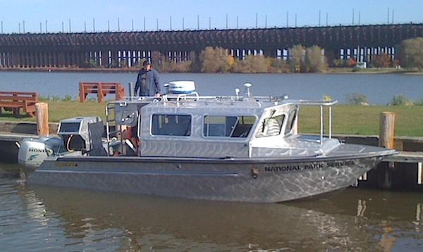
Crews will be mapping the bottom of Lake Superior within the boundaries of Apostle Islands National Lakeshore via this craft/NPS
A 28-foot silver boat gliding about the islands of Apostle Islands National Lakeshore this summer will be working towards completing a mapping of the Lake Superior lakebed around the islands.
'We know a lot about what lives on the islands, but comparatively little about what's under the surface of Lake Superior,' says project leader Jay Glase, a fisheries biologist with the National Park Service in Ashland, Wisconsin. 'We have population information about some species of fish and other organisms, but not much is known about their habitat around the islands. This mapping project will let us see those habitats'some of them in 3D.'
The mapping project was made possible through funding from the Great Lakes Restoration Initiative and began in the fall of 2010. This summer will be the fourth season of mapping in the Apostles.
The idea for the project came out of a national strategy for protecting and maintaining ocean and Great Lakes coastal waters adjacent to National Park Service sites. 'Discover, map, and protect' is one of four major emphasis areas in the NPS Ocean Park Stewardship Strategy, and lake-bottom habitat mapping is identified as a major element. Such maps are the equivalent of topographic maps. When the work is done in the Apostles, park managers and others will be able to look at the lake bottom within the quarter-mile buffer around each of the Apostle Islands and see not only how deep areas are, but also what the bottom looks like.
'This type of mapping helps us to see where docks or other structures may be disrupting lake currents and creating sand deposition areas,' says Julie Van Stappen, chief of planning and resource management at Apostle Islands National Lakeshore. 'It also helps us to monitor the location and condition of shipwrecks, and maybe even to discover new cultural artifacts.'
The mapping is also being done at Isle Royale National Park and Pictured Rocks National Lakeshore, and at Sleeping Bear Dunes National Lakeshore on Lake Michigan.


Add comment