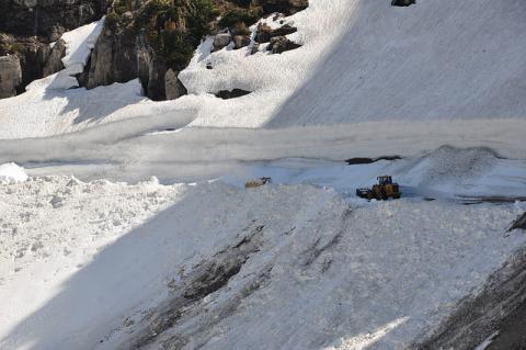
Each year in June, the perennial question for the staff at Glacier National Park is, "When will the Going-to-the-Sun road open?" The route is frequently touted as one of the most scenic in the world, and for good reason, but removing the winter's accumulation of ice and snow from the high mountain road is always an enormous undertaking.
Thanks to a late season storm, that job has gotten a lot tougher this year.
June 21 marks the summer solstice in the Northern Hemisphere, and therefore the "official" start of the summer season...but you'd never know that was the case by looking at all the new snow that fell in the park late last week.
The late spring storm brought four to eight inches of rain to lower elevations and up to 36 inches of snow to higher elevations over a two-day period last week, forcing the temporary closure of a number of park roads, campgrounds and other facilities.
The weather slowed, and in some cases stopped, spring plowing for several days, due to the weather, low visibility and numerous avalanches. West side plowing activities resumed on Sunday and road crews punched through 16 new snow slides to The Slopes area on the Going-to-the-Sun Road.
A park spokesperson reports at least 24 new snow slides on the road were observed by park staff, with more anticipated as plowing progresses. Road crews report encountering snow slides up to 200 feet long and 15 feet deep.
Crews will also be clearing the road of rock, mud, and wood debris. Many areas of the road that were once clear of snow now need to be plowed again. A snow slide destroyed at least eight segments of guard rail near Haystack Creek.
On the west side of the park, Going-to-the-Sun Road is currently open to vehicle travel from the West Entrance to Avalanche. Hiker-biker access is available from Avalanche to the Loop while road crews are working.
On the east side of the park, the Going-to-the-Sun Road is currently open to vehicle travel from St. Mary to Jackson Glacier Overlook. Road construction activity is currently underway between Rising Sun and Siyeh Bend. There is no hiker-biker access past the Jackson Glacier Overlook vehicle closure.
A map at this link shows the portion of the road that's currently open, and that webpage also offers updates on the status of other roads in the park.
Water levels appear to have stabilized across the park, decreasing concerns of flooding. The St. Mary Campground is now open with limited sites available. Access to Kintla Lake via the Inside North Fork Road on the park's west side is again possible, after parts of that road were closed due to high water.
On the park's extreme northern end, the Goat Haunt area is now open and boat tours to that area from Waterton Lakes National Park in Canada are operating regularly. That boat trips were suspended briefly after high water damaged the dock at Goat Haunt.
Park personnel continue to monitor other areas of the park as temperatures rise and snowmelt continues. You'll find information here on the status of efforts to get the Going-to-the-Sun road open for the season, along with other information about that scenic drive on the park website.
The park has not ventured a prediction about the opening date for the road this year; there are simply still too many variables at this point. Last year the road was open all the way to the summit at Logan Pass on June 21, but the 2011 season saw the latest opening in the park's history: July 13. Whatever the date turns out to be for 2014, visitors who make the trip to the top should expect to find plenty of snow on the ground.
Until the Going-to-the-Sun road does open for the season, there's still plenty to see and do in the park. If you're driving between the east and west sides of the park, US 2 skirts the park's southern boundary and connects those two areas. General information about planning a visit to the park is available on the park website. For additional views of snow and high water from the recent storm, you can check out images on the park's Flickr page.


Add comment