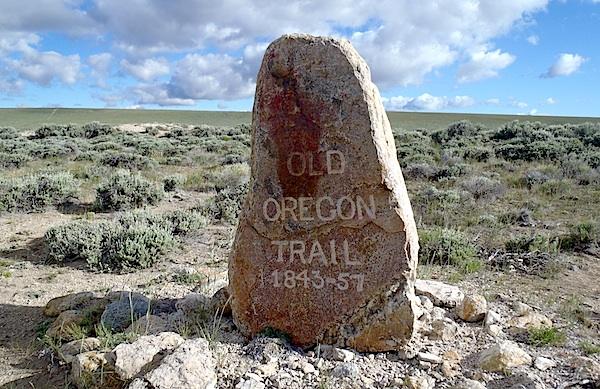
Along the Oregon Trail south of South Pass City, Wyoming/Kurt Repanshek
Plant yourself -- leaning into the wind, of course -- on the open prairie near South Pass City, Wyoming, and you can quickly envision the setting that faced emigrants and their Prairie Schooners more than a century ago in their exodus to the West Coast. Endless miles of sagebrush, the Wind River Range looming ever-present to the north, a boundless sky dotted here and there with distant rainstorms. At your feet, and running to the horizon both east and west, is cut a deep swath of pain and misery, hope and expectations, and beginnings and endings.
There are places along this 2,000-odd-mile route where deep swales riven into the prairie by wagon trains still remain. Though covered with sagebrush and other vegetation, the Oregon Trail is clear to see here and there. Near Guernsey in eastern Wyoming, not far from Fort Laramie National Historic Site, the ruts run deep through sandstone. But here, to the south and west of South Pass City, the prairie has worked hard to reclaim the ruts. Cattle grazing has swept over the trail in places, leaving behind both cattle guards and cowpies.
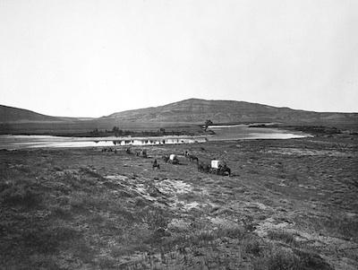
Emigrants on the Oregon Trail near Red Buttes/William Henry Jackson, National Archives
Today the Oregon National Historic Trail is co-managed by the National Park Service and the U.S. Bureau of Land Management. There are plenty of brochures, pamphlets, and maps that you can pick up to learn more about the trail, and to help you retrace parts of it, for quite a bit of the trail in western Wyoming is open to vehicles. But you'll need a high-clearance, four-wheel-drive rig that can tolerate mud and muck and sagebrush and cattle guards that erosion has, in places, left standing 6 inches or so above the trail. A spare tire, plenty of water, and snacks are a good idea, too.
Helping you navigate this dirt route, which obviously is used by ranchers as well as tourists, are concrete posts bearing the names of the trails that passed this way -- Oregon, California, Mormon, and Pony Express -- sunk into the concrete. But retracing the route isn't as simple as it might sound. The route doesn't appear to be kept up by either NPS or BLM, and the BLM topo maps that depict the trail and point to interpretive markers aren't easily followed. In mid-June we found ourselves a mile or so west of Pacific Springs -- named by the pioneers for being the first water flowing west from the Continental Divide -- at a scenic area with some well-weathered placards, trying to find the location of a triple grave. While we knew the general direction to head, the lack of an apparent trail convinced us to put the search off for another day.
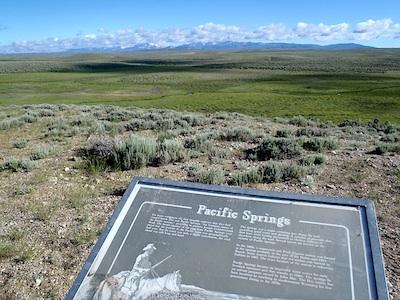
View across Pacific Springs to Wind River Range/Kurt Repanshek
Instead we headed down Wyoming 28 a short distance to a monument marking the False Parting of the Ways and turned down another dirt road that led across the cow-dotted prairie to the Dry Sandy Stage and Pony Express Station. All that remains is the Dry Sandy Creek, a thin stream of brackish water. Not a sign of the stage station or Pony Express station remains.
Before you set out to explore the trail, visit the Oregon National Historic Trail website and either download maps and brochures to help you navigate the trail or email the National Park Service for hard copies. You won't be disappointed.
There are a couple of BLM campgrounds near South Pass if you'd like to spend a couple days exploring not only the historic trail but also the South Pass City Historic Site, which is managed by the state of Wyoming.


Comments
Nobody took a Conestoga wagon down the Oregon Trail in the 1840s and 1850s.
Welllll, you might be right, John. Some sources indicate early emigrants might have tried the Conestoga before realizing it was too big and bulky for the trek. Thus it gave rise to the Prairie Schooner.
That said, I'd agree an edit is needed. Thanks.
The Oregon National Historic Trail is not co-managed by the NPS and the BLM. The NPS is the administering agency charged with implementing the trail Comprehensive Management and Use plan in partnership with other agencies, landowners, states, and other partners. Management responsibility of any place on the trail resides with the owner of a site or segment of the trail. Thus BLM has complete management responsibility for all of the trail on BLM land. Two trails, El Camino Real de Tierra Adentro NHT, and the Old Spanish NHT have actually been assigned to both the NPS and BLM as co-adminstrators. This has been somewhat successful for the Camino Real, but has been a disaster for the Old Spanish Trail as BLM cannot coordinate decision making and budget among the five separate states. While the NPS assigns the trail to a Superintendent with trailwide responsibility, the BLM assigns a lead person who is a low level employee who has no real decision making ability for the trail. Each BLM state director is independent of each other and the trail lead, who is currently in the Utah office. As a result, the Comprehenive Management and Use plan for the trail has not been finalized and sits without approval by the BLM.
Yeah, James Reed of the Donner Party famously used a wagon that was too big and too heavy. At least he was lucky enought to live to regret it.