Public comment is being taken through September 4 on an ORV management plan for Cape Lookout National Seashore/Kurt Repanshek
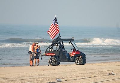
Off-road vehicles would be able to travel most of Cape Lookout National Seashore under a draft management plan, which also would create three "pedestrian only" areas on the seashore.
Though not nearly as controversial as the off-road management plan at Cape Hatteras National Seashore just to the north on the North Carolina coast, the proposed Cape Lookout National Seashore Off-Road Vehicle Management Plan/Environmental Impact Statement aims to put specific numbers to ORV traffic, specify where they can travel, formally set speed limits, and set seasons for when they can travel on the seashore.
Efforts to provide pedestrian only access during the summer months would cause the mileage open to ORVs to seesaw just a bit:
Under the seashore's preferred alternative in the draft plan, 44 of the seashore's 56 miles would be open to ORVs from March 16 "through the Thursday preceding Memorial Day and from the day after Labor Day through December 15." Forty-one of those miles "would be available for ORV use from the Friday proceeding Memorial Day through Labor Day. Routes within the Cape Lookout Village Historic District would be open to through vehicle traffic."
The pedestrian-only areas would include the entire length of the seashore from December 16 through March 15. From March 16 through December 15, pedestrian-only areas would include "Portsmouth Village, an expanded lighthouse beach, and Power Squadron Spit from approximately mile marker 46 to the end of the spit, and all of Shackleford Banks."
Pedestrian-only areas would be expanded during the summer (defined as from the Friday preceeding Memorial Day through Labor Day) would include the following:
* Long Point: On the ocean beach at the Long Point Cabin Camp for a day-use beach and a separate tent camping area for a total pedestrian-only area of about 0.50 miles, to be determined by beach profile.
* Great Island: On the ocean beach at the Great Island Cabin Camp for a day-use beach and a separate tent camping area for a total pedestrian-only area of 1.9 miles, to be determined by beach profile.
* Codds Creek: On the ocean beach near Codds Creek for a total closure of 0.8 miles between ramps 35a and 35b for pedestrians only. Camping would be allowed in this area, except for the north end turtle relocation site.
* Light Station: The pedestrian-only area at the lighthouse would be expanded approximately 0.7 miles to the south and would run from ramp 41a to ramp 42a (at the NOAA weather buoy) for a total closure of about 1.4 miles year-round, to provide visitors at the ferry hub a bigger stretch of vehicle-free beach.
Under the plan, which is open for public comment through September 4, ORV speed limits would be set at 25 mph along the beach and other designated routes, or as posted, and at 15 mph when within 100 feet of any "person, vehicle, campsite, other structure..." There also would be restrictions on night driving from May 1 through September 14 each year "to reduce potential impacts to turtles and bird chicks."
The plan also would allow up to four additional "ramps" that would provide access to the ocean-side of the national seashore from the "back route" on the sound side. And it would continue a prohibition "of all high-performance sport-model and two-stroke ATVs and UTVs (after a five-year grace period) and seasonal restrictions on all other ATVs and UTVs" due to their impacts on shorebirds. According to the draft plan, these vehicles likely flush birds more than other ORVs because of the noise they generate.
Proposed fees for ORV permits range from $80 for a ten-day permit to $150 for an annual permit.
The initial limit on the number of vehicle permits issued would be 2,500 permits annually for the North Core Banks and 3,000 permits annually for the South Core Banks, which is based on the average number of ORVs delivered to each island from 2005 through 2012. A limit on the number of vehicle permits issued per year would be established in year 4 of this ORV management plan/EIS, based on the average number of permits issued per island in years 1'3. Permits would be issued on a first-come, first-served basis. An annual lottery may be established to equitably allocate permits.
As with Cape Hatteras National Seashore, ORV use at Cape Lookout existed long before the national seashore was established. It also was not addressed in the seashore's enabling legislation.
"Beginning in the 1930s, vehicles were transported to the banks by shallow draft ferries and were used to provide access to productive commercial and recreation fishing spots, as well as for other recreational pursuits such as sightseeing and camping. Today, ORVs provide vehicular access to the Seashore beaches for recreational purposes, including activities such as surf-fishing, surfing, sunbathing, swimming, bird-watching, camping, visiting historic structures and site seeing, among other activities," the draft plan notes.
As with Cape Hatteras, sensitive species at Cape Look are driving the ORV guidelines. While some comments collected by the seashore during the planning stages suggested that the park staff move bird or turtle nests and eggs away from ORV corridors, staff said that wouldn't work as piping plovers and American oystercatchers more than likely would abandon their nests under such circumstances.
While turtle nests could be moved without concern for abandonment, "studies indicate that the determination of the hatchling sex ratio depends on the temperature at which the eggs incubate. Changes in these temperatures due to moving the eggs may result in changes to the sex ratio, having implications for the species as a whole. Handling eggs can result in increased hatch failure. When relocating nests, there is a risk of disrupting the membranes inside the egg, which can kill the embryo," the draft EIS notes.
Seashore staff also declined requests to allow for an off-leash area for dogs. While there were requests during the planning stages to include more restrooms, dump stations, and water pumps on the national seashore, park staff said those elements were not central to the off-road vehicle management plan, and so would not be considered at this time.
You can read the entire plan, and comment on it, at this site.


Comments
This just shows how dishonest some are about this issue. You know that ORV regs have slowed down the shoulder seasons, primarily the entire spring. Summer tourism generally has not slowed but certainly a different crowd. You can fool those that don't know, you sound like Audubon when you spout half truths like that.
Its not just ORV groups complaining, but you know that, and would not call those groups the majority either.
You can be certain the "getting in line" at CALO will result in more regulation, more fees, less visitors and hardships on the communities that depended on visitors.
No beachdumb I don't know that at all.They only thing that significantly slows busness down is access on and off the island. I don't like calling people liars but do think you are so caught up in the ORV hysteria that you have tunnel vision. If the road and OI bridge stay sound everything indicates the economy for Hatteras Island in 2014 is going to be excellent.
The majority of the americian people don't want their national seashores beaches turned into parking lots. I have peronally witnessed that transformation take place here because of past management. If you don't understand what I mean by that you are not being truthful.
I've never driven an ORV, and have enjoyed beaches for over 60 years now. I have a feeling that there are enough other people who could make a similar statement sufficient to populate the beaches many thousand times over.
"The more the federal government regulates land that they call "theirs" the better the argument for local control of public lands."
These parks are owned by the federal government. That means they are owned by ALL Americans, not just the small population that lives nearby to them. That population is obviously affected by what goes on in the parks, which is why they get a say in how they're managed. But the parks are not theirs. They are owned by and for the use of all Americans, and people travel from all over the country to make use of our parks there. Local control of these parks makes absolutely no sense.
"Local control means that these bureaucrats are answerable to someone, unlike the NPS who answers to no one but themselves with no oversight. Please create an NPS oversight committee NOW."
Local control might make the bureaucrats more answerable to someone, but it'd make them more answerable to the wrong someone. At any rate, there is oversight of the National Park Service in both the House and the Senate even if there is not a committee specifically named the National Park Service Oversight Committee. If you feel your congressional representatives are not doing a good enough job in providing their appropriate oversight, feel free to give them a call.
Thank you, Ethelred, for your reasoned comments.
But can I make a correction? Everyone has a say in how the park is managed. You don't have to live locally to give your input on a management plan. They are all posted on the web, deep within the bowels of the website that is mentioned in the article.
So please give your input.
Danny www.hikertohiker.com
Ethelred,
No one believes that their input has any sway with the NPS. Public comments are a prime example. There are several examples of times when the NPS has wholescale ignored public input at multiple NPS units. And that isn't just locals or folks who moved into NPS units and make a living off of them by guiding or providing concessions in that unit. The NPS gives more sway to consessionaires than stakeholders. That is the problem. The NPS forgot who their real stakeholders are. Dollar signs. Follow the dollar signs.
" The NPS gives more sway to consessionaires than stakeholders. That is the problem. The NPS forgot who their real stakeholders are. Dollar signs. Follow the dollar signs."
This from someone who habitually complains about the most miniscule of fees, like $2 for a roundtrip shuttle ride to see the fireflies. Sorry, but if your grand conspiracy theory is that the NPC is concerned with nothing but maximizing the profit potential of the National Parks, they sure are doing a terrible job at it.
Buxton, can you cite the source of this claim?
Ethelred, I used to think that was true, until NPS showed us differently. I also agree, unfortunately, we now need an NPS oversight committee.
Ethelred, why? Don't State's control and successfully manage parks and recreation areas already? You can't deny that more and more States are considering this action, the NPS's reluctance do what is right for the people have forced this issue. The NPS better get prepared for this or change.