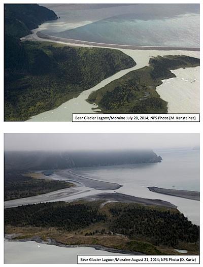
Before and after photos showing breach in the Bear Glacier/NPS photos
Editor's note: The following article was prepared by Deb Kurtz, the natural resources program manager at Kenai Fjords National Park and Preserve in Alaska.
On Friday, August 15th, Kenai Fjords National Park staff received numerous reports that water from Bear Glacier Lagoon had breached the moraine separating the lagoon from the mouth of Resurrection Bay, also referred to as the Harding Gateway. Subsequent reports indicated that water levels peaked in the lagoon on August 14th and breached the moraine on August 15th, resulting in a series of standing waves extending from the moraine almost 2 miles out to Callisto Head and sending a plume of silty water nearly eight miles out to Rugged Island.
As water exited the lagoon through the newly breached outlet, lagoon levels dropped 1-2 ft below normal levels, prompting increased calving activity at the terminus of Bear Glacier. The channel of the previous lagoon outlet was left dry.
This dramatic event is called a glacier lake outburst flood. Glacier lake outburst floods occur when water that has dammed up behind, below, or inside of a glacier is rapidly released. They are not uncommon in Alaska and are known to occur regularly (annually, biennially, or triennially) at several locations on the Kenai Peninsula, including Bear Glacier, Skilak Glacier, and Snow Glacier. During glacier lake outburst floods, down-glacier flooding from water discharged from an ice-dammed lake will increase over a period of a few days followed by a decrease to normal water levels.
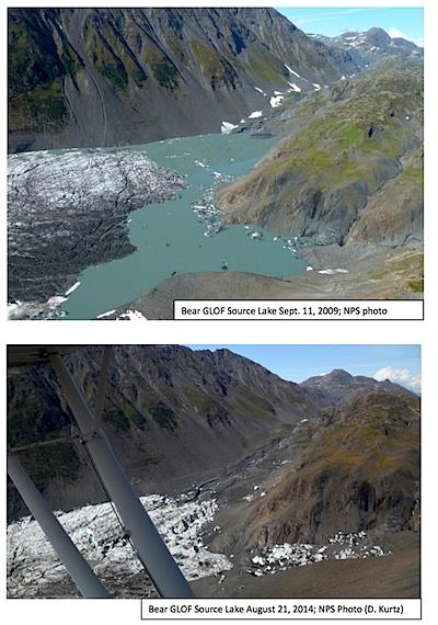
Before and after photos showing draining of Bear Glacier Lagoon/NPS photos
Heavy rainfall during the two weeks preceding the 2014 flood likely contributed to the ice dam failure and greater impact of the downstream flooding. Nearby weather stations reported nearly 5 inches of rain at the Seward airport and on the Harding Icefield and an impressive 20 inches in Aialik Bay. Photos of the drained source lake reveal that the edge of the glacier adjacent to the source lake has retreated in recent years. This may allow the source lake's basin to accumulate and hold a greater quantity of water, making more water available to be released during a flood event.
This winter when temperatures return to freezing, water levels should drop in the lagoon and may provide an opportunity for winter surf to rebuild the breached portion of the moraine. According to a long-time local resident, a similar event occurred in the fall of 1986 when Seward experienced significant flooding. Although flooding in the lower lagoon resulted in a breach in the moraine that fall, winter surf restored the moraine before most people returned to the area the following summer, allowing the event to pass relatively unnoticed.


Add comment