
The past week was an especially busy one for park staff and cooperating agencies at Buffalo National River. Dry winter weather set the stage for four responses to wildfires, including multiple fires on the same day, and just to keep life interesting, those incidents overlapped with a call for help when a rider was injured after a fall from a mule on a backcountry trail.
Buffalo National River is a long, linear park, with over 95,000 acres spead along 135 miles of the river as it winds its way through rugged cliffs and heavily wooded hills and valleys in the Arkansas Ozarks. The park is divided administratively into three districts, running from west to east, dubbed the Upper, Middle and Lower Buffalo. When emergencies occur, personnel from all three districts are often needed.
Resources from throughout the park, along with those from neighboring agencies, were certainly tested during the past week.
On Sunday, January 18, the "Baker's Dozen" wildfire started from debris burning which escaped control near the small town of Gilbert, just outside the Middle Buffalo District. Personnel from the park, Arkansas Forestry Commission, and Pindall, Gilbert, and St. Joe Rural Fire Departments responded to this fire, which burned about 80 acres before it was contained.
While work on the Baker's Dozen fire was still underway, park dispatch received a report of a second wildfire in the vicinity of Jackson Ridge in the Lower Buffalo Wilderness. This area is on the south side of the Buffalo River and the perimeter of the wilderness area has very limited access via public roads.
Some NPS assets remained with the Baker's Dozen fire, but most were transferred to the Jackson Ridge Fire. This fire was estimated at about 20 acres at the time of the initial report, but had doubled by nightfall. There was ample reason for concern about further rapid growth due to low humidity, gusty winds, unseasonably high daytime temperatures, and a high fuel load, part of which resulted from downed limbs and trees from a major ice storm which hit the area in 2009.
On Monday, January 19, while work continued on the Jackson Ridge Fire, personnel from the park, Arkansas Forestry Commission and Ralph-Caney Rural Fire Department responded to the "Tony Bend" wildfire adjacent to the Lower Buffalo District, but on the opposite side of the Buffalo River from the Jackson Ridge Fire.
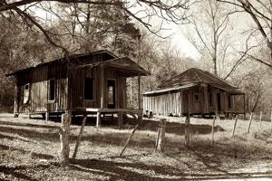
Historic structures, such as these in this 2011 photo of the Rush Ghost Town, are always a concern when wildfires occur in the vicinity. Photo by Doug Wertman via Creative Commons.
Threats from this fire included private residences, the historic ghost town of Rush, and several NPS buildings, along with a section of the Lower Buffalo Wilderness area. The fire was declared 100% contained the following day, with the burned area estimated at 175 acres of both private and NPS lands.
Two additional fires in recent days further stretched area resources, including the "Gobblers' Knob Private Rx" fire adjacent to the Middle Buffalo district. NPS staff located the fire in the Silver Hill area near U. S. Highway 65, and fire resources from the Marshall, Pindall, Gilbert and St. Joe Rural Fire Departments responded before Searcy County dispatch advised the fire was a controlled burn on private lands. The fire was near the park boundary, so was monitored by park personnel until it no longer posed a threat to NPS land.
Finally, the "Blue Ribbon Road" wildfire, again near the park's Middle Buffalo District, threatened structures including one NPS house and a private farm house, outbuildings, farm equipment, and livestock. This fire burned about 693 acres before it was contained by resources from the U.S. Forest Service, Arkansas Forestry Commission, and the Pindall, St Joe, and Gilbert Rural Fire Departments.
By Thursday, January 21, all four fires were listed as 100% contained. The "Jackson Ridge Fire" had a final control size of 1,300 acres, but continued to burn in stumps and in down and dead fuels within the control zone for several days. Twelve persons were assigned to this fire from the NPS, Arkansas Game and Fish Commission, and USFS 'Sylamore District Ozark NF; by later in the week, staffing was scaled back to two personnel to patrol the perimeter and monitor hotspots.
And. ...just to keep life interesting in the midst of the uptick in wildfires, rangers in the Upper Buffalo River received a report on Tuesday, January 20 of a woman with an injury three miles downstream from Steel Creek on the Old River Trail.
Rangers responded to the Steel Creek area, located a horseback rider who was a member of the injured person's party, and learned that the victim had been thrown from a mule. A ranger accompanied the reporting party down Old River Trail on horseback and located the patient a short distance past the Beech Creek Horse Trail junction.
Emergency care was provided by the ranger until a litter team arrived on foot. The patient was loaded in the litter and evacuated back up Old River Trail to a waiting ambulance at Steel Creek, and then transported to North Arkansas Regional Medical Center (NARMC). A total of 23 responders assisted in the incident, including personnel from the park, Mennonite Disaster Services, Newton County Search and Rescue, NARMC, and the Carroll County SAR Team.
A park spokesperson notes that during the week, more than 800 "person-hours" were devoted to the four fires, with additional time required for the backcountry rescue. These incidents illustrate the critical importance of cooperation between the park and other federal, state, local and volunteer agencies in fire, SAR and other emergency situations.


Add comment