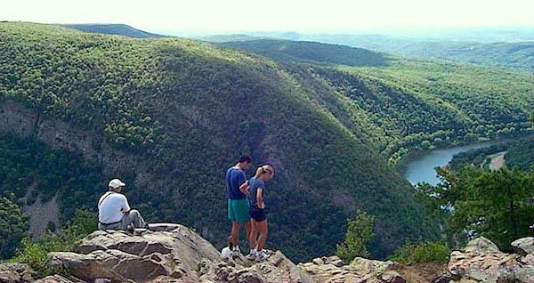
The Water Gap as seen from Mount Tammany in New Jersey/NPS
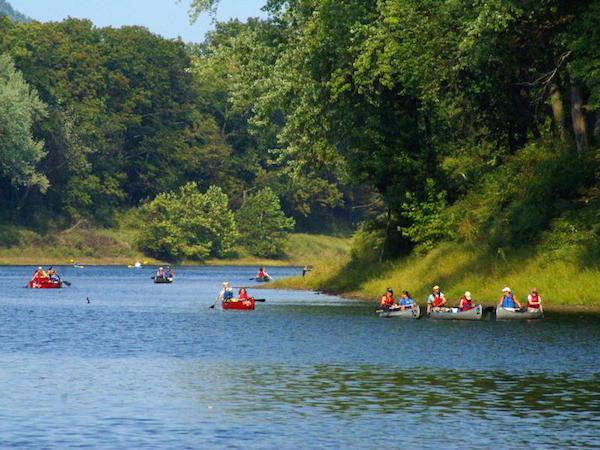
Located roughly midway between New York City and Philadelphia, the Delaware Water Gap National Recreation Area is a verdant, mountainous oasis cut by a cooling river that attracts millions every year, with most coming during the summer months to relax and gain a bit of respite from the region's notorious humidity.
Those millions, though, can be oppressive when squeezed too closely together. They also can be tough on the landscape, particularly when word spreads across the Internet about an idyllic spot that one day attracts 10-20 visitors, and the next 100-200 as word spreads.
"We're celebrating our 50th anniversary, so we have 50 years' experience with trying to essentially trying to provide everything for everybody. We realized that we have to be more focused in what we try to do for the public in this location," Superintendent John Donahue said during a recent conversation. "I think the visitor use management plan that we're undertaking is going to look at what we've learned since the creation of the park in 1965 and since the general management plan was done more than 30 years ago. It's also going to address issues that are coming up in the modern world that didn't exist then."
The result could be restrictions on where visitors can go and when.
'We get an awful lot of response to things that are said on the Internet. Somebody or some organization posts advice to people to go to a particular pond or stream or waterfall and conduct activities which are not allowed," Superintendent Donahue said. 'But all it takes is a posting and you go from 15 visitors on Saturday to 250 on Sunday and a thousand the next week. So we're trying to look at how to manage the uses in a way that provides the greatest amount of opportunities while still protecting park resources. But maybe everything doesn't have to be allowed in every place or in every time of the year.
"I think that when you're dealing with 4-5 million people coming to enjoy the park you need to set up parameters that allow them to enjoy their experience in the best way possible.'
A Recreational Oasis
Wrapping 40 miles of the Middle Delaware National Scenic and Recreational River that is the boundary between Pennsylvania and New Jersey with roughly 70,000 acres of bucolic landscape, the NRA was authorized in September 1965. At first, the prospect of a dam, the Tocks Island Dam, had legislators thinking a national recreation area touching the resulting reservoir would make a perfect recreational destination for one of the most crowded and urbanized regions of the country.
While that dam later was deauthorized by Congress, lands that had been set aside for it were transferred to the Interior Department for the NRA in 1978. About the same time the Delaware River that flows through the region was declared a "scenic and recreational river" under the Wild and Scenic Rivers Act.
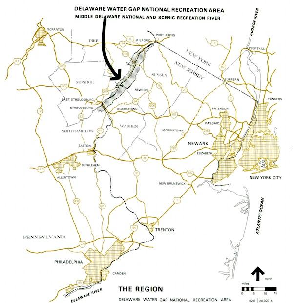
With its location midway between New York City and Philadelphia, Delaware Water Gap NRA gets a lot of visitation/NPS
Rife with waterfalls, forests threaded with hiking trails, including a segment of the Appalachian National Scenic Trail, and pastoral settings, the NRA also is rich in history and pre-history. Evidence of more than 10,000 years of continuous human habitation is scattered throughout the NRA, Millbrook Village contains buildings dating to an 1800s village, and some other buildings in the NRA date to the 18th and 19th centuries.
Trying to manage those resources in a 21st century setting is not always easy, particularly not with limited resources, noted Superintendent Donahue.
'The reality of Delaware Water Gap NRA is that we are one of the biggest infrastructure parks in the system," he said. "I think there are eight parks altogether including us that contain about 60 percent of the infrastructure of the entire National Park System. Most of those other parks have larger operational budgets than we do. Right now we're operating at about $9.5 million, operational budget, and not only do we have close to 200 miles of roads, but 22 miles of Route 209, for example; it's the main road in this area for people to get anywhere."
Along with those miles of highway that need to be plowed in winter and repaired in summer, the NRA is also responsible for more than 700 structures, many of which are historic and date to the eighteenth and nineteenth centuries.
While the general management plan that was adopted for the NRA in 1987 provided guidance for maintaining those facilities and managing visitors, that document doesn't do a great job of protecting resources today.
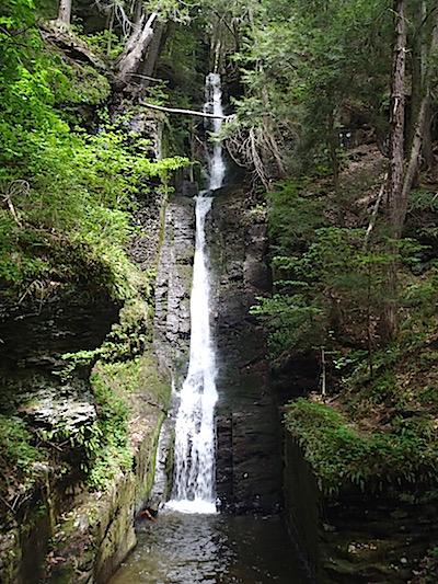
Silverthread Falls doesn't get as much recognition as Dingmans Falls, but it's just as beautiful/Kurt Repanshek
"The general management plan, as it exists, has a lot of really good stuff in it, but it's 30 years old," said Superintendent Donahue.
While the document identifies critical resources, such as exceptional natural resources, it doesn't contain parameters dictating how those resources can be managed. "There's nothing that says you can't do anything here that you would do somewhere else," he said.
The visitor management plan, as envisioned, strives to correct some of the shortfalls by managing visitation use while balancing resource protection, he said.
Part of better management is a better understanding of what visitors want. To that point, the park is expected to be conducting visitor surveys this summer.
'What we're finding, is that there's a tremendous interest in the Water Gap, especially on the New Jersey side," said Oliver Spellman, the senior program manager for the National Parks Conservation Association's Northeast regional office. "So I think taking a survey of the visitors and what their favorite activities are is good short- and long-term for the park.'
Drawing from such a large geographic area, he continued, makes it vital for the park staff to understand its visitor base. On the New Jersey side, said Spellman, there's keen interest in seeing more water access points.
Of course, better managing visitors might also require more, or increased, fees. As with Great Smoky Mountains National Park to the south in North Carolina and Tennessee, there is no entrance fee to visit Delaware Water Gap NRA. Indeed, there aren't many fees the park can collect to help meet its costs. Entrance fees and expanded amenity fees are two very different things. The Water Gap does not charge an entrance fee but it does collect an expanded amenity fee at six sites, including three beaches, boat launches and a picnic area.
'We're in a very difficult position compared to other parks when it comes to collecting fees. We're a linear park, we have 42 miles of river, about an equal amount of land on each side of the park," Superintendent Donahue explained. "'We collect expanded amenity fees now at six locations including boat launches, three beaches, and some picnic areas.'
'But the park largely is free to enter and use. It would be very difficult to set up a system where you would charge entrance fees. We have more than 80 legitimate entrances into the park, and we don't own all of the roads. We have town roads, county roads, state roads, that essentially cross our roads. So it would be very difficult to create an entrance fee," he said. 'Right now, you pay $7 during the week and $10 on the weekend day to be able to use any or all of the amenities at our fee areas all day long. You can also buy a season pass to make it an even better value.
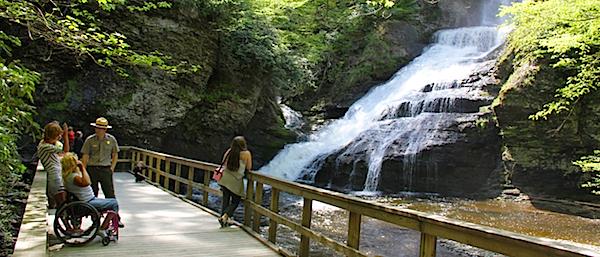
Dingmans Falls is a key destination for many visitors/NPS
'So I do think in able to sustain those amenities, the way the laws are set up now, user fees are an even better deal. But they're never going to provide a large portion of the overall operating costs," he said.
A Goal Of Sustainability
The end goal, Superintendent Donahue said, is to not only provide the best experience possible without trampling park resources, but also making the NRA more "sustainable," from both an ecological and environmental standpoint While continuing to be a strong economic driver in local communities.
"To be sustainable, something has to be sustainable economically. So you can't create a vision for things that you can't afford to build or, more importantly, to operate after you've built them," he explained. "So I think on the one hand we're looking to create a workforce and a vision for the park that's sustainable economically into the future, for the next 50 or 100 years. And also to try to make sure that everything we do, all of our actions on behalf of the National Park Service, are environmentally sustainable. We look at everything from the kind of paper we buy to our recycling program to larger environmental issues such as reducing our carbon footprint to make sure that we do things in an environmentally sound way."
In light of the hundreds of structures, one way to sustain them and make them economical would be to lease them out, the superintendent said. Such use is permitted under the 1987 GMP. Going forward, a Historic Properties Management Plan is currently being developed to guide the park in managing some of the structures. The HPMP will also examine potential uses for the buildings, which could include leasing, use by partner organizations, education and interpretation, or other options.
'So what we want to do with the historic properties management plan is establish priorities. Hopefully it will result in some kind of tiered system where there are buildings that are being completely restored for a specific purpose," he said. "Whether that purpose is to be rented out, leased out for business, residence, non-profit organizations, those things need to be established, because we do have some money with the mitigation fund, but it's certainly not an amount of money that's going to be able to address all of the buildings and structures that we have."
The mitigation fund the superintendent referred to is a $66 million fund set up after the Interior Department permitted a transmission corridor to be enlarged through the NRA. That fund will help pay for wetlands mitigation, land acquisition, stewardship projects, and cultural resource management projects, including the HPMP.
For now, the park staff is working to develop the visitor management plan, which is expected to be finalized in 2017. You can follow its progress on this website, and by following Delaware Water Gap's Facebook page.


Comments
A title change; away from recreation area to National Park may instigate a different mind set. Nothing to lose. Congress should wake up and provide more funding for LE personal. Signs are also important shy of having Rangers present; No Littering for example, or no camping no fires. Would think too much goes for road repairs and trash removal, litter abatement is another story. Needs not wants, unimpaired for future generations. The bears need a break as the density is down, this resource need be shared and not dominated by hunters.