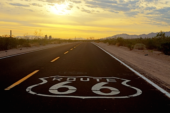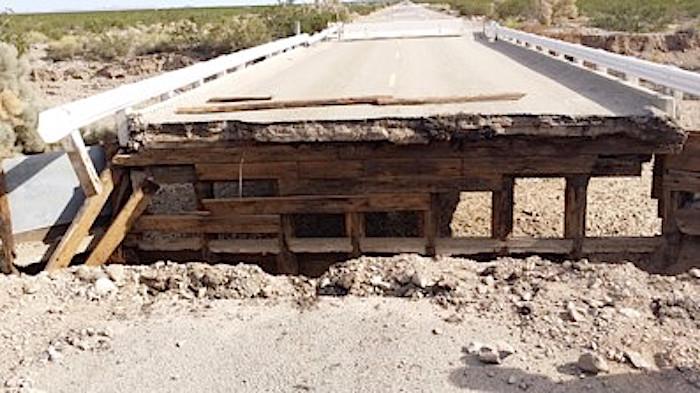
Route 66, America's "Mother Road," runs through the heart of the proposed Mojave Trails National Monument, but is in dire need of maintenance/San Bernardino County
If California's senior senator, Dianne Feinstein, has her way, Congress will finally vote on a new national monument encompassing 965,000 acres in the Mojave Desert. Other preservation measures are also planned. Lying roughly between the Mojave National Preserve and Joshua Tree National Park, this particular monument would in effect round out the California Desert Protection Act of 1994.
To be called Mojave Trails, its heart would be a 105-mile segment of former U.S. Route 66. Now a county highway west of Needles, California, the critical segment ends approaching Barstow. No two-lane, paved highway in America is more significant; after all, this is America’s Mother Road. Beginning in the 1920s, millions resettling to California followed it west, as have millions of tourists ever since.
This is to explain the problem with Senator Feinstein’s proposal.
These days, historic Route 66 (also called the National Trails Highway) is indeed little better than a “trail.” Ever since losing its federal status, it has received only minimal, sporadic repairs. Finally, a series of washouts early last September tore several key bridges apart. Whole sections of the road were further covered with mud and debris. Initially pegged at $1.5 million, the repairs were expected to take two months. The work then ground to a halt on the insistence that three of the bridges needed to be replaced. Consequently, that half of the road—essentially midway between Needles and Barstow—remains closed.
“You’re kidding,” I said to myself, hoping to drive the entire segment in mid-June. But there it was—an imposing barricade, allowing access just for local residents. “They’ll fine you $600 if they catch you going around the barricade,” one bystander warned me.
Still, I decided to take the risk. Typical of desert washouts, a bulldozer had carved a temporary bypass. So much for a deliberative environmental study, allegedly a primary reason for the delayed repairs.
I then asked for an opinion about the repairs from the attendant at Roy’s Motel and Café, a popular tourist spot down the road at Amboy.
“They just keep making excuses,” he replied. “You know what I think? They’ve decided to abandon the road entirely.”
Fortunately for Roy’s, it further straddles the north/south route linking Interstate 40 and Twentynine Palms Marine Corps Base. Business between both is always brisk. He meant the east/west highway—the public’s favorite—historic Route 66.
“Probably the county is broke and waiting for Senator Feinstein to come up with the money to make the repairs,” I said.
Indeed, when later I checked, the county’s website confirmed that it needs federal dollars, some of which allegedly have been obtained.

Getting funding to pay for fixing washed-out bridges along Route 66 is lacking/San Bernardino County
That would be San Bernardino County, the nation’s largest county by area, in which all of the new monument would lie. The problem is: Rebuilding the bridges has not even started yet; no one knows when the road will fully reopen.
“That’s nuts,” I thought. “Given the tourist dollars the highway generates, it should have been reopened as originally planned—two months tops.”
Meanwhile, tourists have no choice but to take Interstate 40. However, sightseeing on the Interstate is risky business, lest you be run down by a line of trucks. Either that or a truck will force you onto the shoulder while swinging out to pass a slower rig. Trucks do that in California—leapfrog into the left lane the moment you start to pass. On top of the trucks, California drivers have a bad habit of tailgating. I personally consider Interstate 40 a deathtrap and try avoiding it like the plague.
Besides, the scenery and history are on Route 66. It is also parallel to the Burlington Northern Santa Fe Railway, today’s successor to the legendary Santa Fe Railway that developed the South Rim of Grand Canyon. Trains now up to two miles in length zip across the desert floor at 65 mph plus. They’re as much fun to watch as the changing light patterns playing off the mountains near and far.
The point is that drivers are fascinated by both the scenery and the history, including hundreds of thousands of tourists from abroad. Germany appears to send the most. Certainly, the Germans I have met absolutely love the road, which is so unlike crowded Europe. Whole clubs have formed around antique cars and motorcycles meant to recreate American life in the 1960s. Club members fly to the United States after shipping their vehicles to some East or West Coast port. After reuniting with their precious cargo on the docks, everyone heads straight for historic Route 66.

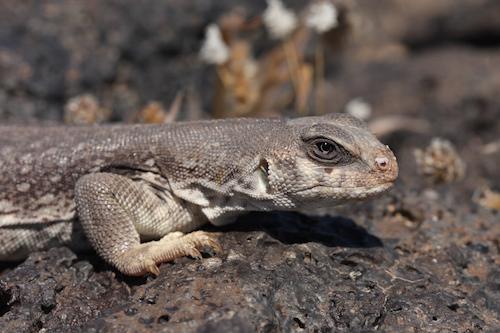
Desert iguanas are some of the wildlife that roams the proposed Mojave Trails National Monument/David Lamfrom
Senator Feinstein is right. The desert landscape alone is of national park-caliber, and should have been included in the original California Desert Protection Act 21 years ago. However, the congressman representing the district was opposed. It was amazing that Congress preserved as much as it did. Equally amazing, the National Park Service gained control over Kelso Depot, the elegant wayside of the Union Pacific Railroad running through the Mojave National Preserve to the north.
Long before the depot’s restoration in 2006, my wife Christine and I were regular visitors, then to wonder whether the depot would survive—and how. Now we wonder the same about Route 66. The longer it remains closed the more the bureaucrats can say it is no longer needed. Tourists can take Interstate 40 and play bumper tag with the trucks.
San Bernardino County insists that is not the case. Rather history is partly to blame—along with those confounded environmental impact statements everyone these days is “forced” to write.
“These bridges are timber and were constructed in the 1930s,” notes Brendon Biggs, deputy director of public works.
Fine; we all get it. The replacement bridges should be historically and environmentally compatible. But how is that any excuse to delay fixing the road for months—and now possibly even years?
The county had to know washouts would happen at some point; serious thunderstorms occur every summer. Why couldn’t county officials have been ready to make a permanent repair—up to and including a historically compatible design—the minute a bridge washed out?
One suspects the answer to that—as with every government agency these days—is money. The funds needed went somewhere else. For that matter, not only is the county broke; the state and federal government are also broke. In the past, powerful U.S. senators got their way—and most certainly got their way on rebuilding roads. Now it would appear that everyone—including Senator Feinstein—is waiting for the monument to be approved.
But will it be approved? If not, she insists she will ask President Barack Obama to intervene using his executive powers under the Antiquities Act. That would work for the land, but what about the road? Tourists are still coming with or without the monument. Is this to be the new America—plead poverty and keep pointing fingers until our entire infrastructure just falls apart?
If the repairs seem expensive today, how does Senator Feinstein expect to afford them later? Perhaps hoping to bypass the Park Service’s alleged $11.5 billion backlog, Mojave Trails would go to BLM. In that case, it is likely Route 66 would stay with San Bernardino County, and what is more, add to the confusion of what is the difference between a national park and a national monument.
Why indeed BLM, when immediately north and south of Mojave Trails the land manager is the NPS? Well do I remember this. BLM did absolutely nothing to protect and/or restore Kelso Depot. Only when the Park Service acquired the station was it meticulously studied and ultimately saved. Will BLM protect Route 66? If there is even a shred of doubt, I say the Park Service should have Mojave Trails—or at least that portion of the national monument requiring preservation of the highway.
Meanwhile, the road is still split in two. If this were Germany or Switzerland, I kept telling myself last month, it would have been up and running within a week. But then, Europe makes no excuses when its roads (and railroads) go down. There (sans Greece, perhaps), people still expect discipline from government. Only America makes the frivolous argument that the “environment” stands in the way (forget the bulldozers carving bypasses), when what really stands in the way is a bureaucracy eating up all the funds with “studies” and “consultants.”
Senator Feinstein needs to clear the air. Although her monument is a worthy project, the ifs here are doubly worrisome. If the Park Service cannot afford it, how is it any different at BLM? If BLM is not committed to historic preservation, how will that ever change in this monument? Especially here, access to the monument is everything. Route 66 needs to be a priority, not just an afterthought. Along with side roads and other historical alignments, its renovation is long overdue.
San Bernardino County admits it can never do that without a significant infusion of federal funds. Why not just give those funds to the Park Service and be done with it? Probably San Bernardino County would stand up and cheer. Yes, you take care of the road.
As for BLM, they don’t do parks very well. One day, the nation will have to decide. If indeed a national monument is actually a national park in waiting, why wait to have it managed by the NPS?
All I know is that I wanted to drive the road last month, and no one seemed to be in charge. You fix the road. No, you fix it. But yes, perhaps we should do another study. Does that sound like the country we grew up in?
Rather, when I was in high school and college, Californians were proud to say that as we go, so goes the nation. In that case, Route 66 is an even bigger wakeup call. When every level of government fails a public treasure like the Mother Road, it is reasonable, however painful, to admit that the nation is finally out of gas.


Comments
This is just the craziest thing! I remember traveling Route 66 just because that's the road we always took to go back East. 40 was already there, but we always wanted the scenic route. We love Route 66! They need to get their priorities straight. Millions of tourist dollars are aimed for Route 66 each year. Please fix this now!
Excellent article by a leading scholar of the history of NPS.
Wonderful article from Dr. Runte. I just wonder where all the money went for road, highway and other infrastructure repair across the country?
There are almost 2448 miles of Route 66 alignments that can be driven from Chicago to Santa Monica. Focusing only on this segment in the desert ignores the broader needs for historic preservation along the road. Granted it is a lovely section, but it needs to be considered in perspective.
For the last 15 years, the National Park Service's Route 66 Corridor Preservation Program has been providing cost share grants for historic preservation and other projects along the entire route. Over $1,800,000 federal dollars have been leveraged against many more non-federal dollars. This program will sunset at then end of FY2019. Resource surveys have been completed over much of the road and many sites and road segments have been added to the National Register of Historic Places.
In November of 2013, the World Monuments Fund, with help from American Express, held a strategic roundtable leading to consider Route 66 The Road Ahead (http://www.wmf.org/event/route-66-road-ahead). From this meeting, a steering committee was formed that is exploring the formation of a national organization to preserve and promote all of Route 66. Over the last two weeks, representatives of the steering committee held a series of public meetings along the road to get public reaction to the proposal. Also being considered in the meeting was public interest in the designation of all of Route 66 as a National Historic Trail to replace the Corridor Preservation Program when it sunsets.
The Mojave section of Route 66 is lovely, but it will have limited tourism impact compared to many ofher sections of the highway, The bridges need to be fixed, but transferring the cost of road maintenance of this section to the federal government needs to be carefully weighed. There are over 200 historic bridges along this road segment. The county has repaired many of them and is working with the State Historic Preservation Office and Caltrans to find ways to repair the bridges taking into account both historic preservation needs and cost. Only one section of the entire Mojave segment of Route 66 is now closed. It is possible to access 66 from I40 via Kelbaker Road, which is also the main entrance road into the Mojave National Preserve. I was just there a few days ago, and if the state would put up better signage, Route 66 tourists could easily be detoured around the closed section until repairs could be made. This would still allow access to the very few businesses still operating along the desert section of 66, such as Roys and the Bagdad Cafe.
The World Monuments Fund also partnered with the NPS and Rutgers University to conduct an economic impact study of Route 66, from end to end. A link to that study can be found at the website above. Funding was provided by American Express.
The current legislation does not, and probably should not, transfer the cost of road maintenance of this desert section of 66 to the federal government. The monument is a good idea and should be established, but the impact of a program to help preserve and promote all of Route 66 will have much greater tourism and economic benefits.
I agree, Grizz, but you still haven't answered the $64,000 question. Why is the road not fixed? You talk about studies and initiatives, but none of that is getting the road fixed--either in California or the rest of the route. This is government today--studies, roundtables, initiatives, and excuses. Sure, you can access Historic Route 66 via the Kelbaker Road "detour," but that still forces you to take Interstate 40, which is nothing but a pile of dangerous trucks. As for what parts of the route will generate more tourist income--when and if they are ever fixed properly--that isn't helping anyone now.
If San Bernardino County, Caltrans, etc., etc., can't do the job. what does this say about our country? A big piece of California's tourist economy went down a year ago, and no one seems to care--care enough, that is, to reopen the road by repairing a few bridges barely 50 feet in length. Think if the San Andreas Fault ruptures in Palm Springs. It's decades overdue. These same people will then do what--study it to death?
I can't answer why the road has not yet been fixed, except to speculate that it is a cost issue. You have to ask the county. I would suggest that a better option than having the NPS or BLM take over road maintenance, is to have Congress pass a healthy transportation bill that would provide funding for such repairs. The proposed monument can protect some very significant natural and cultural resources in the Mojave, but saddling it with the cost of maintaining the highway is not, in my opinion, the best use of limited agency funding.
The studies and initiatives I am talking about have nothing to do with government. They are a private sector movement to promote preservation and promotion of Route 66 from end to end, as currently the efforts of state Route 66 Associations are fragmented. There is a lot of potential along 66 for significant non-federal fundraising at the national level--a potential that the state organizations cannot access effectively. I just visited a number of places along 66 from Springfield, IL to San Bernardino, and like every time I make a trip on the road, there are new closures of historic businesses. The latest to fall was the Dairy Best in Clinton, OK, the best onion burgers on the road.
Good points. As you say, so much of the road's preservation has been a private-sector effort. Did you ever know Bob Waldmire at Hackberry, Arizona, 25 miles east of Kingman? He ran a Route 66 museum there, at the edge of Crozier Canyon. And then the rock quarrying began. He tried to stop it, and I tried to help, even getting Sunset Magazine to write an article, but again--the government stepped in too late. Now one of the most beautiful canyons on the road has been turned into a gravel pit. Bob sold his museum and has since passed away. He was heartbroken about the whole thing.
The powers-that-be are not what they used to be. I keep wondering why Senator Feinstein--if she wants this monument--did not immediately insist that the road be reopened. Perhaps she did, but wanted more to blame the Republicans for stalling the Highway bill. They're all stalling, is the point of my article. Here in Seattle, the city and state went against every recommendation not to build the Waterfront Tunnel--did it anyway--and now are hundreds of millions in arrears. It will be billions before they're done. Geology? What's that?
So you will understand my reaction facing those barricades on Route 66. They symbolize an even greater washout--the death of American government.
Here is an article about the county and fixing the road: http://highdesertdaily.com/2015/06/lovingood-backs-route-66-restoration-...
I never met Bob, but know his reputation well. His bus is now on display in Pontiac, IL.
Just drove past Hackberry last week and the damage from the rock quarries is worse than ever. And as you know, but others on this forum may not, may of those quarries are destroying Hualapai burial sites.