This recent video shows the simmering and sputtering that goes on with the Kilauea Volcano's Summit Vent Lava Lake/USGS
Have you ever seen the Kīlauea Volcano upclose at Hawai'i Volcanoes National Park? This U.S. Geological Survey video footage allows you to do just that.
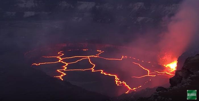
This high-definition aerial and ground b-roll of the Kīlauea Volcano Halemaʻumaʻu Crater Summit Vent Lava Lake was taken between July 24 and July 31, 2016. To know exactly what you're looking at, here's the shotlist provided by USGS:
00:11 Kīlauea summit lava lake spatter, night, medium shot
00:33 Lava lake spatter, night medium shot
00:43 Lava lake wide shot, night, spatter on right of frame
1:01 Wide shot, Evening pan right to left Halemaʻumaʻu Crater to lava lake, with Mauna Loa in background
1:26 Helicopter aerial early morning, half of Halemaʻumaʻu Crater and lava lake
1:44 Helicopter aerial early morning, medium shot, lava lake passing over Halemaʻumaʻu Crater rim and gas plume
1:54 Summit Lava lake surface, evening, seams of incandescent lava exposed as dark-colored crust pulls apart
2:10 Helicopter aerial Halemaʻumaʻu Crater with lava lake inside
2:24 Halemaʻumaʻu Crater telephoto from above rim, gas plume
2:31 Halemaʻumaʻu Day, pan to lava lake
2:59 Lava spatter in lava lake, close up, day
3:21 Lava lake surface, day, black, large lava bubble surfaces
3:40 Lava lake surface, day, silver lava crust, (tectonic plate-analogs) stretch across surface
3:54 Helicopter aerial, day, lava lake most of screen
4:02 Helicopter aerial, night, lava lake most of screen too
4:10 Lava lake full screen, night and gas plume and spatter on edge
4:20 Hawaiʻi Volcanoes National Park sign
4:28 Hawaiian Volcano Observatory (HVO), U.S. Geological Survey Sign
4:40 HVO building shot, crater gas plume behind
4:47 Tina Neal, USGS, addressing assembled USGS HVO employees
4:59 Don Swanson, USGS, on edge of Halemaʻumaʻu Crater rim measuring lava lake surface height with instrument, gas plume behind
5:10 Pan Halemaʻumaʻu Crater Rim, web cam to Don Swanson, USGS, measuring
5:20 Don Swanson, USGS, measuring
5:28 Don Swanson, USGS, writing in a field notebook
5:44 Jeff Sutton, USGS, writing in notebook in field
5:53 Jeff Sutton, USGS, medium, writing in notebook then gets up and looks down instrument into lava lake
6:12 Lava spatter day, veil of gas obscures shot
6:21 Matt Patrick, USGS, in field, silhouette walking by gear
6:34 Matt Patrick, USGS, walking past camera toward over look into crater
6:45 Matt Patrick, USGS, at web cam at crater rim, grabs measuring instrument and looks into lava lake
7:02 Matt Patrick, USGS, close up face looking through lake level measuring device
7:11 Matt Patrick, USGS, medium shot pulls out note book
7:23 Matt Patrick, USGS, close up writing tilts up to face
7:30 Pan web cam to other instrument overlooking lava lake
7:44 3 USGS scientists approach helicopter
7:49 USGS Scientists walk around helicopter
7:55 Helicopter takes off
8:11 Helicopter aerial, scientists in field in lava area, tilts up to show orange glow in skylight
8:24 USGS scientists in mission control area of HVO observing seismic readouts
8:29 Close up Map screen and seismic readouts
8:37 Close up USGS scientists’ hands and note book
8:41 Same USGS scientists from behind
8:52 Thomas A. Jaggar Museum, Hawaiʻi Volcanoes National Park Sign and people
8:59 Jaggar Museum entry
9:10 Jaggar Museum lookout area
9:17 NPS Volunteer close up shot presenting to crowd
9:28 Lava lake spatter, day, gas plume covers end of shot
10:05 Lava lake spatter night close up
10:38 Lava lake spatter night wide shot
10:58 Helicopter aerial, wide shot, shows USGS Hawaiian Volcano Observatory and NPS Jaggar Museum, Kīlauea Volcano summit caldera rim, and all of Halemaʻumaʻu Crater (within caldera), summit vent lava lake within Halemaʻumaʻu, and gas plume
11:11 End title


Add comment