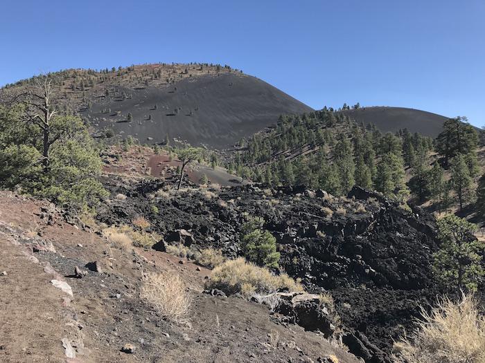
Sunset Crater Volcano National Monument in Arizona/Jim Stratton
I grew up in Oregon in the shadow of the Ring of Fire (not the Johnny Cash song). It is a gigantic horseshoe of volcanos stretching up the west coast of North and South America to Alaska (where I live now), out the Aleutian chain to Russia, and south to Japan and the Philippines – ringing the Pacific ocean. I was dusted with ash when Mount Saint Helens blew, and I hiked in Cascade mountain wilderness areas named for volcanos – Mt. Washington, Mt. Jefferson and Three Sisters.
As a child, I traveled with my grandparents to see the grandest of them all – Crater Lake, the caldera of ancient Mount Mazama and Oregon’s only national park. Volcanos are part of my life and are integral to the landscape of the West Coast and Alaska. So when my quest to visit all the national park units took me to Sunset Crater Volcano National Monument in Arizona and Capulin Volcano National Monument in New Mexico, I was fascinated to learn about some non-Ring of Fire volcanos in the American Southwest.
My girlfriend Craig and I visited Sunset Crater, located about 15 miles north of Flagstaff, Arizona, off U.S. 89 on a sunny October day. We were traveling with our camp trailer and thought we’d park it at Bonito, a U.S. Forest Service campground a couple miles from Sunset’s visitor center. Unfortunately it was closed, the operating months being “late spring through early fall.” There were plenty of RVs cruising the highway looking for a place to spend the night, but some budget cruncher at the Forest Service decided that closing campgrounds in September was the “best management practice.” Bummer for us, as we ended up at a semi-urban KOA in Flagstaff, not our first choice of a place to spend the night. But we got a shower out of the deal and were up and out early the next morning to the visitor center where we learned why there are volcanos in Arizona.
It seems there is some kind of localized “hot spot” deep within the Earth in this part of northern Arizona. As the massive North American Plate moved slowly over the "hot spot," periodic eruptions over the past 6 million years pushed through the plate and created a string of volcanos stretching about 50 miles east from Williams, Arizona, to Sunset Crater, the youngest volcano in the San Francisco Volcanic Field. There are over 600 identified volcanos in the field, named after its largest, San Francisco Peak.
The National Park Service was tasked by President Herbert Hoover with protecting Sunset Crater after a Hollywood film company proposed blowing up one side of the crater to create a rock landslide for a Zane Grey movie titled Avalanche, a silent movie of which a copy no longer exists. Local outcry stopped the explosion and led to President Hoover using the Antiquities Act to create the national monument in 1930.
Historically you could hike the 1,000 feet elevation gain to the top of Sunset Crater, but erosion damage from hikers caused the Park Service to close the trail in 1973. You can still see the trail scar. Even though climbing Sunset Crater is not an option, the paved beginning of the one-mile Lave Flow Trail gives you good Crater views before it drops into the heart of the lava field. You are literally walking inside the lava flow as the trail winds around and through piles of what was once molten rock. The Park Service has done a good job with the signage that interprets what you are seeing. As an alternative to climbing Sunset Crater, the Park Service has built a trail to the top of the neighboring, 300-foot-high Lenox Crater, giving you the sense of what it’s like to hike up a cinder cone.
There is ongoing debate about exactly when the volcano first erupted and for how long. Initial research in the late 1950s pegged the eruption to 1065 and speculated that it could have lasted for up to 200 years. Recent research suggests the eruption started in 1085 and lasted just a few years. In either case, there were people living in the area before and after the eruption and you can visit their most recent homes a few miles down the road at the Wupatki Pueblo in Wupatki National Monument.
One can only imagine what it must have been like to wake up one morning to a volcano erupting a couple dozen miles away, raining ash on you and your crops and home. After the eruptions, people moved back into the region and started farming again on soils that were enriched from volcanic ash. But as with many of the native peoples in the southwest, they had permanently moved on by 1250 or so, leaving only their homes behind.

The panoramic view from Capulin Volcano National Monument/Jim Stratton
Another geologic “hot spot” on the North American Plate is the Raton-Clayton Volcanic Field in northeastern New Mexico, home of Capulin Volcano National Monument. Capulin and the surrounding lands were first withdrawn “from settlement, entry or other disposition” in 1891 because it was such a perfect specimen of a volcano. President Woodrow Wilson created the Monument in 1916, and Congress expanded the acreage in 1962 in order to preserve the volcanos’ “scenic and scientific integrity.” Capulin Volcano was a landmark for travelers on the Santa Fe Trail, and discoveries at nearby archaeological sites helped determined that humans have been in the region for at least 10,000 years.
Craig and I visited Capulin last December and based out of Raton, New Mexico, the nearest town. We stayed at a very nice, affordable, and locally owned motel, The Raton Pass Inn. It is within walking distance of Raton’s historic downtown, which includes the Colfax Ale Cellar where I added several local beers to my ever growing beer list. Raton is also near Philmont Scout Ranch where I worked one summer in high school, so this was a bit of a “memory lane” trip as well.
From Raton, it is a short 30-mile drive on highway 64/87 to Capulin. It was sunny, but cold and a bit windy, when we rolled into the visitor center parking lot. Not the ideal time to visit, but we did have the place almost to ourselves. Unlike Sunset Crater, there is a paved road to the top of this volcano. The road was initially constructed with a mule-drawn plow and was completed in 1925. The Civil Works Project in the 1930s provided additional labor to widen and maintain the road, which includes some outstanding rock embankments reminding me of work done in the 1930s by the Civilian Conservation Corps. When I inquired about who did the rockwork, I was told it was done in the 1980s, a recent example of fine rock craftsmanship you seem to only find in national parks.
Capulin is a much older geologic structure than Sunset, having erupted some 60,000 years ago. Rising 1,300 feet from the surrounding plains, the 360-degree view from the top includes the four lava fields that flowed from Capulin and numerous other volcanic features including Robinson Peak, Rabbit Ears Mountain and Johnson Mesa. These views are best seen from the one-mile loop trail through the pinyon pine and around the rim of the crater. The view makes this is one of the best short hikes I’ve done in all of the park system, and the Park Service has done a great job of interpreting what you see in a series of panels at the mountaintop parking lot. There is also a short trail that drops down into the crater’s bottom. Even in a howling December wind, the hike was totally worth it.
There are a couple of other trails leaving from the visitor center and taking you into the heart of the lava fields. I’ve hiked numerous lava fields in my day, so we passed on those trails. But if you are new to volcanos, these trails looked like a great introduction to lava flows and geologic features like lava lakes and lava tubes.
It turns out that volcanos are much more common in the Southwest than I would have imagined. Besides the two explored in this little essay, the Park Service hosts three other volcanic features in New Mexico alone at El Malpais National Monument, Valles Caldera National Preserve and Petroglyph National Monument. All are well worth a visit. Expanding my understanding of volcanos beyond the Ring of Fire is just another reason why I visit and so deeply appreciate our national park system.
Editor's note: Author Jim Stratton long served as the Alaska regional director for the National Parks Conservation Association. For more of his stories, check out his blog.


Comments
Thanks for your fine story about Sunset Crater, Jim. It was one of my favorite NPS duty stations way back upon a long time ago. It is a gem of a place.
A pointer for folks who may visit there in the future: Inquire about the forest service road that runs from just west of Bonito Campground to the top of O'Leary Peak. Last time I checked, it was open for travel by private vehicle -- although it may need some high clearance and no fear of heights. The view from atop O'Leary is spectacular and you can even see down into Sunset's crater. From the top of O'Leary, one also has an incredible view northward across Wupatki toward the distant Hopi Mesas. (IF smog from the power plants at Farmington and Page permit you to see that far.)
My family and I were privileged to live in a double-wide house trailer behind the VC at Sunset when I was Chief of Interpretation and Resource Management at WUPA/SUCR which in those days were part of the Southwest Region and the extinct Navajo Lands Group. In 1974 or '75 our chief of maintenance, Leroy Fitzwater, and a crew of really hard working Navajo went to work and did a great job of almost completely obliterating the trail scars that had been gouged into the southwestern flank of Sunset Crater. It was grueling work, but they did it.
I was interested in your comments about the Forest Service management of Bonito. Back in those days, we wound up taking the blame for Bonito's late opening and early closing so with a lot of creative diplomacy, we managed to transfer administration of the campground from the USFS to NPS. The forestales handed us something like $13,000 each summer (about $67,130.65 today) and because we had maintenance personnel right there who didn't have to drive something like a 50 mile round trip to clean restrooms, we were able to extend the camp's season by a full two months. We stole the idea of campground hosts from the forest and installed the first host campsite in the NPS. But someone somewhere apparently felt slighted and a few years later the Forest Service reclaimed the campground and slammed the gate closed again.
One other memory from there: When you visit Sunset, look for the "Corncob Rocks." Last time I was there, visitors could see a couple pieces of lava bearing imprints of ears of corn. One of the most remarkable things I'd ever seen when one day a surveyor for the U.S. Department of Transportation brought them in to the VC. He had been surveying to widen Highway 89 when he had come across remains of a pithouse not far north of the entrance road west of the monument. There he found a dozen or so imprinted rocks. Some geologists at the Northern Arizona University figured they had been in a granary when they were buried by falling and still very hot lava cinders which fused themselves around the corn. This set off an argument between geologic and archaeologic minds. Would this have indicated that people were living there when the eruption occurred? Some concluded it did while others believed a fire in a much later granary melted cinders and produced the impressions that way. I don't know what the final conclusion was.
Yup, Sunset Crater and Wupatki are both places everyone needs to visit.
Thanks for the memories, Jim. And someday, I really want to go visit Capulin. Your story just might have prodded me to make sure I get over there this summer. With a stop at Sunset along the way. Hopefully, Bonito will be open.
My wife and I have been to Capulin a couple of times, the last time in 1996. Both times, we were driving into Colorado via Raton Pass. The first time was we happened to be in the area, the second time was a deliberate visit. The view from the top during the late afternoon sun was breathtaking.
There is a very large lava field north of Zion. We were heading back from Zion to Las Vegas and the owner of the BandB we were staying at told us not to travel back through Zion but to head north and catch the highway back to Vegas. I am so happy we did. Not only the lava but the elevation and sights were wonderful.