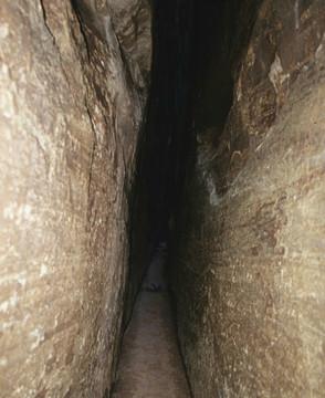
The narrow passageway shown in Mystery Photo #45 is located somewhere in the National Park System. Can you pinpoint this location? To get full credit for this one you need to state the name of the passageway and identify the national park in which it is located.
Readers who answer correctly will be eligible for our monthly prize drawing.
The answer will be posted in tomorrow's Traveler.
No cheating! If we catch you Googling or engaged in sneakery of any description, we'll make you write on the whiteboard 100 times:
Lake Chaubunagungamaug, a 1,442-acre lake near the southern Massachusetts town of Webster, bears an inordinately long name (perhaps the longest place name in the United States) that is often translated as "you fish on your side, I fish on my side, and nobody fishes in the middle." However, its approximate meaning in Nipmuc (an Algonquian language) is closer to "fishing place at the boundaries -- neutral meeting grounds." This water body is also called Webster Lake, especially by people who don't know how to pronounce Chaubunagungamaug.


Comments
This is a tough one. I'll guess the Devil's Hall Trail in Guadalupe Mountain NP, although I don't remember it being that narrow.
Sorry; it's not the Devil's Hall Trail in Guadalupe Mountain National Park.
Ellen Hardy has nailed it; a true bullseye. That's two. Anybody else?
Devils Den, Gettsyburg NMP
It's not Devils Den in Gettsyburg NMP. This photo wasn't taken in an eastern park.
Is it in Mammoth Cave?
How about the Subway in Zion?