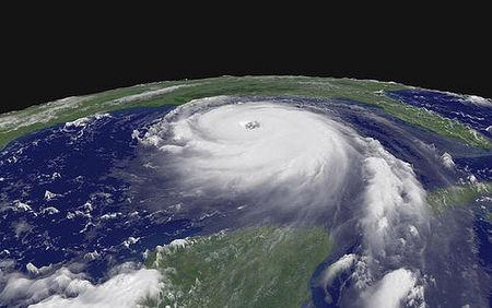
Officials at Padre Island National Seashore and at Palo Alto Battlefield National Historic Site have made careful plans to cope with Hurricane Dolly, which is expected to make landfall near Brownsville early Wednesday afternoon. Damage is expected to be minimal, but park officials are watching developments with a wary eye.
For National Hurricane Center information, maps, and updates pertaining to Hurricane Dolly, see this site.
Hurricane warnings have been posted as far north as Corpus Christi, meaning that the entire national seashore is expected to feel some effects of the storm. Palo Alto Battlefield National Historic Site is located in Brownsville, which is the vicinity of Dolly’s expected landfall. For map orientation, see this site.
People all up and down the Texas coast know that hurricanes coming out of the Gulf are potentially very dangerous and must be given a healthy degree of respect.
Gulf hurricanes can pop up quickly (or if arriving from the Atlantic, intensify rapidly) and then move onshore with startling swiftness. Since the coastal waters are shallow and the land is nearly flat, a storm surge – the really deadly part of the hurricane -- can be very dramatic.
Given these facts, Gulf Coast residents in the most hazardous areas go about their stormproofing with an extra measure of attention. One thing you’ll notice is that, when an unusually strong hurricane approaches, they habitually evacuate a lot sooner and faster than folks in similar situations on the Atlantic Coast.
Hurricane history has taught some stern lessons on the Texas Gulf Coast. The hardest of all was the Galveston Hurricane of 1900. Back then, hurricanes weren’t even named, forecasting was a relatively primitive business, and people living on the Texas coastal barriers didn’t know how fearsomely exposed they were. The monster hurricane that devastated Galveston in 1900 killed a guesstimated 8,000 people (perhaps as many as 12,000) and is still by far the most lethal natural disaster ever to strike the United States.
Hurricane Dolly, thank goodness, is not in that league. This is not to say that it won’t stir things up and leave its mark. Though modestly scaled as Gulf hurricanes go, Dolly is tightly defined and slow moving. That adds up to hefty winds of relatively long duration, plus lots and lots of rain (more than a foot of it in some areas). Remember that this is on nearly flat terrain that doesn’t drain well.
Another hazard is tornadoes, which are readily formed in the unstable air accompanying the hurricane
The Park Service is an old hand at dealing with Gulf hurricanes. Alerted to Dolly’s threat to the extreme south Texas coast, the staff at Padre Island National Seashore and at the Palo Alto Battlefield National Historic Site began putting their hurricane plans into effect this past weekend.
The infrastructure at the parks is now as secured as it’s going to get. Employees have been evacuated and both parks have been completely closed. They will stay that way until at least Friday.
Officials don’t think there will be severe damage at the parks, but the Padre Island beaches are likely to see some significant shoreline erosion and overwash effects. This is normal. Coastal barriers naturally function as gigantic shock absorbers. Dolly will dissipate a good deal of energy moving sand around.
After the storm has passed, it will be time to assess the damage, fix the things that need fixing, and get the parks back up to speed. Incident management teams have already scheduled early Thursday morning meetings to assess the damage. The National Park Service’s Central Incident Management Team is on standby pending these assessments.


Add comment