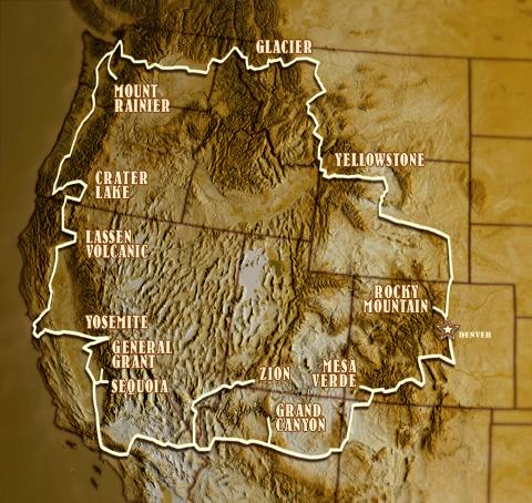
In the early 1900s, some national parks existed, but getting to them was problematic. Then was born the idea -- with the help of Stephen Mather, the first director of the National Park Service -- to develop a "National Park-to-Park Highway," one that would run through 11 states and connect 13 national parks.
It was a bold, even audacious, plan, as there were no paved roads, no gas stations, no mechanics. Those who were first to navigate it had no one to rely on but themselves, and so they had to be sure they hauled plenty of tools, parts, and fuel.
The route was one huge loop, leading from Denver to Rocky Mountain National Park, through Wyoming to Yellowstone, north through Montana to Glacier National Park, then west to Mount Rainier, south to Crater Lake, Lassen Volcanic, Yosemite, General Grant and Sequoia national parks, then east to Zion, Grand Canyon, Petrified Forest, Mesa Verde, and back to Denver. Definitely not a weekend road trip.
While you can now travel paved highways to all these parks, and no doubt make better time than those early road warriors did, getting a glimpse of the development of the National Park-to-Park Highway is not easily accomplished without a time machine.
Fortunately, someone made a documentary about it. That would be director Brandon Wade who, with a strong, but small, supporting cast created Paving the Way, the National Park-to-Park Highway.
On the clear, cloudless morning of August 26th, 1920, in the city of Denver, Colorado, twelve American motorists set out on a 5,000 mile, 76-day pilgrimage to all twelve National Parks. This Park-to-Park Highway was the longest motor route to date—and its roads were not even paved.
PAVING THE WAY: The National Park-to-Park Highway begins with a brief history of the automobile, from its status as a rich man’s toy to its remarkable affordability with the invention of Henry Ford’s assembly line. Once the average American is able to travel, civic movements such as “See America First” begin to promote tourism within the National Parks, shifting from the railroad to the automobile. The decimation of World War I and the flu pandemic of 1918 hindered this movement, but by 1920, the American public was ready to get out and explore the West.
However, roads for automobiles were crude at best. There were no reliable maps, gas stations, or convenience stores. Accommodations were few, far between, and expensive. Because of this, the newly established National Park Service decided to promote both tourism to the National Parks and the good roads to get there with the National Park-to-Park Highway.
Two characters played major roles in organizing the inaugural tour of this highway. Stephen Mather, the director of the National Park Service, was the major advocate for the highway linking the National Parks. However, Anton Westgard, a pathfinder for AAA, was the one who mapped the route through the parks and led the motorists on the tour. One provided the idea, the other provided the manpower.
You can learn more about the production, and buy a copy, from this website. In the meantime, here's the trailer:
PAVING THE WAY: The National Park-to-Park Highway - HD Trailer from Brandon Wade on Vimeo.


Comments
The Anton Westgard profiled in the film actually has a pass named for him in California's White-Inyo Mountains--Westgard Pass, appropriately enough.
That Westgard Pass region is in fact a world-famous place to examine "Cambrian Explosion" critters some 520 million years old in the rocks. Geologists and paleontologists from all over the world visit Westgard Pass and its immediate environs to study many fossil remains of extinct creatures over a half billion years old.
I have a web page up and running about the Westgard Pass paleontology, as a matter of fact: "Early Cambrian Fossils At Westgard Pass, California" over at http://inyo2.coffeecup.com/westgard/westgardpass.html .
Yes this area is beautiful. Too bad that it will be changing for the worst when Trump and his buddies open it up for oil drilling and mining. Our kids/grandkids will have no idea how beautiful it used to be.
I just finished watching the show on PBS. With this show, I found out how my Dad was able to map out (with the help of AAA) a road triip our family took in 1949. I can remember camping out beside the huge sequoia tree we drove though, camping in Yellowstone, Glacier, Crater Lake, Yosemite, Zion, Bryce Canyon, Grand Canyon and on and on. Motels, when we stayed in a motel cost one or two dollars for a family of 5. My wife and I have made the same trip on our Harleys. You can see many more sights riding a motorcycle than driving a car. You cannot always pull off the road in a car. You do not get to enjoy the smell of the country in a car. I have many happy memories of road trips throughout the USA. A very beautiful land!!!
Hard to tell on the little map illustration with the article, but on Google Maps I just figured out that if you head northwest from Spokane instead of southwest, you can add North Cascades National Park, only adding about half an hour to the trip.
I was also wondering if there is a current Day map of the still existing roads
Watching the show right now and loving it. I'm 5 years from retirement and this looks like 3 months of my retirement accounted for. Maybe longer. I have visited many of these parks. But never had the time to stop for more than a few days at any of them.
planning on doing it on my motorcycle this July. Starting in Washington. Just can't decide to go Widdershins or not.
I would be FUN to see what road's this made Up. I have traveled threw most of the Parks on ROAD TRIP's.Except Calaforna.GREAT.In the West put on about 20,000 miles on Back road's. Great Photo's to. And the rest of the Nation to is Great.[Smokie's,Az,Utah,ect,ect.]