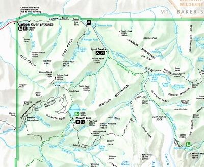
Out of the way for most travelers to Mount Rainier National Park, the Carbon River Entrance in the park's northwestern corner offers quick access to temperate rain forest, a nice hike to the snout of the Carbon Glacier, and a landscape frequently rearranged by the Carbon River.
It's that frequent, and costly, flooding that has park officials proposing to ban vehicles through that entrance and instead create a hiking and biking corridor. Indeed, the road has been closed to vehicles the past four years, since a vigorous storm pounded the park in November 2006.
An environmental assessment proposing the change in access currently is open for public review and comments. To help collect public comment, park officials have scheduled a trio of meetings -- on September 27, 29, and 30 -- to explain the EA and the options being considered for access to that part of the park.
The first meeting, on September 27, will be held at the City of Buckley Multi-Purpose Building, 811 Main Street, Buckley, Washington. The second meeting, on September 29, will be held at The Mountaineers Clubhouse in Tacoma, 2302 N. 30th Street, Tacoma. The third meeting, on September 30, will be held at the Seattle REI Store, Second Floor, South Conference Room, 222 Yale Avenue North, Seattle. All meetings will begin at 7:00 p.m.
During that November 2006 storm, record rainfall "triggered debris flows and major flooding in glacially fed tributaries, causing damage to all major access roads to Mount Rainier National Park," park officials said. "Flooding damaged and washed out several segments of the Carbon River Road, and altered the course of the Carbon River within the historic floodplain."
Of note, the road itself is listed on the National Register of Historic Places, according to park officials, who point out that the route "is an important part of the Mount Rainier National Historic Landmark District, and home to numerous threatened species and their critical habitat, including the northern spotted owl, the marbled murrelet, bull trout, Puget Sound Chinook salmon and Puget Sound steelhead trout."
Among the alternatives under consideration for the road are:
* Conversion of the road to a hiking and bicycling trail as called for by the park's general management plan;
* Reopening a portion of the road to public vehicles;
* Seasonal shuttle use of the road, and;
* Temporary use of the road as a hiking and bicycling trail while a wilderness reroute trail is constructed.
The "No Action alternative" calls for maintaining the route as an an unimproved hiking and bicycling trail. The park's preferred alternative and the environmentally preferred alternative is Alternative 2, conversion of the road corridor to an improved hiking and bicycling trail.
You can find the EA and its alternatives at this site (when it's working), where you also may comment on the proposal.
Comments should be postmarked or electronically date stamped no later than November 3, 2010.


Comments
The Carbon River area is about 45 minutes from my house, and one of my favorite places to go when I need to escape. I would love the road to be open all the way to Ipsut Creek again, but I know that's probably not possible (I've lived here for 17 years, and I think the road's been closed more often in that time due to flooding than it's been open).
It is absolutely gorgeous up there -- one of my favorite places on the planet.