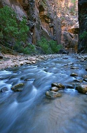
Due to the prospect of damage from winter floods, the 12 backcountry camp sites in the Narrows of Zion National Park are closed for the foreseeable future, according to park officials.
These campsites will remain closed until park rangers can safely enter the area, assess the damage, and perform any rehabilitation work that the sites may need, they added.
In late December, heavy rains caused extensive flooding on the North Fork of the Virgin River, including the Narrows. The flow rate for the river was measured at 6,000 cubic feet per second, the highest recorded rate since the campsites were created, a park release stated. Twelve designated backcountry campsites were created in the Narrows in the early 1990s in an effort to concentrate visitor impacts at specific locations and create a more enjoyable trip for visitors.
The Zion Narrows is closed to hikers each spring due to high water from snow melt. In an average year, the period of high water ends around the beginning of June. The closed campsites will be evaluated as soon as water levels allow rangers to visit the area. Many of the campsites should be opened quickly, but some may have to be re-located and may remain closed for several months, the park release said.
The National Park Service reminds visitors that all overnight trips in the Narrows require a backcountry permit. In an average year, reservations for overnight trips are available two to three months ahead of time through the park website at www.nps.gov/zion/planyourvisit/backcountry-reservations-and-permits.htm. In 2011, reservations will not be available until an evaluation of the campsites is complete.
The Narrows is a spectacular gorge carved in the upper reaches of Zion Canyon. It is 16 miles long, up to 2,000 feet deep, and at times only 20-30 feet wide. Hiking this route can be an unforgettable wilderness experience, but it should not be underestimated, park officials warn.
At least 60 percent of the hike is spent wading, walking, and sometimes swimming in the North Fork of the Virgin River. There is no maintained trail; the route is the river. The current is swift, the water is cold, and the rocks underfoot are slippery. Flash flooding and hypothermia are constant dangers. Good planning, proper equipment, and sound judgment are essential for a safe and successful trip.


Add comment