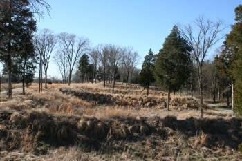
One hundred forty-nine years ago, in late December 1862, Union forces under General William Rosecrans advanced to attack General Braxton Bragg’s Confederates at their winter quarters near Nashville, Tennessee. Stones River National Battlefield commemorates the resulting vicious battle -- one of the bloodiest of the entire war -- fought at Murfreesboro on December 31, 1862 and January 1, 1863. The battle was a draw, but Bragg withdrew first and the Union claimed victory. Bragging rights aside, the Union came out of this battle with a morale boost, control of Middle Tennessee, and a vital forward supply base.
Here are some relevant statistics.
$1,299,000
The park's fiscal year 2010 operating budget.
187,559
Recreational visits to the park in 2010. Although visitation has held fairly steady in recent years, it remains far short of its 1993 peak of 283,283 and has not topped 200,000 since 2006.
23,517
Soldiers killed. wounded, or captured in the Battle of Stones River. Two earlier battles -- Shiloh (April 1862) and Antietam (September 1862) -- are more famously bloody, but neither produced as many killed (3,024) and wounded (15,747). The nearly 30% casualty rate suffered by the approximately 81,000 troops at the Battle of Stones River (called the Battle of Murfreesboro in the South) was unmatched in any major battle of the Civil War.
6,100+
Union soldiers buried in the park's 20-acre cemetery, which has 2,562 unidentified graves (some containing more than one set of remains). Confederate dead were interred elsewhere, with many consigned to mass graves.
709
Acreage of the park, all but 71 acres of which is federally owned. The park preserves key areas of the battlefield, which encompassed an area of more than six square miles (about 4,000 acres).
200+
Acreage of Fortress Rosecrans, a huge earthworks constructed after the Battle of Stones River. Named for Union commander General William Rosecrans, and sporting a perimeter of more than three miles, the massive fortification protected a segment of the Nashville Pike, railroad tracks, and a complex of warehouses, sawmills, and other facilities of a forward supply depot supporting the Federal campaign to capture Chattanooga, a key rail junction astride the invasion route to Atlanta.
nearly 7
Miles of hiking and walking trails in the park, including the moderately challenging 3.5-mile Boundary Trail that leads through wooded and rocky areas of the battlefield. The park's paved Cotton Field Trail, which passes through Hell's Half Acre (where some of the fiercest fighting took place), connects to Murfreesboro's Stones River Greenway and thus offers access to an additional 4.5 miles of paved trails along the Stones River and Lytle Creek.
2.2 miles
Length of the park's tour road. Though this road is designed for vehicular traffic, many visitors enjoy walking along it and stopping to take in the wayside exhibits.
1
Monument erected by William Hazen's brigade at Hell's Half Acre (aka Round Forest) in May 1863, just four months after the battle. The Hazen Brigade Monument, which is situated just outside the Stones River Battlefield National Cemetery, was sturdily constructed of limestone blocks and is arguably the oldest intact Civil War monument still standing in its original location.
0
Public access to the park's cedar glades, which is banned per the Superintendent's Compendium. Cedar glades are certain shallow-soil open areas containing a complex of plant species unique to Middle Tennessee. The endangered Tennessee coneflower and Pyne’s ground plum are among the dozen or so specially adapted plant species in this easily-damaged habitat.


Comments
Any information on soldier SHAW or John Moffitt is appreciated. Thanks........RLMourheat