The body of an unidentified man has been recovered from the approach to Longs Peak in Rocky Mountain National Park, where rangers found themselves working another search-and-rescue in the mountains leading into the night Friday.
The body was spotted early Friday morning below The Ledges by another climber heading up the Keyhole Route on Longs Peak. Rangers reached the body at 10:15 a.m. and confirmed the individual was deceased.
The U.S Forest Service Northern Colorado helicopter assisted with recovery efforts. The climber's body was flown to the helipad at Upper Beaver Meadows in Rocky Mountain National Park and was transferred to the Boulder County Coroner's Office. The name, age, and hometown of the deceased male was to be released after identification has been made and next of kin notified.
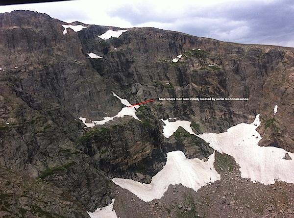
Later Friday afternoon, rangers were contacted via cell phone by a 31-year-old man, "who indicated he had fallen an unknown distance while glissading down Gabletop Mountain, which is above Loomis Lake in Rocky Mountain National Park. He reported numerous injuries," park spokeswoman Kyle Patterson reported. "The U.S. Forest Service Northern Colorado helicopter used earlier for the body recovery from Longs Peak was utilized for aerial reconnaissance. Using cell phone GPS coordinates, rangers were able to determine his general location below Gabletop Mountain and aerial surveillance confirmed his exact location."
Throughout the evening Friday rangers periodically stayed in contact with the climber via cell phone.
"The man is located in a remote high alpine environment in a steep cirque above Loomis Lake approximately 11,300 feet," Ms. Patterson said in a release. "Loomis Lake is southwest of Spruce Lake. Tonight, before night fall, a team of four park rangers were flown to Loomis Lake. Equipment was also flown into the general area. These flights occurred in between severe thunderstorms. The man began to descend steep snow slopes toward Loomis Lake, which is helping rangers have a better chance of reaching and assisting him tonight."
This locator map shows were the unidentified climber was stuck above Loomis Lake on Friday afternoon/NPS


Add comment