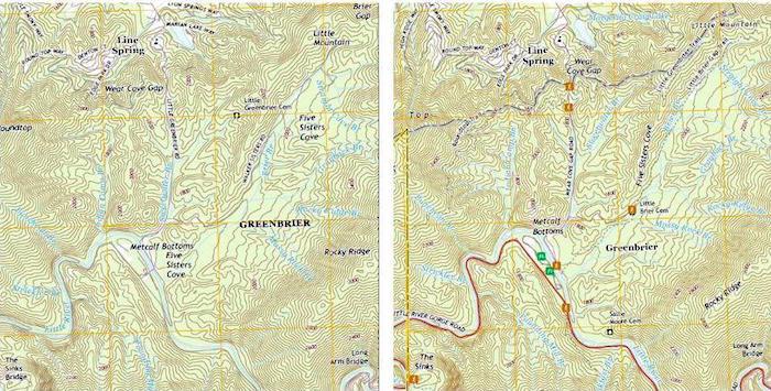
New 2016 US Topo quadrangle within Great Smoky Mountains National Park showing the addition of six trailhead symbols, two picnic areas, several and trail systems and the Little River Gorge Road compared to the same 2013 US Topo quad. (1:24,000 scale)/USGS
Newly released US Topo maps for Great Smoky Mountains National Park provide more detail on the park, displaying the locations of trails, campgrounds, visitor centers, boundaries and other visitor information in the national park.
“Across the country, visitors to national parks will benefit from these new features on maps, but it’s especially fitting that the nation’s most visited national park - the Great Smoky Mountains National Park - is the inaugural park for the joint pilot project between the USGS and the NPS," said Kari Craun, director of the USGS National Geospatial Technical Operations Center. “We look forward to continuing our work with the Park Service by adding this important and useful data to US Topo products nationwide.”
“As we celebrate our 100th anniversary, our program focuses on connecting new generations to parks with digital map technology,” said Julie Recker, Enterprise Geographic Information Systems manager for the National Park Service. “The NPS plans to share data from its central GIS data warehouse to the USGS National Map and Topo products, as part of the NPS Centennial Call to Action ‘Going Digital.”’
Great Smoky Mountains National Park was established in 1934. It straddles North Carolina and Tennessee and covers more than 816 square miles. With more than 10 million visitors per year, the park is known for its scenic vistas, lush forests, abundance of wildflowers, and miles of hiking trails, including a segment of the Appalachian National Scenic Trail.
The addition of the Appalachian Trail segments is an ongoing project for the USGS to eventually include all National Scenic Trails in The National Map products. The segment collection includes parts of the Ice Age National Scenic Trail, the Pacific Northwest National Scenic Trail, the North Country National Scenic Trail, the Pacific Crest National Scenic Trail, the Arizona National Scenic Trail, the Natchez Trace National Scenic Trail, the New England National Scenic Trail, and the Continental Divide National Scenic Trail. The addition of the NPS trails information to US Topo products is expected to provide additional value to recreational hikers venturing beyond the National Scenic Trails.
Other improvements to the new US Topo quadrangles are the inclusion of the U.S. Census Bureau’s Topologically Integrated Geographic Encoding and Referencing (TIGER) road data, the integration of wetlands layers using data from the U.S. Fish & Wildlife Service National Wetlands Inventory, along with the continued incorporation of high-resolution streams and rivers from the National Hydrography Dataset.
“The nationwide similarity in the look and feel of the maps, as well as a very widespread understanding of how to use them, make USGS topographic maps the best mapping tool for park employees, emergency personnel, and visitors,” said Great Smoky Mountains Superintendent Cassius Cash. “It is my hope that we can replicate this relationship with all 411 units across the country.”
The US Topo map improvement program is nearing the end of its third, three-year cycle of revising and updating digital US Topo quadrangles. These new US Topo maps replace the second edition US Topo maps and are available for no-cost file download from The National Map Download client and several other USGS applications.
To compare change over time, scans of legacy USGS topo maps, some dating back to the late 1800s, can be downloaded from the USGS Historical Topographic Map Collection.


Comments
If you zoom in very closely, perhaps you can see where they diverted Ace Gap trail away from former Gov. Don Sundquist's home and gave him land from within the park. Then move on over where Blair gap comes in and you can see the private trail system blazed by famous Blackberry Farms and a clear cut of about one thousand trees for the exclusive use of their $600 per night clients that often include Saudi Sheiks.
Yes, the wheels of commerce are very alive in the Smokies, for the connected few.