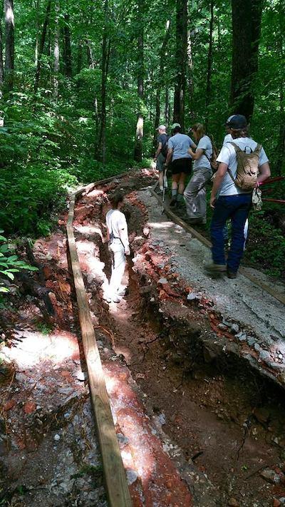
Trail damage near Lost Valley in Buffalo National River/NPS
The National Park Service will close the Lost Valley Road and day-use area at Buffalo National River in Arkansas on Monday for a 10-week-long improvement project that will relocate a portion of Lost Valley Road, parking area, and trailhead out of the immediate flood zone of Clark Creek. The purpose of this project is to provide safe vehicular access to the Lost Valley Trailhead while minimizing adverse impacts to Clark Creek, the Buffalo River, and the surrounding environment.
Lost Valley is a point of interest located at the western end of Buffalo National River near the town of Ponca. It is one of the most popular destinations at Buffalo National River, receiving approximately 77,000 visitors per year. The Lost Valley area features a heavily used hiking trail, picnic area, amphitheater, pavilion, and restrooms.
The improvement of the Lost Valley area in order to better serve visitors has been an ongoing process. A section of the Lost Valley Trail was upgraded in 2012 to make it barrier-free to comply with standards set by the Architectural Barriers Act. The upgraded section did not include the first 720 feet of the trail (measured from Clark Creek).
An environmental assessment for additional improvements to the Lost Valley Trail was completed in 2013. Under this project, a new pedestrian bridge over Clark Creek would be installed and the first 720 feet of the trail from the new bridge would be realigned and upgraded to make it barrier-free. Also included in the EA was the permanent closure of the campground at Lost Valley and upgrading the amphitheater to make it barrier-free. The new bridge over Clark Creek has not yet been constructed.
Storm events frequently result in flash flooding and the discharge of vehicle contaminants, silt, sand, gravel and clay roadway material directly into adjacent Clark Creek, where it is transported a short distance downstream to the Buffalo River. The rapidly fluctuating water levels of Clark Creek present serious challenges to the maintenance of the road and the safety of visitors. During the spring and summer, frequent heavy rain and flooding overwhelms drainage areas, causing widespread issues with the road and ditch lines. Damage to the road and parking area makes the trail and facilities inaccessible to visitors during flood events and difficult to access afterwards until repairs can be made.
Recurring flood damage to the trail, road, and parking area since its initial construction has led the NPS to propose moving the facilities from their current location to minimize future damage.
The planned improvements will have a beneficial impact on water quality and species of special concern due to the reduction in the sedimentation of Clark Creek and restoration of riparian area. The improvements will also have a beneficial impact on visitor use and experience by providing more sustainable access and parking. The Architectural Barriers Act-accessible portion of the existing Lost Valley Trail will also be repaired, which will drastically improve accessibility for visitors with limited mobility. The pedestrian bridge across Clark Creek will be constructed in the near future as part of a second project phase.
Lost Valley is expected to reopen in late February 2019. Nearby alternatives for day hiking include the Buffalo River Trail, Beaver Jim Villines Homestead Loop, Hideout Hollow Trail, and Mill Creek Trail. See this page for detailed maps and descriptions of these alternatives.


Add comment