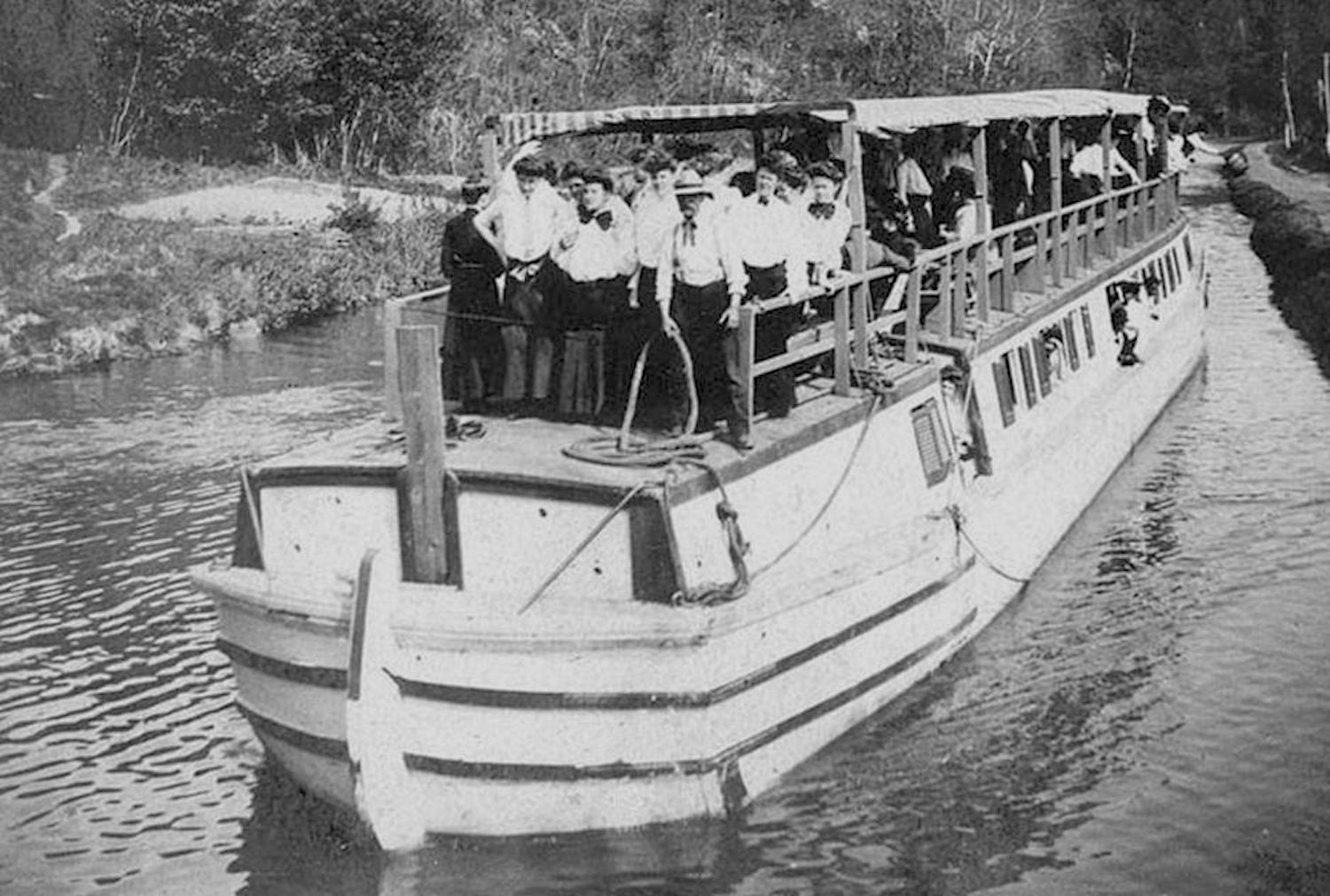
A packet boat on the Chesapeake and Ohio Canal/NPS archives
Editor's note: The following is the first part of a two-part series examining the Chesapeake and Ohio Canal National Historical Park. It's written by Joel Cohen, a visiting scholar at the Nicholas School for Environmental Science at Duke University.
A Remarkable Journey
Walking the canal towpath towards Georgetown, one comes across a sign that is literally almost in the Potomac River, reading in urgent letters, “Deadly undertow, Get to shore.” But this undertow is only one of the Potomac’s lethal actions; it is also capable of serious flooding causing immense damage. In fact, it was a series of such floods that propelled the Chesapeake and Ohio Canal to change course, from its historic role of commercial transport to one of becoming a conduit for wildlife, and entering the National Park System as a National Historical Park.
These floods came in three different eras of the canal, but cumulatively, were severe enough to contribute to a change in canal’s history and status. The first of these was in 1889, causing damage so great that it led to the canal’s economic failure and canal management was forced into receivership with the Baltimore and Ohio Railroad. The flood of 1924 was severe enough to close the canal permanently, with the final straw coming in 1942, erasing all of the restorative work that the Civilian Conservation Corps had accomplished.
That series of events ended the commercial life of the canal. Today, it stands as a place of exploration and recreation, and that is what visitors find when they come to the park through one of its many entrances.
But just how exactly did the Chesapeake and Ohio Canal come to be in the first place? To answer this, go back to July 4, 1828, when, after years of planning and deliberations, President John Quincy Adams finally broke ground at Little Falls, Maryland, and construction officially began. It was some 22 years later, not the three years originally predicted, that the first group of five canal boats, loaded with approximately 120 tons of coal, raced downstream from Cumberland, Maryland, towards Georgetown in the District of Columbia. It was Abe Saunders, Captain of the Freedom Rendon, who successfully locked-through all of the locks to reach the tidewater of the Potomac River that lay at the city’s edge, marking the canal’s Eastern-most point.
Some seven days prior, Saunders had started his boat from Cumberland, on the evening of October 17, traversing the 184.5 miles, with he and his canallers edging out the Southampton at the last moment. The year was 1850, and the opening of the canal between the West and East had begun, finally fulfilling the original purpose as set by the C and O Canal Company, that being to link up the Eastern Seaboard states with the agriculture and industry of the Ohio Valley.
For the canal to succeed as a business venture, it required some true feats of engineering ingenuity from the chief engineer, Mr. Benjamin Wright. Though taking far longer than expected, many of Wright’s ingenious solutions that solved almost intractable problems in crossing the rough and uneven terrain that lay in front of it still remain. When done, boats were able to travel on water with cargo up to 135 tons by passing through the 75 locks, either gaining or dropping in altitude of 600 feet, crossing over 11 aqueducts, traversing a 3,113-foot tunnel through solid rock, working six hour shifts while watching over two sets of mules, family, and children.
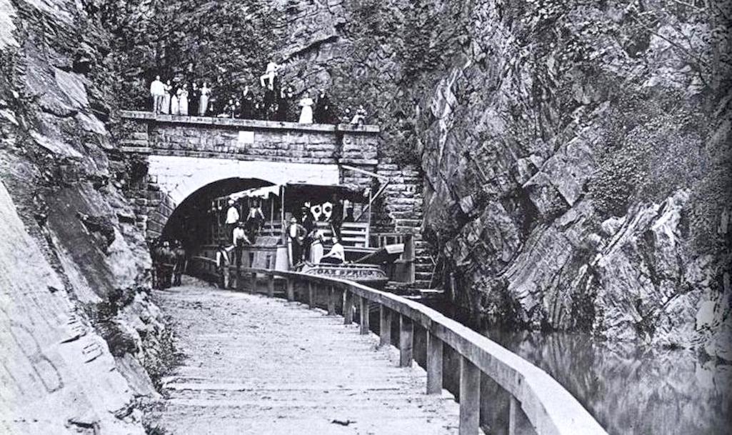
Canal boats had to pass through the Paw Paw Tunnel/NPS Archives
For 74 years, operations on the full length of the canal continued, with crews made up mostly of men until the last years of operation, when families frequently operated the boats, living and working on the narrow waters next to the Potomac River. Some children also grew up on the canal boats, and houses were built for lock keeper families, with small centers of commerce springing up where none had been before. Then, this way of life came to an end, and by the time the canal was procured by the U.S. government, it was a very neglected and rundown version of its previous self. The year was 1938, leaving the government with a suddenly-owned, non-functional canal, and no clear vision as to what would be its future.
Becoming A National Historical Park
Today, some 170 years after it opened, the once plentiful canal boats are gone, but what remains is something Mr. Benjamin Wright would not have foreseen. For each of the canal’s 184 miles is integrated in distance and greenery from one end to the other, helping it become a “conservation corridor.” What was once a major thoroughfare for travel and trade has become two parks in one.
If Mr. Wright were alive today, he would see that most of its locks and lock keepers’ homes are still intact, some even refurbished, and many locks still operational, plus 11 aqueducts are present, including the 560-foot Monocacy Aqueduct, which still amazes those who see it. The towpath, originally built for the mule team, has been renewed and now supports bikers and hikers of all kinds. This remarkably preserved history combines intuitively, as if knowing where in the natural history of the terrain it belongs, and perhaps this is one reason that the park provides a contiguous, yet strikingly diverse wildlife habitat.
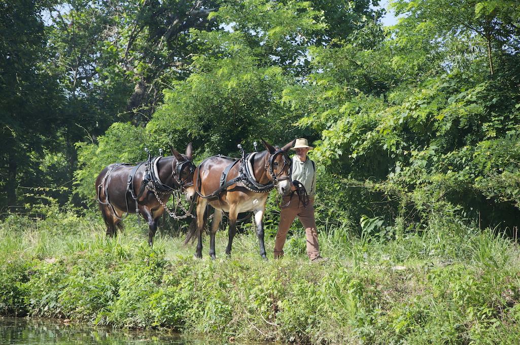
Mules historically pulled the canal boats still used today to pull the canal boat located at Great Falls Tavern Visitor Center/NPS
It is hard to imagine now, but in the early 1950s, not long after the canal came to the U.S. Government, the canal’s unique historical and natural diversity was almost disrupted by building a parkway through it, as advocated by editors of the Washington Post. The parkway would be for automobiles, and to speed either vacationers or employees into the Capital. But, as it turns out, this idea was not to stand, as a single individual made a counter-proposal in 1954. It single-handedly changed the course of the debate.
This suggestion came from U.S. Supreme Court Justice William O. Douglas, who invited all those willing to join him on the towpath to hike the canal and see for themselves its special beauty and natural history. Members of the Post accepted the justice’s invitation, and upon their return the journalists no longer favored a highway of any type. Instead, they wished to see the canal become a park, with all of the existing land preserved. After long and protracted negotiations, the highway idea was put aside, and the park preserved as it is today.
Following this decision, President Eisenhower signed a proclamation establishing the transformation of the commercial canal in Maryland into the C&O Canal National Monument. While affording recognition of the canal’s new status, it stopped short of outright rejecting the possibility for road development in the future.
However, as it turns out, this would not be the final edict for the canal. For, in 1971, the status of the park came before the Office of the President when Richard Nixon was serving. He signed the final act, creating the C&O Canal National Historical Park. By his signature, the newly created agreement increased the total acreage of the park from 5,000 to 20,000 acres. At last, what once carried commerce and canal boats was transformed to a true national historical park with a focus differing entirely from that of the past, but which kept the past close to its heart.
With President Nixon’s signature, the C&O Canal National Historical Park came under the watchful eye of the National Park Service, which opened its doors in 1916 following the signing into law of the Yellowstone National Park Protection Act in 1872 by President Ulysses S. Grant. Presently, the lands forming the National Park System cover 84.6 million acres, where in places such as the C&O Canal National Historical Park visitors can experience not only the extent and diversity of natural history, but also important acts of American history, seen either within or outside the park’s perimeter.
The Park's Partners
With the inception of the C&O Canal National Historical Park, partner organizations have come forward, each attracted to particular features or needs. These organizations work closely with, and augment the funding and care provided by the National Park Service.
Some of these partnerships include the Potomac Appalachian Trail Club, the Canal Trust, C&O Canal Association, the Maryland Native Plant Society, The Potomac Conservancy, and Georgetown Heritage. Through their services, the entire length of canal, adjoining riverbed, towpath, buildings, trails, benches and even canal boats are upgraded and maintained.
This spring, in a project hosted by Georgetown Heritage and the National Park Service, a brand new canal boat, manufactured and built at Roudebush Yacht and Engine Works, will make its first appearance, ready to travel through the renovated and renewed Georgetown lock system.
The acts of nature that were the first engine of change where the canal now stands go back in geologic time and were capable of twisting and turning all that lay upon the earth, and as it happened, the rivers formed and glaciers came and went, forming the likes of Mather Gorge, as Great Falls became Great, the Potomac river which twisted and turned so much that a great tunnel encompassing the canal and tow path was carved out of the Appalachian Mountains, and the rise up to Georgetown from the murky tidewaters of tidal basin. While these beginning geologic transformations, occurring over millions of years, are very old, the idea of nature reserves that now contain these formations is a very new one.
Yellowstone was the first such park in the world. It has been noted, that because, “nature reserves are among the youngest, nations still don’t understand all the things such reserves can do, or how to use them properly and fully.” Such are the challenges to come when considering the future of the C&O Canal National Historical Park.
Joel I. Cohen is currently a Visiting Scholar, at the Nicholson School for the Environment, Duke University, where he is working with Dr. Stuart Pimm on the C and O Canal Park and its potential to serve as a wildlife “conservation corridor.
Traveler footnote: To learn more about the canal's lock houses, read Kim O'Connell's piece on Canal Quarters.


Add comment