Editor's note: Yellowstone Caldera Chronicles is a weekly column written by scientists and collaborators of the Yellowstone Volcano Observatory. This week's contribution is from Shaul Hurwitz, research hydrologist with the U.S. Geological Survey.
Volcano observatories operate in many countries and are responsible for monitoring and communicating the hazards posed by active volcanism. Several organizations help with the transfer of knowledge between scientists and the emergency managers who are responsible for preparedness, response, and mitigation.
To understand why scientists need to better understand volcanic hazards, we can learn from Marie Curie, the first woman to be awarded a Nobel Prize, and the first person to receive the award twice, in physics (1903) and chemistry (1911). Curie stated that, “Nothing in life is to be feared, it is only to be understood. Now is the time to understand more, so that we may fear less.” In other words, the more we know, the less we should fear.
It is the responsibility of the USGS Volcano Hazards Program to deliver forecasts, warnings, and information based on scientific understanding of volcanic processes so that eventually, we may fear less. Volcano monitoring, eruption response, and hazards assessment at U.S. volcanoes fall under the mandate of five regional volcano observatories that cover more than 160 active volcanoes. The first volcano observatory established in the USA was the Hawaiian Volcano Observatory, which was founded at the summit of Kīlauea volcano in 1912, and the most recent is the Yellowstone Volcano Observatory, which was established in 2001. The first volcano observatory in the world was organized in 1841 on the slopes of Mount Vesuvius in Italy (Vesuvius Observatory or, in Italian, Osservatorio Vesuviano).

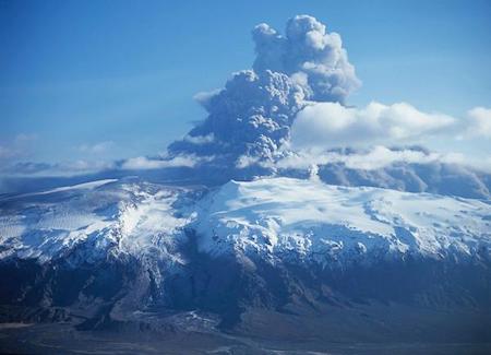
Photograph of the 2010 eruption from the summit of Eyjafjallajökull from the north looking to the south across the Gígjökull outlet glacier, its "missing" proglacial (ice-margin) lake caused by the jökulhlaup that filled in the lake/Oddur Sigurðsson, Iceland Meteorological Office, April 17, 2010.
Although each volcano observatory around the world operates under the jurisdiction of a single country, there is a need for cooperation to study and monitor volcanoes across national boundaries. This is because the hazards from volcanic eruptions can cross borders, and the impacts of very large eruptions can be global.
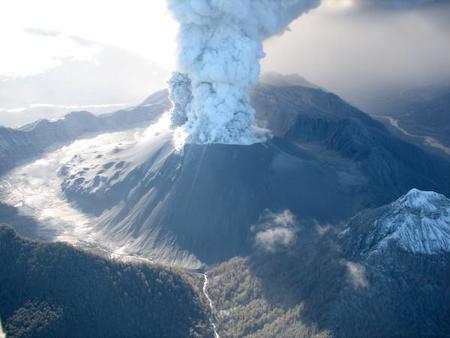
Examples of the global reach of volcanic eruptions include the ash cloud from the 2010 eruption of Eyjafjallajökull in Iceland that disrupted air traffic in Western Europe for several weeks. Similarly, the 2008–2009 rhyolitic eruption of Chaitén Volcano in Chile dispersed over more than 200,000 km2 (about 77,000 square miles) in Chile, Argentina, Uruguay, and the South Atlantic Ocean, disrupting commercial airline traffic and daily life in many downwind communities.
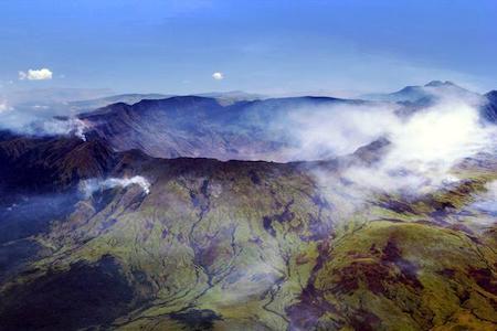
The 1815 Tambora eruption on the island of Sumbawa, in Indonesia, was one of the most powerful eruptions in recorded human history, with a volcanic explosivity index (VEI) of 7. Ash from the eruption column dispersed around the world and lowered global temperatures in an event known as the year without a summer in 1816. The 1783–1784 Laki eruption in Iceland was responsible for the deaths of 60 percent of the island’s livestock and 20 percent of the human population within a year. The eruption also caused significant health problems for millions across Europe and led to one of the coldest winters on record in North America.
The responsibilities of volcano observatories can often seem overwhelming. They need to monitor for signs of hazardous eruptions (large and small) and get that information to the public in a timely manner. At the same time, observatories need to ensure that the best technologies and knowledge are used to aid in these missions. Fortunately, there are several organizations tasked with aiding volcano observatories in working together and getting out their important messages. These organizations range from international scientific societies to government-sponsored organizations.

View of Chaitén lava dome looking north, on May 26, 2008. Note simultaneous explosion and effusion of new lava on left-central side of dome. Caldera is about 3 km wide/USGS, Jeff Marso on May 25, 2008.
The International Association of Volcanology and Chemistry of the Earth’s Interior (IAVCEI) is the major professional association of volcanologists. IAVCEI operates several disciplinary commissions, including the World Organization of Volcano Observatories (WOVO) that aims to encourage communication and cooperation between observatories and institutions directly involved in volcano monitoring. IAVCEI also organizes a scientific assembly every four years to provide an opportunity for scientists to exchange knowledge and learn from experiences gained in other countries. To address the importance of communicating volcanic hazards information to the public, IAVCEI sponsors biannual conferences (the “Cities on Volcanoes” series) that bring together volcanologists, city and county managers and planners, sociologists, psychologists, and economists to evaluate volcanic crisis preparedness, mitigation, and management in populated areas.
A worldwide network of nine Volcanic Ash Advisory Centers (VAAC) was set up by the United Nations to coordinate and disseminate information on atmospheric volcanic ash that may endanger aviation around the world, like the aforementioned eruptions from Eyjafjallajökull and Chaitén. Each VAAC focuses on a particular geographical region and is run as part of national weather forecasting organization of the country where it is based (there are two in the US). The VAACs provide ash advisories based on expert analysis of satellite observations, ground and pilot observations, and interpretation of ash dispersion models.

Aerial view of the caldera of Mt. Tambora, island of Sumbawa, Indonesia/Jialiang Gao, Wikimedia Commons.
The USGS Volcano Disaster Assistance Program (VDAP), co-funded by the USGS and the U.S. Agency for International Development’s Office of U.S. Foreign Disaster Assistance (USAID/OFDA), works with international collaborators on adding newly developed monitoring technologies, training and exchange programs, and eruption forecasting methods to greatly expand global capabilities that mitigate the impacts of volcanic hazards.
The Global Volcanism Program (GVP), part of the Smithsonian Institution, documents and disseminates information about global volcanic activity. The GVP maintains a catalog of volcanoes and eruptions from the past 12,000 years and, in collaboration with the USGS, issues a weekly volcanic activity report. On the GVP website, you can check the status of current volcanic eruptions around the world (be warned, though: it’s a very fun website, and it’s easy to spend a lot of hours reading about different volcanoes!).
To return to Marie Curie’s wisdom, over the past several decades, significant progress has been made “to understand more” the myriad global hazards posed by volcanoes. Additional research, monitoring, and international collaborations will help being better prepared and protected from these hazards “so that we may fear less”.


