A northerly view along the Yakima River in the Umtanum Ridge Water Gap National Natural Landmark / Rebecca Latson
When is something associated with the National Park Service (NPS), yet not a unit within the National Park System? When it’s a National Natural Landmark (NNL).
I wrote a 2022 article for the Traveler about unit designations within the National Park System and mentioned my inability to locate NNLs within these designations, even though I noticed they appeared connected somehow with the NPS. Soon after, I heard from reader Laurette Lee Jenkins, NPS NNL Coordinator for the Pacific West Region, who clarified for me the role of the NPS regarding NNLs. “NNL designations are honorific and not regulatory -- a site is designated an NNL [by the NPS] as an outstanding example of a natural feature” encompassing anywhere from four to 900,000 acres.
The NNL program is administered by the NPS, and these natural landmarks “are located anywhere, including within city, state, county parks, wildlife refuges, national forests, tribal lands, nature preserves, ‘backyards’ of private individuals, and other federally- and privately-owned lands.” As of 2021 there are 602 NNLs within 48 states. Click that link to discover NNLs near you.
There are 18 NNLs in Washington state, where I live. Throughout this year, I’m planning short road trips to find, photograph, and learn about as many of these natural features as I can reach. Thus far, I’ve visited only a handful of the 18 NNLs, but I’ve learned some interesting things via these trips, discussions with Ms. Jenkins, and this link to an NPS site with a lengthy list of NNL FAQs. Since what I’ve learned applies to any NNL and not just a Pacific Northwest one, I thought I’d share while describing the few NNLs I’ve visited which might be of interest to you too, if you happen to be traveling through my neck of the woods.
Just because an NNL is NPS-designated, and the NPS administers the NNL Program, that doesn’t mean the selected landscape will eventually become a National Park System unit under regulatory control and thus open to the public. They aren’t really tourist destinations and policies applying to National Park System units “do not transfer to NNLs.”
Thirty percent of NNLs are completely privately-owned and 18 percent “are owned or administered by a mixture of public agencies and private owners.” Can you visit those privately-owned NNLs? Probably no to some, but maybe yes to others, if you ask nicely. If you’ve done the math, 52 percent of NNLs are administered by public agencies in addition to that 18 percent owned or administered by a combination of public / private entities. So, while it might be challenging to access some NNLs, the majority of these places are open to the public.
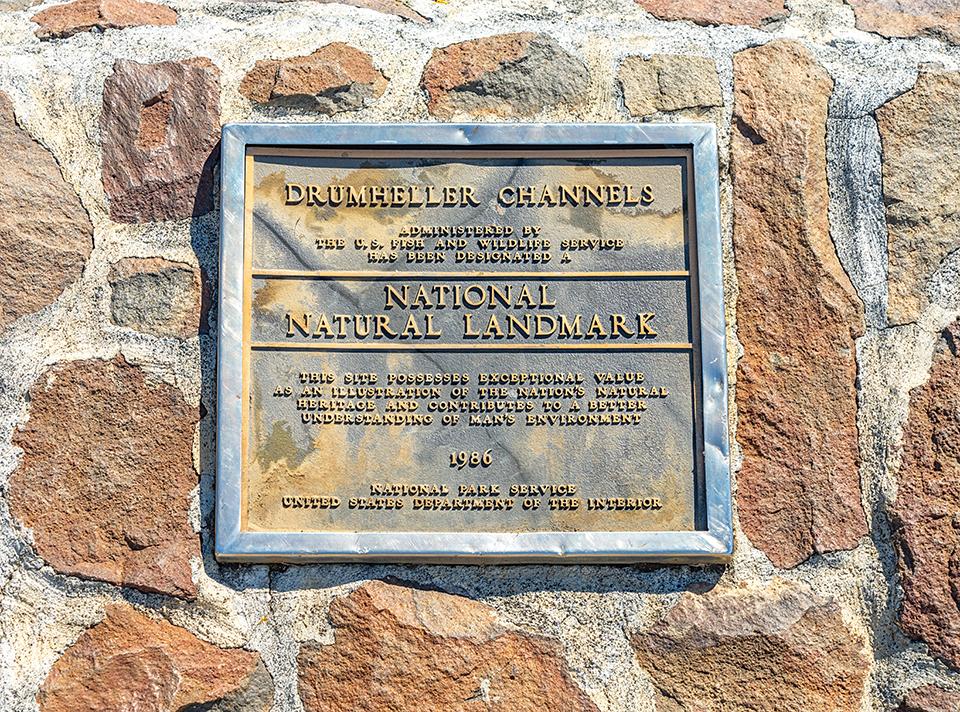
Drumheller Channels National Natural Landmark marker plaque / Rebecca Latson
If you wish to travel to a specific NNL, do your homework first, and secondly never assume anything. For example, I made the mistake of assuming I’d easily find my way to any NNL on my list via a roadside marker similar to the plaque affixed to a rock wall marking the Drumheller Channels NNL overlook. According to Ms. Jenkins, “plaques are usually provided when a landmark is designated - but not always. NOT all NNLs are good candidates for the bronze plaques i.e., private landmarks don't usually receive a bronze plaque but may receive some other type of recognition. Also, some NNLs are simply too remote to justify [a] bronze plaque and those that have been placed at remote sites are often stolen. New guidance to NNL land manager is to think about plaque security (i.e., behind a gate that gets locked a night). Landowners and managers are responsible for plaque installation.” This all means there is the possibility of you getting downright lost trying to figure out an NNL location.
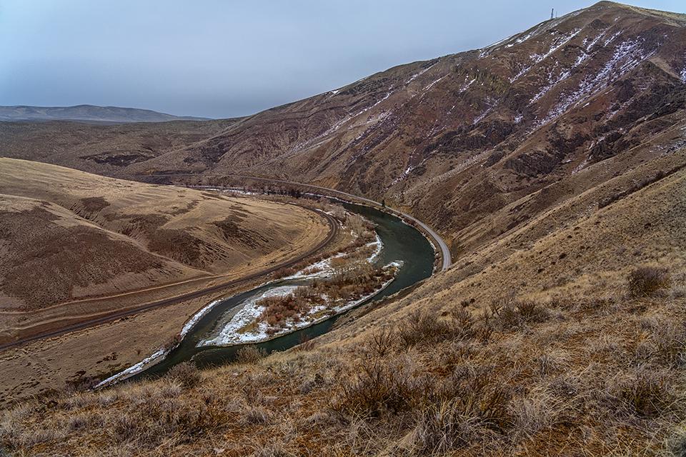
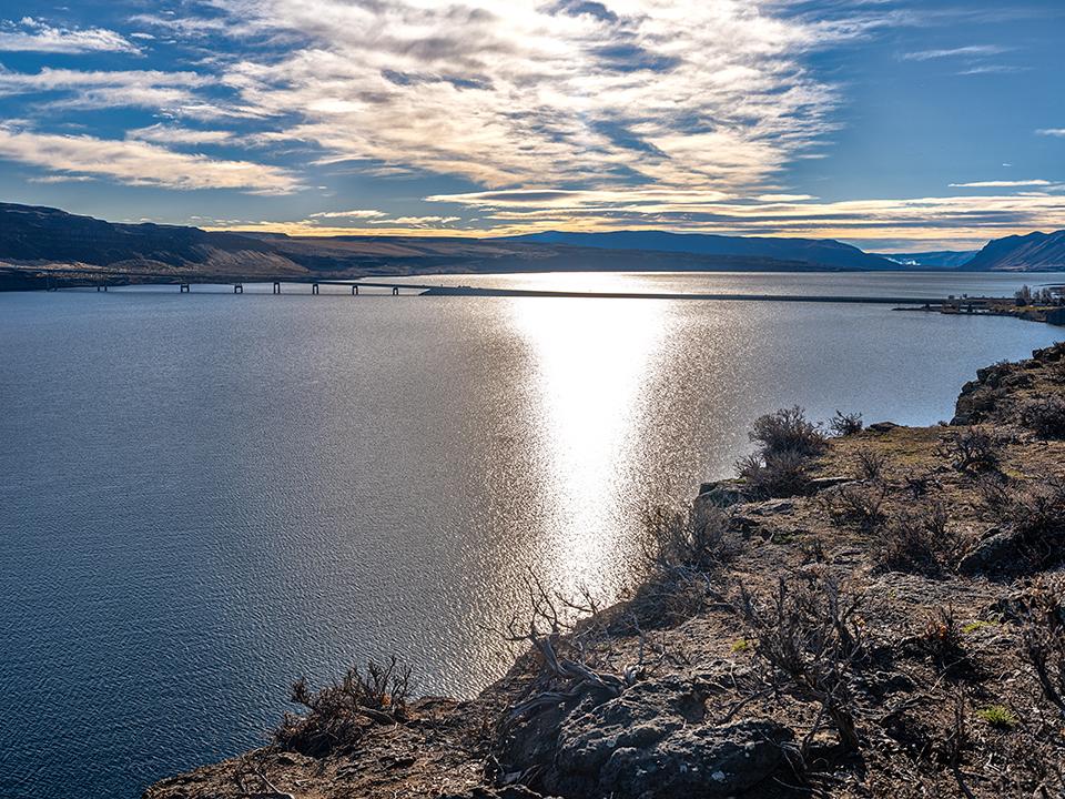
Case in point, I drove the entire length of the Yakima Canyon Road (WA State Route 821) from Yakima to Ellensburg while attempting to pinpoint the Umtanum Ridge Water Gap NNL. Finding no signs or other markers, I blithely assumed the entire route of the Yakima River flowing through the Yakima River Canyon incorporated the Umtanum Ridge Water Gap NNL, so anywhere I photographed would be within that NNL. I continued that assumption because I couldn’t really find any sort of boundary-marked map on Google. Later review of a boundary-delineated topo map subsequently provided by Ms. Jenkins resulted in the realization all my photos composed during that morning’s road trip were completely outside the NNL boundary lines.
The Yakima River flowing through Umtanum Ridge Water Gap National Natural Landmark / Rebecca Latson
FYI a water gap is a pass in a mountain ridge cut by a stream or river. The Umtanum Ridge Water Gap was created by the Yakima River cutting downward through the Umtanum Ridge anticline (a series of upfolded rock layers). The Umtanum Ridge Water Gap NNL was so designated because the Yakima River is considered “one of the best and most convincing examples of an antecedent river in the United States.” An antecedent river is one that maintains its course during its downward erosion, never veering its path despite the continued movement of some landform – in this case, the Umtanum Ridge anticline uplift.
If you find yourself driving Interstate 90 between Seattle and Spokane, you should stop for a visit (and maybe even a nice stretch of the legs), at Ginkgo Petrified Forest NNL, a state park of 7,124-acres considered “the single most diverse locality of Miocene petrified wood in North America.” Petrified wood is Washington’s official state gem, as a matter of fact.

A view of the Columbia River and petrified logs at Ginkgo Petrified Forest State Park / Rebecca Latson
Situated along the Columbia River just outside of Vantage, WA, Ginkgo Petrified Forest State Park / Wanapum Recreation Area hosts an interpretive center, boat ramp, campground, day-use facilities, and three miles of nicely-maintained hiking trails over windy, barren, beautifully lonely landscape allowing the hiker to “weave through petrified logs in their original setting …” with the caveat that some of the smaller petrified logs are caged in situ to prevent vandals from absconding back to their vehicles with a “souvenir.”
The wild, beautiful landscape of Ginkgo Petrified Forest National Natural Landmark / Rebecca Latson
Try to get past that, though, and enjoy the scenery while learning about the myriad petrified tree species (sycamore, Douglas fir, maple, elm, spruce, ginkgo) dotting the volcanic rolling hills. During your hike, you might encounter elk, bighorn sheep, or the northern pacific rattlesnake, and for those of you interested in Civilian Conservation Corps architecture, take note of the trailside museum / caretaker’s residence constructed in the 1930s and marking the start of this state park’s trail system. A signage-walled alcove explains the natural processes behind the landscape and the possible reason for so many different tree species discovered so closely together.
The CCC-built trailside museum and caretaker's residence, Ginkgo Petrified Forest National Natural Landmark / Rebecca Latson
Even though NNLs are not units within the National Park System, they may be located within units that actually are within the National Park System. Mentioned (directly or roundabout) in the first and third articles I wrote for the Traveler about the NPS’ Ice Age Floods National Geologic Trail are a couple of NNL landscapes located within the embrace of the Channeled Scablands: Grand Coulee NNL and Drumheller Channels NNL.
Stretching from Grand Coulee Dam down to Dry Falls and then on to Soap Lake, 50-mile long Grand Coulee is not only the largest coulee in the Columbia Plateau, but is also considered the finest example of a recessional cataract gorge.
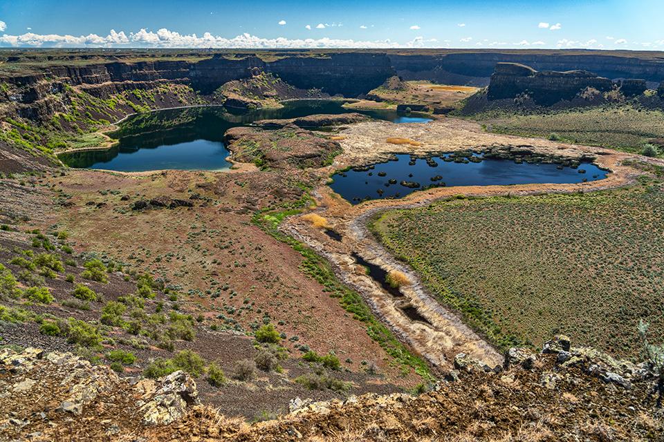
Dry Falls, a part of Grand Coulee National Natural Landmark along the Ice Age Floods National Geologic Trail / Rebecca Latson
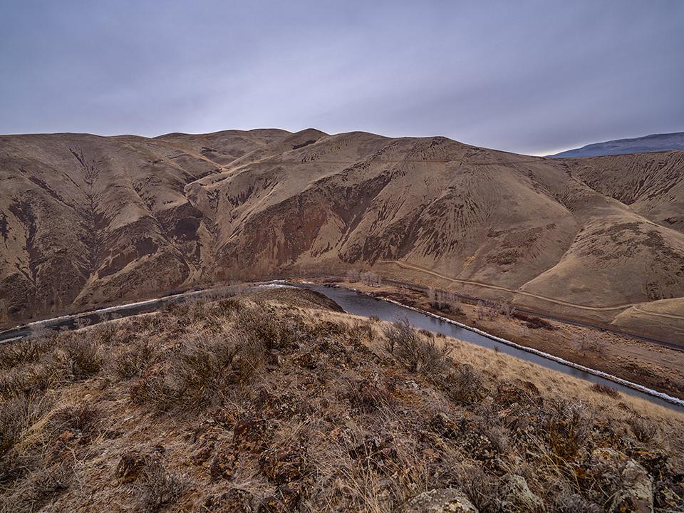
Drumheller Channels just outside of Othello is deemed the best example of basalt “butte-and-basin” channeled scablands.
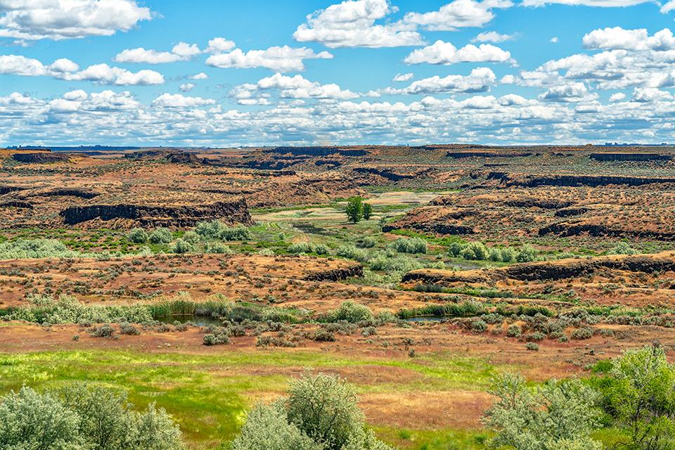
The butte-and-basin landscape seen from the Drumheller Channels National Natural Landmark view area / Rebecca Latson
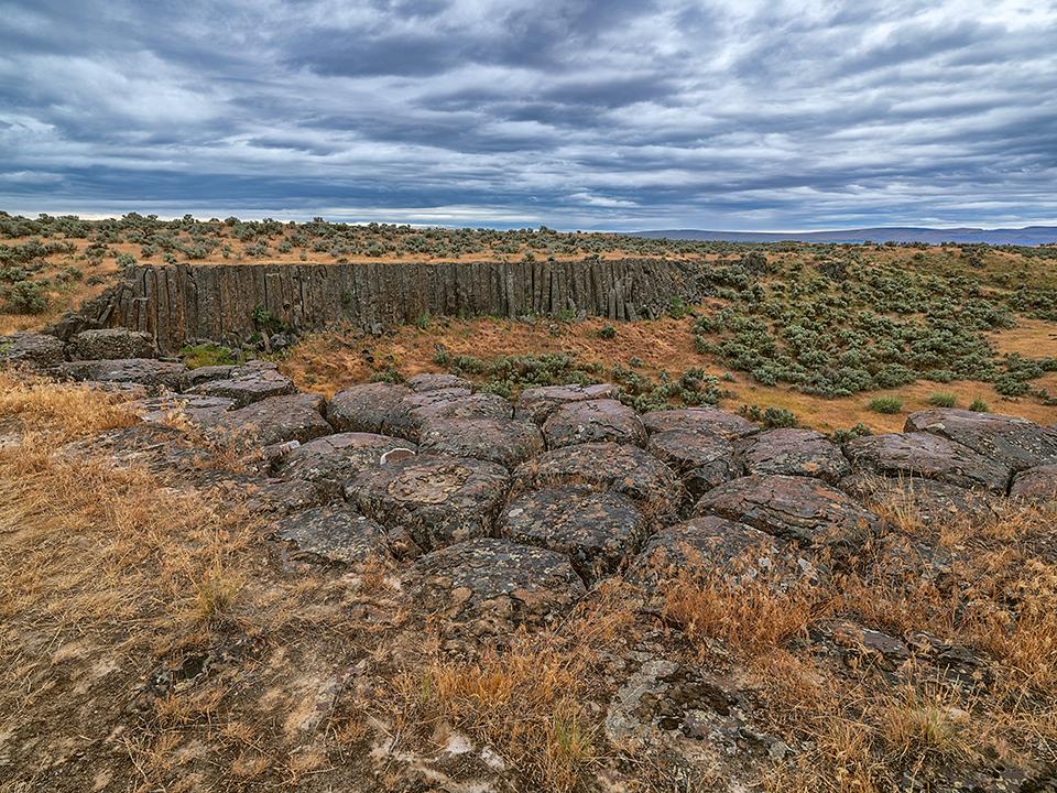
Columnar basalts of butte-and-basin Drumheller Channels National Natural Landmark along the Ice Age Floods National Geologic Trail / Rebecca Latson
Both NNLs are great examples of different administrations (federal, state, and private) working together to manage and protect these NPS-designated landscapes.
Preservation of any environment, but especially of these amazing features, is always a concern. As mentioned earlier, NNLs are not under the regulatory auspices of the NPS but rather voluntary commitments on the part of the landowner/manager. It’s not mandatory for the site owner to care for or protect the NNL, although it behooves them to do so for the distinctive honor an NNL bestows. Of course, the NPS visits these NNLs to monitor their condition and, if necessary, remove the NNL designation, but the onus is on the landowner/manager to maintain and protect the site with its special characteristics. If you visit an NNL, you can do your part in protecting the site by picking up any litter you see, and packing out what you pack in.
While not National Park System units, you should still definitely drop in on at least one or two of these special places, particularly if you don’t have the time to visit a National Park but still need a little break from the home or office routine. NNLs are great for a day or half-day trip to recharge those mental batteries, provide a little “nature balm” for the eyes and soul, and teach you about their noteworthy environments. NNLs are not national parks, but they are NPS-designated sites chosen because they provide some of the best examples of a biological or geologic feature. Surely that’s worth a looksee, right?
A near-noon vista of the Columbia River from Ginkgo Petrified Forest State Park / Rebecca Latson

