
The beginning of sunrise at Dantes View, Death Valley National Park / Rebecca Latson
There’s a t-shirt in the general store at Furnace Creek with the words “Land of Extremes” emblazoned over a screenprint of Badwater Basin, a cow skull, and a bright sun shining in the background. Death Valley National Park is, indeed, a land of extremes: extreme heat, extreme rainstorms, extreme dryness, extreme beauty. If you are planning on visiting this national park, you definitely need to be prepared.
The Traveler penned a checklist for Death Valley back in 2012. I just returned from a six-day visit to this national park, so think of this 2023 checklist as an addendum with photos. My advice: read both checklists.
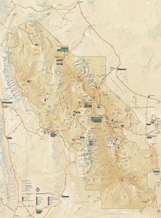
The official NPS map of Death Valley National Park / NPS file
The park is open year-round, but winter through early spring is really the best time to visit, not only for less haze and clearer views of the valley landscape, but also for cooler temperatures. That said, you go when you have the time and budget to go, and if that time is May - September (considered summer in the park), then by all means go. Not all facilities may be open at that time and you’ll need to prime yourself for extreme heat ranging anywhere from 100 degrees F (37 degrees C) to 130 degrees F (46 degrees C).
What should you pack? That depends upon the time of year you travel. During the summer, include sunscreen, hat, maybe a long-sleeved t-shirt or two, shorts or lightweight pants, and sturdy shoes or boots in your luggage. I did see people wearing Teva-type sandals and sneakers, too. Oh, and bring your swimsuit!
In the winter, take along a jacket and warm hat, since temperatures – particularly in the higher elevations - may not get above 40 degrees F (4 degrees C). It will always be warmer in the valley, no matter what time of year, but those temperatures will still be considerably cooler than during the summer season.
You’ll either be driving or flying (then driving) to get to Death Valley. From Las Vegas’ Harry Reid International Airport to the east, it’s a smidgeon over two hours’ drive. Btw, you may know that airport as McCarran International Airport, but a name change was approved during the latter part of 2021. Probably the next-closest commercial airport is LAX in Los Angeles, and it will take you over four hours’ drive to enter the park’s west side. There are other smaller airports around the park, but good luck getting a flight there or finding an available rental car.
Make your lodging reservations early – at least three months early if not earlier. Even in the high heat of summer, room obtainability dwindles quickly.
Speaking of lodging, there are several brick-and-mortar options to serve as basecamp for your Death Valley adventures: Furnace Creek, Stovepipe Wells, Panamint Springs. Furnace Creeks offers the upscale Inn at Death Valley as well as the more budget-and-family-friendly Ranch at Death Valley. For information and reservations at either, click here.
I stayed six nights in a second-floor hotel-type unit at the Ranch at Death Valley, 190 feet (approx. 58 meters) below sea level. Furnace Creek is a self-contained “community” of one- and two-story hotel rooms, cottages, a general store, gas station, golf course, bar (excuse me – saloon), ice cream parlor, buffet-style restaurant, upscale retail/western gift shop, outfitter (closed for the summer), bar and grill (closed for the summer), golf pro shop, swimming pool, tennis court, basketball court, and museum (currently closed), all next door to the Furnace Creek Visitor Center (the one with the famous thermometer). Each hotel-style room comes equipped with coffee maker (single servings), fridge, television (with surprisingly good reception), AC, and WiFi (reception worked well on my laptop and not so well on my cell phone).

A second-floor hotel-style room at the Ranch at Death Valley, Death Valley National Park / Rebecca Latson
The Inn at Death Valley looks out from colorful, sun-dried hills over neatly-spaced date palms and blooming shrubs with views toward the valley. In addition to the rooms within the main building, there are also new casitas thanks to a multi-million-dollar restoration project. If it’s ambience you want where the likes of Bette Davis, Clark Gable, and James Cagney stayed back in the day, then this is the place to go … if rooms are available there.

Date palms, flowering shrubs, and movie star ambience at the Inn at Death Valley, Death Valley National Park / Rebecca Latson
Located between Furnace Creek and Panamint Springs, Stovepipe Wells sits right next door to the Mesquite Flat Sand Dunes. This very small community located about 10 feet (~3 meters) above sea level hosts a general store and gas station, hotel, restaurant, and saloon. There is a ranger station next door, open “depending on temperature and staffing.” For information and to make a reservation at the Stovepipe Wells Village Hotel, click here.
Panamint Springs Resort near the park’s western border is rustic and small, located across the road from the campground and next door to the restaurant, gas station, and general store. Panamint Springs is only a few miles away from Father Crowley Vista Point and Rainbow Canyon (aka “Star Wars Canyon”), where military test flights zooming through the canyon wowed photographers and onlookers until a fatality curtailed fighter jet runs.
Death Valley hosts several campgrounds but not all of them are open due to the extreme summer temperatures. Click here to learn more about the developed, primitive, and private campgrounds, how to reserve a campsite, and how to manage any pets you bring along to those sites. Bring your own firewood or purchase some at the general stores since all vegetation in the park is protected.

The Furnace Creek Campground is one of several campgrounds within Death Valley National Park / Rebecca Latson
Bring water. Lots of it. Seriously. Gallon jugs of water. Much more than you think you’ll need. It’s surprising just how much water you’ll drink during your stay in this very dry, very hot national park. Oh, and bring along salty snacks to replace salts lost through sweat. You can either stop at a grocery store along your way to the park, or purchase water and snacks at any of the general stores within the park.
Bring a little more cash than you think you need. Why? Infrastructure in this park is basically in the middle of nowhere, which means the cost of transporting food and other supplies will be higher. In turn, this cost is passed down to you at the cash register. Gasoline also costs more. During my stay, I paid $6 per gallon at the Furnace Creek station, and $4.99 per gallon at the Stovepipe Wells station. The Panamint Springs station ranges between those two prices on any given day.
Be aware cell service may be spotty. I brought along my small Garmin satellite communicator, which was probably overkill since I did no backcountry hiking/camping. After suffering a flat tire in Big Bend National Park some years ago, however, I now pack a tire pressure gauge as well as my Garmin if for no other reason than peace of mind.
What can you do while visiting Death Valley National Park? Plenty! Start with those iconic locations about which you’ve read so many times. Welcome the sunrise at Zabriskie Point as the sun bathes the Panamint Mountains across the valley then broadens its reach to include the terra cotta-shaded hillsides around the view area.

The beginning of sunrise at Zabriskie Point, Death Valley National Park / Rebecca Latson
From there, drive back toward the Inn at Death Valley and turn left onto Badwater Road to Badwater Basin (lowest point in North America at 282 feet below sea level). Once you’ve parked your car, walk the flat, 1.5- to 2-mile (2.4 – 3.2 km) packed salt ground out to the larger, more pristine polygonal salt pan. Wear sunglasses because the bright white of those salt polygons will hurt your eyes on a sunny day. Try to finish hiking before 11 a.m. during the summer. The reflected sunlight from the salt flat adds to the heat factor.

Wear sunglasses when you stand on a bright salt pan at Badwater Basin, Death Valley National Park / Rebecca Latson
On the way back to CA-190 (the main road through the park), take the side road up Artists Drive to Artists Palette and marvel at the eye-popping “palette” of colors created by minerals such as iron oxide and chlorite. There are no trails there but plenty of pullouts for you to stretch your legs while making a closer examination of those colorful soils.

The colorful soils of Artists Palette, Death Valley National Park / Rebecca Latson
After that full morning, why not go take a dip in the Ranch’s swimming pool, followed by lunch at the Last Kind Words Saloon or enjoy a fresh sandwich, salad, or vegetable or chicken wrap purchased from the Ranch’s general store.

The Wild West character of the Last Kind Words Saloon at the Ranch at Death Valley, Death Valley National Park / Rebecca Latson
Afterwards, take a nap or, if you feel like a leisurely golf game, play a round at the Furnace Creek Golf Course, 214 feet (65.23 meters) below sea level. To cap off the day, return to Zabriskie Point and watch the sun sink behind the Panamint Range. Stay a little longer for stargazing at this spot.
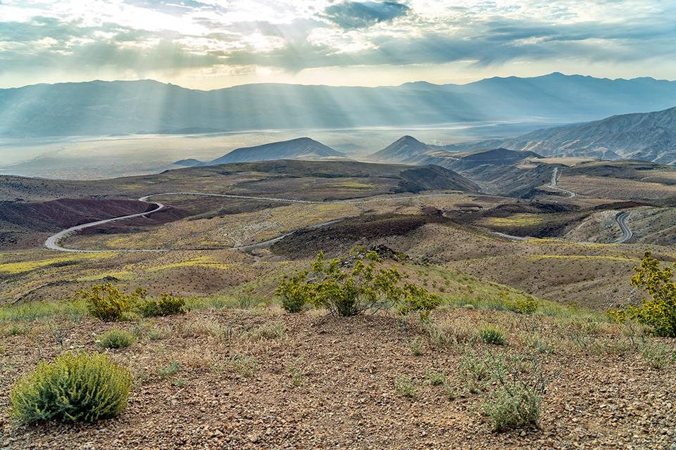
Next morning, get up early (as in dark-thirty) and drive to Dantes View at an elevation of 5,575 ft (1,699 m) above Badwater Basin to welcome the sunrise. You might find yourself returning for sunset and sticking around for a little star gazing, too. Death Valley National Park is an International Dark Sky Park and I can tell you from personal experience it’s well worth the wait to view diamond-sparkly stars set against an inky night sky.

The end of sunset and beginning of night at Dantes View, Death Valley National Park / Rebecca Latson
In between sunrise and sunset appointments, drive to Stovepipe Wells (if you are not already lodging there), stopping along the way to take a short self-guided tour of the Harmony Borax Works before continuing your drive to scale the sand dunes.

The golden curves of the Mesquite Flat Sand Dunes near Stovepipe Wells, Death Valley National Park / Rebecca Latson
Warm morning or evening sunlight over the dunes creates a richness of depth and shadows perfect for photography. Include a human or two you might see in the distance to indicate the size and scale of these dunes.
Another view area with an incredible vista is the Father Crowley Vista Point, mentioned earlier. Note: the paved view area with the vault toilets is next to Rainbow Canyon. To see the panoramic view of Panamint Valley, Panamint Mountain Range and surrounding landscape, you’ll need to walk or drive the ¼-mile gravel road just off the parking lot.
The landscape panorama you can view at Father Crowley Vista Point, Death Valley National Park / Rebecca Latson
This national park offers hikes suitable for every level, from flat and easy Badwater Basin (below sea level) to Telescope Peak (elevation gain 3000 ft. / 914 m). Just remember to play it safe and limit your activities to the morning and late-afternoon / evening hours. Not only will the temps be “cooler” (all things being relative out there), but the lighting will be perfect for great photo ops. The only way to escape that moisture-sucking, furnace-hot heat is to drive to someplace like Dante’s View or Father Crowley Vista Point, or someplace at or above 3,000 feet (914 meters) above sea level, where the temperature cools down by five degrees F (three degrees C) for every 1,000 feet in elevation.
“Know before you go.” Do your homework and explore the National Park System’s website for Death Valley for a list of alerts and closures in addition to what you can and cannot do while visiting. Don’t assume everything will be open when you arrive or that you can do anything you want in the park. This is especially true after a natural event like the flooding that closed the park in August 2022.
I encountered two young men openly using their drone (the whine of a drone is hard to miss). Perhaps they feigned innocence for my benefit, or perhaps they were indeed as surprised as they looked when I told them drones were not allowed in the park and they could be fined up to $5,000 and spend six months in jail, if caught. I also encountered two other young men who had been openly digging holes into the packed salt of the Badwater Basin trail near the parking lot, looking for salt crystals which they could photograph. Digging holes or doing any other type of damage to natural features within Death Valley is a no-no. It takes the landscape a very, very long time to recover, if at all.
Be prepared for weather changes, like incoming thunderstorms. Flash flooding carrying debris onto the road can occur in a matter of minutes. While photographing at Badwater Basin one evening, I watched huge, beautiful, dark storm clouds slowly drift toward me with a curtain of rain already descending upon the Furnace Creek area in the distance. My first thought was to protect myself from lightning strikes on the exposed salt flat. Hotfooting it back to my rental truck, I thought I’d make it back to my room before the rain began, only to end up driving through blinding rain, with sheets of water and rock/dirt debris gusting across the road from one waterlogged side to the other. The next day, Badwater Road (including the side roads to Artists Drive, Devils Golf Course, Golden Canyon, Natural Bridge, and Ashford Mill) was closed due to flooding and debris.
Bringing a pet? Don’t forget, the ground gets awfully hot for unprotected paws and your four-legged pals get just as thirsty as you out in that heat. Click here for dos and don’ts about pets and where you can take them in the park.
Death Valley National Park is an experience not to be missed and should be on your national park bucket list. Do your research, plan ahead, and plan smart to enjoy this hottest, driest, lowest “land of extremes” within the National Park System.

Just how hot *can* it get in May at Death Valley National Park? / Rebecca Latson

