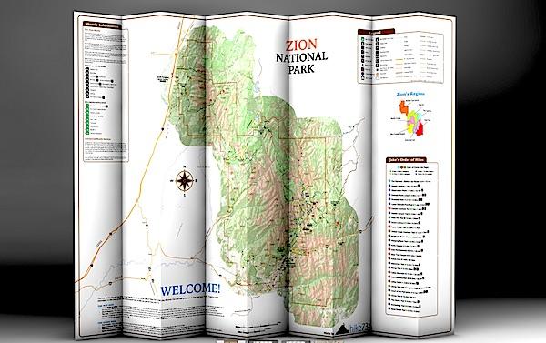
Day Hikes Of Zion National Park folds into a nice, waterproof, portable guide to Zion's day hikes/hike734
You're planning a trip to Zion National Park in Utah, you plan to do some hiking, and you're wondering which trails to search out.
You could pick up a copy of 50 Best Short Hikes In Utah's National Parks, which would be a good start in identifying some hikes in Zion. But a new "map guide" from Jake Bramante, the guy who hiked all 734 miles of Glacier National Park in one year, would be a good investment, too, if you're solely interested in day hiking in the park.
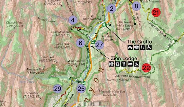
Day Hikes of Zion National Park, which provides details on 29 hikes in the park, is printed on tear-resistant, waterproof paper that folds down to a roughly 4.5-inch by 9-inch brochure that you can stuff in your back pocket or day pack. Unfold it and you find a map of the park with key facilities (restrooms, visitor center, lodging, picnic areas, etc) marked along with numbered hikes. Shuttle bus stops in the park as well as neighboring Springdale also are numbered to help you catch a ride.
This map is similar to Bramante's Day Hikes Of Glacier National Park. Hikes in the Zion guide are color-coded by region in the park. So if you look at all the purple-coded hikes, you'll know they're in the same general area of the park; in this case, in Zion Canyon. Green circles denote trails on the West Rim, violet is tagged to those on North Creek, yellow indicates southwest desert, light blue is The Narrows, and red is Kolob Canyons and the East Rim. Lines denoting the trails are even color coded: green for easy, yellow for moderate, and red for strenuous.
The map color codes hikes by region, and uses more colors to denote easy, moderate, and strenuous hikes/hike734
A glance at "Jake's Order of Hikes, which lists his favorites in descending order, tells you whether you'll encounter steep cliffs, whether a particular hike is family friendly, and whether the trail is accessible.
On the back of the map you'll find a breakdown of the trails with descriptions. Here Bramante segregated the hikes by distance, so you can quickly identify the mileage so you don't overdo it. You'll also find a box of safety information, ranging from steep cliffs in the park to the need to drink lots of water in this desert setting and even symptoms of heat stroke.
There's even a small box of information on where you can obtain additional books and maps.
If day hiking is your goal, this is a good tool to help you plan, and pull off, your day-long journeys in Zion. You can order a copy at Mr. Bramante's website.


Comments
I frequently get an overnight backcountry permit in Big Bend NP and they keep making the process easier and friendlier.
Actually, most parks coordinate GPS locations of park features, including backcountry camp sites, with in-house geographic information systems used to produce a variety of maps for purposes of resources management. These data are already in hand, but perhaps not released to the public via park web sites.
Personally, I do not see any downside, nor administrative difficulty, in making this information available as a public service. Perhaps it's only a matter of time and staff priorities.
Sorry Tomp2, I just now saw your posted information, which duplicates what I've said above.
In my experience the 'artist in residence' program is not a 'performing artist' [which puts me in mind of a singer or musician] but more often a painter or photographer. The product of such a program can benefit many.
"The Artist-In-Residence Program at Rocky Mountain National Park offers professional writers, composers, and visual and performing artists the opportunity to pursue their artistic discipline while being surrounded by the park's inspiring landscape"
http://www.nps.gov/romo/getinvolved/supportyourpark/artist_in_residence.htm
Apparently things vary. The announcement for the 2015 Chilkoot Trail Artist Residency program [a joint NPS/Parks Canada effort], which is local to me, mentioned visual artists.
Sorry, ec, if I seemed to push back too hard. Maybe getting the info posted online would take less time and effort than I realize, but I've seen too many cases of "quick and easy" projects that prove not to be as advertised. This is just one of many examples of competing priorities for employee's time, and if this is being worked on, then something else won't get done. As Owen says, it's a matter of setting priorities - and different people see what should be at the top of the list differently.
No doubt we all have different priorties. As my mom used to say, "thats why they don't make it all vanilla". And there is nothing wrong with that.
Do they have these maps available at a rngr station some where at the park enterance?