Ten trails in eight states have been added to the National Trails System/Ashley Decker
To mark National Trails Day on Saturday, ten trails with a combined 160 miles of path have been added to the National Trails System. The newly designated trails join a network of more than 1,300 existing national recreation trails, which can be found in every U.S. state.
“As COVID-19 vaccination rates increase and our nation takes a collective and cautious sigh of relief, we need recreational resources now more than ever to strengthen physical, social and mental health across our country,” Interior Secretary Deb Haaland said Friday in announcing the additions. “National recreation trails boost local economies, provide communities with safe, equitable access to the outdoors. This National Trails Day, I hope everyone finds time to enjoy the great outdoors.”
The national recreation trails program is jointly administered by the National Park Service and the U.S. Forest Service, in conjunction with multiple federal and nonprofit partners. The designation of a national recreation trail can be done by either the Secretary of the Interior or the Secretary of Agriculture on an existing local or regional trail with the consent of the federal, state, local, nonprofit, or private entity that has jurisdiction over the trail. The trail's managing agency or organization must apply for the distinction.
Today’s trail designations are consistent with the principles of the Biden-Harris America the Beautiful initiative, a decade-long campaign to support locally led conservation efforts across the country.
“Trails connect neighborhoods, literally and figuratively,” said National Park Service Deputy Director Shawn Benge. “These newly designated national recreation trails recognize the incredible efforts of local trail stewards and enthusiasts to provide the public with close to home outdoor access for strolling, pedaling or paddling.”
The National Trails System, which includes national scenic, national historic and national recreation trails, offers an abundance of opportunities to experience the majestic landscapes of the country and build awareness of historic events that have shaped the nation. A database of recreation trails across the United States is maintained through American Trails, a national, nonprofit organization working on behalf of all trail interests, including hiking, bicycling, mountain biking, horseback riding, water trails, snowshoeing, cross-country skiing, trail motorcycling, ATVs, snowmobiling, and four-wheeling.
“American Trails applauds this new slate of Secretarial designations from the Department of the Interior and is excited to continue to promote our country’s national recreation trails,” said Mike Passo, Executive Director, American Trails. “These trails connect the gems of our National Trails System to the places where Americans live, work, and play. The national recreation trail program uniquely highlights trails that are accessible, relatable, and serve a wide diversity of our nation's public.”
Secretary Haaland has designated the following as national recreation trails. Each will receive a certificate of designation, a set of trail markers, and a letter of recognition.
Alabama
Bethel Spring Recreational Preserve Trail System
Bethel Spring Nature Preserve is a 360-acre property on Keel Mountain with 200 acres open to the public for outdoor recreation. The preserve currently offers hikers 1.8 miles of free trails to explore from dawn to dusk daily, including upland forest, working farmland, historic sites, an environmentally significant spring and creek, as well as one of Madison County’s largest waterfalls.
Chapman Mountain Recreational Preserve Trail System
Chapman Mountain Nature Preserve is a 459-acre property located just to the east of Huntsville. With 3.28 miles of trails for visitors to explore, the preserve offers hiking, biking, and horseback riding trails, open from dawn to dusk daily. An 18-hole disc golf course offers another way to play outside and a large open-air pavilion at the trailhead provides space for gatherings.
Green Mountain Recreational Preserve Trail System
Green Mountain Nature Preserve offers 4.9 miles of trail varying from easy to difficult. The trail system offers the opportunity to explore natural features like streams and waterfalls, and interesting historic features.
Illinois
Farmdale Trail System
The Farmdale Trail System is a network of mountain biking trails located on the U.S. Army Corps of Engineers Farmdale Reservoir Area. The trails offer 16.3 miles of everything from wide, hardened dirt to twisting single track trails. The trail system allows users to experience the hills, valleys, creeks and standing timber of a time before agriculture transformed the area.
Kentucky
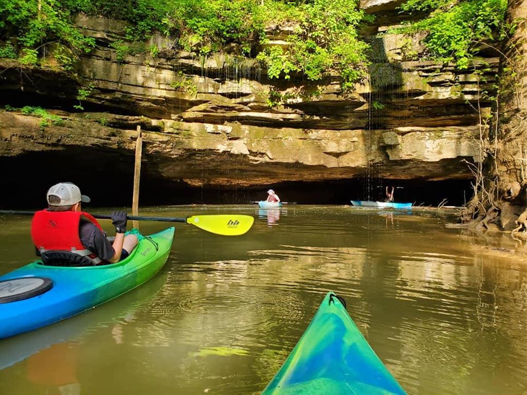
Green and Nolin Rivers Blueway
The Green and Nolin Rivers Blueway is located within Mammoth Cave National Park, with sections in the neighboring Edmonson County and the Nolin Lake Tailwater. The Blueway includes 36 miles of navigable waterway and seven public access sites. The Blueway offers paddlers the opportunity to explore the biological and geological wonders offered by the national park and surrounding area.
Missouri
Crabtree Cove Trail
Comprised of three separate loops, the Crabtree Cove Trail spans a total of 2.59 miles through U.S. Army Corps of Engineers Stockton Lake. While there are several trails offered around the dam area, the Crabtree Cove Trail is one of the most popular and is frequently used by the visiting public. This trail offers easy access to enjoy hikes, bird watching, picnics, and swimming.
North Carolina
Piney Knob Trail System
The Piney Knob Trail System consists of 13.5 miles of recreational hiking and mountain biking trails. All trails are dirt single-track trails and built in accordance with International Mountain Bicycling Association standards, which provide for an excellent recreation experience.
Texas
Apache Creek Greenway
The Apache Creek Greenway is part of the Westside Creeks Trails of the Howard W. Peak Greenway Trail System in San Antonio. It runs approximately four miles along Apache Creek and intersects with several city parks. The Apache Creek Greenway is an important part of San Antonio’s Westside community as it ties together neighborhoods that embody the city’s rich Mexican American history and Hispanic culture.
West Virginia
Greenbrier River Trail
The Greenbrier River Trail is a 78-mile former railroad now used for hiking, biking, and horseback riding. It is the longest trail of its kind in West Virginia. The trail provides many breathtaking views as it passes through several small towns, crosses 35 bridges, goes through two tunnels, and cuts through some of West Virginia’s most remote areas.
Wyoming
Fort Laramie National Historic Site’s Confluence Trail offers a pleasant 1.6-mile stroll along the shady banks of two waterways, the North Platte and the Laramie Rivers, as they near their confluence. The resulting riparian area has long offered shelter and valuable resources for people and wildlife. The riparian band of vegetation contains a wide range of plant and wildlife habitats, much as it has throughout history.


Comments
National Recreation Trails are such a peculiar designation as absolutely nothing about these trails changes other than a different sign to put up at the trailhead. No additional funding so NRT really doesn't make any difference.
The designation may change people's awareness of the place and inspire them to do the trail.
i missed Cahokia Mounds when I was in St. Louis many years ago because they didn't have then any eyecat hung designation. It can make a differenc.