1. True of false? Only one of the 392 National Park System units has the word “wind” as part of its official name.
2. True or false? The orientation of the dunes at Great Sand Dunes National Park and Preserve indicates that the prevailing wind in that part of Colorado is from the northwest.
3. True or false? In the stream valleys of Glacier National Park, summer afternoon breezes tend to blow in the same direction that the water flows.
4. True or false? At Cape Hatteras National Seashore in North Carolina’s Outer Banks region, the windiest month (highest average wind speed) is February.
5. True or false? Point Reyes National Seashore has the highest average annual windspeed of any National Park System unit on the Pacific Coast of the Lower 48.
6. True or false? At the natural entrance to the namesake cave of Wind Cave National Park, the wind blows into the cave some of the time and out of the cave some of the time.
7. True or false? If you want to go windsurfing in Acadia National Park, it's helpful to remember that windsurfing is allowed on lakes, but not on ponds.
8. True or false? If you want to see whether you can talk a National Park Service law enforcement ranger into issuing a warning instead of a summons, a good way to do it is to let the ranger see you driving your ORV on the wind-sculpted dunes of Oregon Dunes National Recreation Area.
9. True or false? National park visitors on Hawaii’s Big Island tend to find the mildest, most comfortable weather conditions when Kona winds are blowing.
10. The sand dunes in many national parks, including Indiana Dunes National Lakeshore, Sleeping Bear Dunes National Lakeshore, and Great Sand Dunes National Park and Preserve, were produced primarily through the work of the wind. This means that these landforms were the result of ______ processes.
a. eolian
b. fluvial
c. aeration
d. laminar
Extra Credit Question:
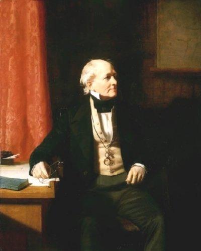
11. The man who sat for the portrait shown in the photo accompanying this article achieved everlasting fame for something related to surface winds. Who was this man and what was the “something related to surface winds”?
Super Bonus Question:
12. NOAA has identified the ten windiest cities in the United States. They are listed below. Tell which is closest to a National Park-designated unit of the National Park System (remembering that just 58 of the National Park System's 392 units are National Park-designated). Also name the National Park.
Blue Hill, MA
Dodge City, KS
Amarillo, TX
Rochester, MN
Cheyenne, WY
Casper, WY
Great Falls, MT
Goodland, KS
Boston, MA
Lubbock, TX
Answers:
(1) True. South Dakota’s Wind Cave National Park is the only unit of the national Park System with wind as a part of its official name.
(2) False. Prevailing southwesterly winds have dictated the orientation of the dunes at Great Sand Dunes National Park and Preserve.
(3) False. The warm, light air of summer afternoons tends to rise, creating a warm upslope “valley breeze” in mountain valleys like those of Glacier National Park It’s the cool, dense air of the night that flows downslope in the valleys, creating the chilly “mountain breeze.” Of course, storms and other weather systems passing through may prevent these diurnal effects from occurring.
(4) True. Although you might reasonably think that the windiest month in this notoriously windy place should occur during the hurricane season (June-November), NOAA weather statistics for Hatteras Island reveal that February (average wind speed 12.2 mph) narrowly beats out March and January (average wind speed 12.0 mph).
(5) True. Although the title may actually belong to Bodega Head or another nearby locale, the Point Reyes Peninsula is often referred to as the windiest place on the Pacific Coast of the coterminous states. That’s not to say that Point Reyes records the highest wind gusts of any National Park System unit in the region. That distinction may belong to Olympic National Park, where winter gusts atop aptly-named Hurricane Ridge commonly exceed 75 mph.
(6) True. Wind Cave exchanges air with the outside according to differences in atmospheric pressure. Air flows out of the cave when the outside air pressure is lower (as during summer days when outside air is warm and light), and into the cave when the outside pressure is higher (as during the night when outside air is chilled and dense). Similar winds occur at the geological blowholes in Arizona's Wupatki National Monument.
(7) False. In Acadia National Park, as in much of New England, lakes are commonly referred to as ponds. Since the two terms don’t distinguish water bodies by size, some interesting anomalies exist. For example, in Acadia National Park windsurfing is banned on Eagle Lake, but permitted on Long Pond.
(8) False. Oregon Dunes National Recreation Area is not a National Park System property. Anyway, the U.S. Forest Service, which administers the property as part of the Siuslaw National Forest, conditionally permits ORV driving on the dunes.
(9) False. Strong and gusty Kona winds, which are opposite in direction to the northeast trade winds, bring unusually warm and muggy conditions to the Big Island. Locals hate the Kona winds, and so do visitors from the mainland who have been primed to expect more comfortable weather.
(10) a – "Eolian” refers to the wind’s ability to shape the earth surface. This includes the ability to create the landforms called sand dunes.
(11) This is a portrait of Rear Admiral Sir Francis Beaufort (1774-1857), inventor of the Wind Force Scale. Commonly referred to as the Beaufort Scale (pronounced BOW-furt), this is a simple empirical technique for estimating surface wind speeds by observing the wind’s visible effects. The original version was designed for naval application in the days of sailing ships. The modern, more widely applicable version uses observation of rising smoke, tree branches, waves, wind-tossed debris, and other phenomena.
(12) Cheyenne, Wyoming, gets the nod here, being only about 90 road miles from the eastern (Estes Park) entrance of Colorado's Rocky Mountain National Park.
Grading: 9 or 10 correct, rest on your laurels; 7 or 8 correct, pretty darn good; 6 correct, passable fair; 5 or fewer correct, nothing to brag about.


Add comment