The human history contained within the reach of the canyon and its branching arms and on its wash bottoms reflects a vital, tenacious period of settlement in the history of the Southwest. For nearly 5,000 years the main and side canyons of Canyon de Chelly have been occupied, the longest continual stretch of habitation on the Colorado Plateau, according to the National Park Service.
That's pretty impressive, particularly when you consider the settlements at Mesa Verde and Chaco Canyon. But it has not been without hardships beyond simply trying to survive in this demanding landscape. In fact, the ancestral Puebloans left the canyons in the middle of the 14th century in a search for more arable land. Hopi then moved into the region and used the canyon sporadically, until the mid-1700s, when the Navajo arrived, driven out of other areas of the Southwest by Utes.

Remaining cliff dwellings speak to the architectural skills and protective nature of the canyon's inhabitants/Kurt Repanshek photo
The canyon's name descends, somewhat awkwardly, from a Navajo word, Tségi, that was mispronounced by Spanish explorers and then English speakers, who pronounced it as de Chelly (d'Shay). Tségi translates into "rock canyon" or "in a canyon," according to Campbell Grant's 1978 book, Canyon de Chelly: Its People and Rock Art.
A Spaniard, Lt. Col. Antonio Narbona, rode into the canyon in January 1805 to scout it for troops back in present-day New Mexico. He attested to the defensive attributes of the canyon in his report to Gov. Fernando Chacón.
"The Cañon de Chelly I scouted from its beginning to its mouth. It is the fort on which the Navajo Indians had based their hopes of making themselves invincible, and as it is inhabited by many people, and fortified by nature with the cliffs that form it, that hope is not without reason, and although on this occasion, I disillusioned them of it, in spite of this I can do no less than make known to you in fulfillment of my obligation and without omitted anything, that if it should be necessary in the future to return to attack it, it would be indispensible that it be with more men than I had and a great supply of ammunition, for that which I brought from my province exceeded ten thousand cartridges, and in order to get out of the said canyon I was forced to use almost all of them."
More pressure on the region came in the 1800s, as exploration of the Southwest by whites accelerated beyond fur-trapping endeavors, in part as a result of efforts to find ways west. We know they arrived at Canyon de Chelly at least by the mid-1800s, evidenced by a lithograph of the canyon made by Richard Kern in 1849.
Drawings transformed into photographs by the 1870s, when a grainy, somewhat distant photo of White House Ruin on a north wall of Chinle Wash by Timothy O'Sullivan appeared in Geographical Surveys West of the One Hundredth Meridian. One of the darkest chapters of the canyon falls between that Richard Kern lithograph and the Timothy O'Sullivan photo.
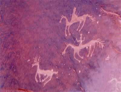
Stories in stone can be found on the cliff walls of the canyon/Kurt Repanshek
Near the end of the Civil War, In 1864, troops in the Southwest led by Kit Carson were assigned the task of putting down raiding tribes. To wrest control of the region from the Navajo, the tribe was "to be harassed through the summer and fall, crops were to be destroyed, livestock captured or killed, and houses burned," notes Grant in his book, a book many canyon guides use as a primer.
In early spring of 1864, troops descended into Canyon de Chelly on a scorched-earth mission, cut down thousands of fruit trees, and rounded up the Navajo to drive them on "the Long Walk" to Bosque Redondo in New Mexico where a reservation had been carved out. Yet just four years later a treaty allowed the Navajo to return to much of their homelands, including Canyon de Chelly.
For a deeper understanding of this period of conflict, and for a great history of Canyon de Chelly, look for a copy of Grant's book at the park visitor center.

