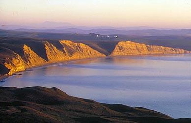
California’s Fish & Game Commission has approved marine protected areas and “no disturbance” special closures that will bring more coastal waters under National Park Service jurisdiction off Point Reyes National Seashore and Golden Gate National Recreation Area. When they go into effect in February 2010, these new protected areas will significantly enhance the Park Service’s ability to manage ocean habitat to the benefit of the fish, waterbird, marine mammal, and other wild species that live in, nest, and migrate through these coastal waters.
California has a long, but spotted history of marine conservation. Overfishing, pollution, coastal development, wetlands loss, and related problems began to seriously degrade California’s coastal waters and marine ecosystems more than a century ago. Early efforts to halt and reverse the damage, including the creation of a half-dozen marine protected areas along the California coast in the early 1900s, were ineffective. By 1950, the early MPA’s were all gone and no science-based process for creating new ones existed. Thus, while more than 50 MPA’s were created in California during the second half of the last century, most were too small, too narrowly focused (one or a few species), and too poorly managed to be of much good.
As the century drew to a close, California’s disjointed collection of MPA’s protected less than one percent of the state’s coastal waters and provided no protection at all for marine resources in deep water critical to the health of nearshore marine ecosystems. The glaring inadequacies of the existing MPA’s could no longer be ignored, so in 1999 the state legislature enacted the Marine Life Protection Act. The MLPA called for scientific studies to evaluate the current state of California's coastal waters and ordered the creation and management of a more comprehensive MPA network for protecting marine habitat and marine species along the state’s coastline.
The California Department of Fish and Game (CDFG) was directed to establish and manage the MPA network. It was decided that the network of new MPA’s would be created in phases. A CDFG program called the Marine Life Protection Act Initiative divided the 1,100-mile California coast into five regions. Each region was slated to get its new MPA’s in its turn: Central Coast (2004-2007), North-Central Coast (2007-2009), South Coast (2008-2009), North Coast (2009-2010), and San Francisco Bay (2010-2011).
If all goes as planned, by 2011 there will be a network of marine reserves, parks, conservation zones, and recreation areas along the entire California coastline, including San Francisco Bay.
Being first in the queue, the Central Coast, which extends from Pigeon Point in San Mateo County south to Point Conception in Santa Barbara County, acquired 29 MPA’s in 2007. Together they protect around 204 square miles of coastal waters.
The MLPA Initiative then focused on the North-Central Coast region, which extends roughly 200 miles between Point Arena in Mendocino County and Pigeon Point in San Mateo County. Following two years of studies, planning, and public vetting, the Fish and Game Commission adopted a plan that provides for 24 new MPA’s in the North-Central Coast region.
As of February 2010, a total of about 153 square miles of state and federal coastal waters in the region will be protected in the form of state marine conservation areas, “no-take” state marine reserves (fully protected), state marine parks (some harvest allowed), and “no disturbance” special closures protecting marine bird and mammals in zones extending as much as 1,000 feet offshore.
The two national parks in the North-Central Coast region will benefit significantly from the marine resource protection provided or facilitated by the new MPA network. Mindful of this, the Park Service has been extensively involved with the MLPA Initiative. NPS personnel attended numerous public meetings (38 were held), helped to draft proposed MPA’s, served on the scientific advisory team, and conducted education and outreach initiatives. The Park Service also provided three years worth of funding for MPA monitoring.
The Park Service should be well pleased with the outcome for Point Reyes National Seashore. Coastal waters abutting the park will soon have five new MPA’s (two of them fully protected) and three “no disturbance” special closures for marine bird and mammals colonies. The newly created MPA’s will cover waters up to three miles seaward, greatly boosting Park Service jurisdiction that currently extends just a quarter-mile offshore.


Add comment