
If you were looking for the tallest native hardwood tree in temperate North America, where might you begin? A group of dedicated volunteers from the Native Tree Society has found the answer, and it's in the Great Smoky Mountains National Park.
Members of the Native Tree Society (NTS) are described as "tree hunters ... a group of outdoor enthusiasts, hikers, climbers, adventurers, artists, and scientists obsessed with exploring the forests and woodlands of the world." One of their current projects is a multi-year effort to locate and measure large tuliptrees (Liriodendron tulipifera) in the Smokies, and their work is certainly paying off.
In April 2011 a team from the NTS hiked into a remote section of the park to check out a promising tree previously discovered by Ian Breckheimer while he was a graduate student at the University of North Carolina. The four-mile hike wasn't a casual stroll'accurately measuring a potential record-setting tree required hauling a lot of heavy gear across very steep terrain.
If you've ever hiked in a forest of large mature trees, you'll understand the challenge in picking out which one is the tallest, but after a bit of looking, team members Will Blozan and Michael Davie simultaneously spotted the tree. "This time," Blozan said later, " it was obvious! It was also a lot bigger than I imagined, especially in the crown."
Was This Tree A New Record?
The then-current record to beat for any tree in the eastern U. S. was 188.9 feet, so a preliminary measurement was taken from the ground. The result was cause for considerable excitement: over 190 feet! Now, however, the real work of accurately documenting the tree lay ahead ... and it was not a quick and easy task.
Foresters have long used several methods to estimate the height of trees without ever leaving the ground. Each of these approaches employs sighting devices, such as laser rangefinders and clinometers, plus some basic trigonometry. There's always room for error in such methods'and even a small error isn't acceptable if your goal is to accurately document a possible record.
The solution? Just climb the tree'and do it in a way that won't damage the tree itself.
Expert Tree Climbing Techniques
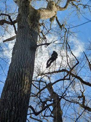
That's easier said than done when you're talking about a tree in a remote location that's roughly the height of a twenty-story building'and there are no branches anywhere near ground level. The climbing spikes sometimes worn by loggers and tree crews aren't an option, because those devices damage the tree bark and provide an avenue for decay and infection to enter the tree.
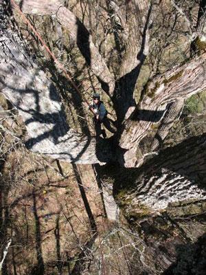
Will Blozan on first ascent of the big tree. Photo by Ian Breckheimer, NTS.
Some NTS members have solved that problem by becoming experts in another way to climb a tree, using non-damaging techniques and equipment borrowed from mountaineering.
In most cases, the first step is to use a very strong arm or a giant slingshot to throw or "shoot" a weighted bag tied to a thin rope over a stout limb, as high in the tree above the ground as possible. The path from the ground to that limb needs to be free of obstructions, and if all goes well, the weight then falls back to the ground, carrying one end of the attached cord with it. The cord is then used to pull a climbing rope up and over the limb and back to the ground, where both ends of the rope are secured.
The tree climber can then ascend the rope, rather than the tree itself, using a climbing harness and mechanical devices that grip the rope. This is a technique that requires considerable skill and stamina'and a careful size-up of the tree for hazards, such as dead branches.
Once the climber has reached the point where the rope crosses the major limb, he or she climbs higher in the tree, using branches and safety lanyards. Once the tree limbs become too thin to safely support the climber's weight, he hauls up a tape measure and drops one end to the ground, measuring the height of the tree from the climber's location.
How To Measure A Very Tall Tree
The final measurement from the climber's location to the top of the tree is made with a series of measuring poles, which are extended until the top has reached the highest point in the tree. This pole is then lowered to the ground and measured; the height of the tree is the sum of these two figures: the tape and the length of the measuring pole. Once those tasks are completed, the climber rappels down the rope to the ground, and the rope is retrieved.
Girth measurements are often taken at several different points on the tree as the climber descends. These measurements can be used to calculate the volume for the tree trunk, adding additional information to the scientific database.
This whole process isn't as easy as it may sound, and in the case of the unusually large tree in the Smokies, there was an additional challenge. The first suitable limb for attaching an ascension rope was an estimated 160 feet above the ground. That's simply out of range for either a hand-thrown weighted line or even a slingshot. Ingenuity and good planning overcame the challenge, since Blozan had anticipated this problem well in advance of the trip.
Ingenuity Saves The Day
With the help of his son Aven, the expert climber built a pneumatic throw-weight launcher, which uses compressed air from a bike pump to propel a 12-ounce throw-weight with a thin line attached to the weight. In tests, this ingenious tool had launched the throw-weight and line 300 vertical feet... but how would it fare deep in the woods?
Team member Nich Maidment at top of the main trunk. Photo by Will Blozan, NPT.
"I located a spot with a clean shot to the intended branch fork," Blozan noted. "As most arborists familiar with tall tree climbing know, the first shot is always a 'calibration shot' and often results in a deployment tangle nightmare of throwline. I had full intention of a blown shot, so while the others were getting out their cameras to film the 'real shot,' I opened the valve."
"Much to everyone's surprise the bag sailed cleanly through the intended fork and clear out the other side of the tree! With a bit of finagling with some minor tangles the tree was rigged. A single shot rigged the tallest tree yet climbed in the eastern US!"
After a preliminary climb to size up the tree and determine the best approach for the work, the rope was left in place overnight, and the team retired to their base camp.
A second day's effort would be required to complete a full set of measurements. "We were anxious to know how tall the tree actually was," Blozan wrote. "The 'Boogerman Pine' [also in Great Smoky Mountains National Park] at 188.9 feet was the number to beat. The pine has had the reign as the tallest eastern tree since 1995. Well, the Boogerman has been surpassed. The tape drop of the great tuliptree was 191.9 feet!"
A New Record Confirmed
"This is the first tuliptree ever accurately measured to exceed 190 feet (57.9 m) and it now stands as the tallest native broadleaf tree known in all of temperate North America- surpassing a black cottonwood (Populus trichocarpa) in Olympic National Park by over 10 feet (3 m)!"
Additional measurements were made during the second day of this tree and others in the immediate area, including modeling of the total volume of the tree and documenting the DBH ("diameter at breast height"), a standard basis for measuring standing trees.
The site is obviously prime habitat for big trees. The DBH for the new record-setting tree was a whopping 67.8", and a survey of a half-acre circular plot surrounding this giant found seven additional tuliptrees with a DBH of 41 inches or more. How long will this new record stand? Members of the NTS aren't sure, and they were impressed by this old-growth stand in the North Carolina mountains.
Blozan notes, " ... the climb of [this]... tuliptree is the beginning of a new understanding of the species. It is also the tip of the iceberg'and it is quite likely that we have not found the tallest one yet... taller trees may be out there. They are remote and it will take some serious effort to document them all."
Most of us would rate the work already completed as some pretty "serious effort"!
If you're interested in more information about the Native Tree Society, including current and past projects and ways you can get involved, you'll find details on the organization's website. It's not necessary for you to climb a tree to lend a hand.


Comments
Interesting article. Has airbourne Lidar been used to verify and/or find these giants? I think dense airborne Lidar data is in the public domain for the Great Smoky Mtn NP. The classified point cloud will contain the top of vegetation return as well as the bare earth returns.
I hadn't read this article before, and found the step-by-step recounting to be fascinating.
Roy--
I know of ~1m pixel last-returns Lidar data from a few years ago for GRSM, but I didn't think that flight also collected first returns for canopy heights (I'm pretty sure it didn't have the bandwidth to record full returns @1m nominal pixels). One of the Toms at the park would know, as he spent some serious quality time on the last-returns trying to construct a better DEM than the 10m pixel available from USGS. I'll ping him tomorrow. Given they're funded for an improved vegetation map, I agree that canopy heights would be useful supplemental information. Neither my job nor his to generate the canopy heights, but he has mad skills and might do it on the side.
Why in the world would they physically climb the tree? These days you can buy a flying drone with a camera for $50. It would be relatively easy to set one up with a calibrated height measurement, fly the drone to the top of the tree and measure the height.
Where's the fun in that?:)
Houston--
Look at the article again. When the survey was done in April 2011, even small expensive drones weren't widely available, and I don't think any were capable of flying up through the branches in that forest.
Second, UAVs (drones) are illegal to fly over Naional Park Service lands, with a few specific exceptions such as for search and rescue at Grand Canyon (where they greatly reduce the risk to SAR folks by finding the body and confirming whether the victim is alive or dead, preventing risky actions for victims already dead). The public can't fly them, NPS scientists can't fly them. That _will_ change, but there need to be rules & policies on whak kinds of management information and issues might justify flying UAVs, and what rules will minimize the impact to wildlife and to visitor experience. But the ability to fly RGBd and other sensors over sensitive areas like wetlands or geothermal crusts is so compelling in terms of better data and less damage than boots on the ground, that managers are working on tht policy guidance, and they will be allowed in the next year or 2. They might only fly at 6am before visitors swarm the park for both visitor safetly and minimizing visitor impacts, but they will be allowed in some situations.
And, I'm not so sure how easy it would be to get accurate heights out of even a $300 drone. I know what I'd want for the rangefinder sensor (probably just a reflector on the drone shot at by 3-4 rangerfinder lasers on the ground), but I'd still need a good horizontal camera to get the drone at the top of the tree.
As a followup to my March comment, I didn't ask the smart Tom at GRSM to play with the lidar. He's way over-committed on his real job. Maybe a student will come along someday looking for a simple honors or MS project: lidar first & last for a map of canopy heights, then a UAV to spot check across forest types, slope, etc.
Except the chestnut was wiped out by an introduced fungus and not by logging.
I know this is an older comment, but here goes'
My reading of the rules (which are dated before your post) is that they can be approved at the regional level, which includes for scientific study. Of course they don't want lots of people simply flying them recreationally. This article was last updated in 2017: