
Nothing publicizes a trail or park like a book or, better yet, a movie.
The El Camino de Santiago, the pilgrimage trail to the cathedral city in Santiago de Compostela, Spain, was given a great boost by the movie The Way, starring Martin Sheen. What wasn't obvious in the movie is that the pilgrimage can be started almost anywhere in Europe. All trails eventually lead to Santiago de Compostela.
I spent a month walking a French pilgrimage trail, Le Chemin de St. Jacques, which goes from Le Puy-en-Velay in southeastern France to St. Jean Pied-de-Port on the Spanish border. The route follows the GR (Grande Randonee) 65, a French national trail.
The Way of St. James
Pilgrims have been walking to Santiago for more than 1,000 years. The remains of St. James the Apostle supposedly are buried in Santiago in northwestern Spain. St. James had spent some time evangelizing in Spain but was beheaded by the Romans when he returned to Rome.
Miraculously his body was returned to Spain, buried and forgotten. His grave was discovered and authenticated in the ninth century. A cathedral was built over the site of the tomb. A scallop shell has come to symbolize the Way of St. James pilgrimage, probably because early pilgrims brought back seashells as souvenirs from Santiago. Some point out that a seashell is also the right size for scooping up water and using it as a makeshift bowl.
Now the trail from Le Puy (via Podiensis) is the main French trail (Le Chemin de St. Jacques) that feeds into Spain. But a modern map shows that Europe is honeycombed with trails that lead to Santiago. You can walk from Norway or the Czech Republic on a pilgrim trail, proving my favorite motto: No place is too far to walk if you have the time.
Officially, you're walking a French national trail, but it's not the Appalachian Trail or the Pacific Crest Trail. It's more like the Mountains-to-Sea Trail across North Carolina, but with an abundance of lodging options. The trail goes through forests, farms, and tiny villages. This is a trek, halfway in difficulty between day hiking and backpacking. You carry everything you need on your back, but you stop at a hostel, hotel, or bed-and-breakfast each night. So you don't need a tent or sleeping bag.
More than 50,000 people start from Le Puy every year. People walk the GR 65 for at least three reasons. For some, it's a religious experience; they enter every church, cross themselves, and whisper a little prayer. Other walkers give reasons that are more spiritual. They're on Le Chemin at a time of transition, after university, losing a spouse, or trying to decide what to do next with their lives; they want to do some thinking. But most are doing it as a hike, a vacation, a way to reconnect with their family and childhood friends who may now live all over the world but get together each year to walk a section of trail.
The 440-mile trail is usually segmented by its large towns. Here are some highlights of the first half of my trek.
Le Puy to Conques
Two trains take us from Paris to Le Puy. The cathedral, Our Lady of Le Puy, dominates the town, the official start of Le Chemin. My husband and I are not in tourist France but in La France Profonde (deepest France). Le Puy is the center for hand-made lace. In one shop, the owner shows us pictures of her mother and grandmother working on lace.
When we get into town, we walk to the cathedral; up, up, up on cobblestones, which are very hard on my feet. Then 134 steps to the entrance of the cathedral. I should have worn my boots. A statue of a black Madonna, Notre Dame de Puy, sits on the altar. A monk in a white robe prays using an iPad for a bible. We walk back down to the city center, trying to follow the white and red horizontal blazes, the sign for the GR65 and all the French national trails.
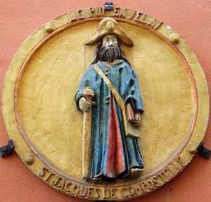
Plaque of pilgrim during the Middle Ages
In the square, a large plaque shows a typical pilgrim of the Middle Ages with a long robe, a hiking stick, and a satchel that probably holds his bible. During the Middle Ages, most pilgrims depended on the kindness of villagers for their room and board. I won't be wearing this costume, just my regular hiking clothes.
The first hiking day, we plan on 14 miles, which might sound tough in the mountains of western North Carolina, but it's not here in the rolling hills of the Haute Loire. This section is not a solitary trek. We must have passed and been passed by 100 hikers. White and red bars mark the trail perfectly. A third bar shows turns. If you aren't sure, a red and white X shows the wrong way as well.
The trail is mostly on dirt paths between farms with cows and a few horses in the fields. Corn and wheat are about to be harvested in other patches, reminding me that France is still an agricultural country. Crosses pave the way, especially at the entrance and exit of each village, encouraging you on your pilgrimage.
We stop for lunch in front of St. Roch, a beautiful little church. Locals have left water as their contribution to "trail magic." St. Roch was the patron saint of pilgrims, along with St. Jacques. As the story goes, he contracted the plague in the 1300s while he was healing the sick on a pilgrimage.
It's impossible to understand and explain the meaning of each church and cross. Every hamlet has both, some in abundance. But I enjoy them as a modern-day hiker and pilgrim. We get into our room by 3 p.m., not bad for 14 miles. A beer for Lenny and a pot of tea for me to keep us going, since dinner isn't served until 7:30 pm.
Every bit of land is used, farmed, or built on with extensive gardens--this is not untouched wilderness. Field and roadside flowers line the trail. Queen Anne's lace is the quintessential road flower, but I can identify purple thistle, clover, harebells, violets, cornflower, and wild raspberries that have almost dried up.
A few days later, we reach the Aubrac plateau, the highest point on Le Chemin at 4,300 feet. It's best described as high moor country, complete with pink heather and almost no trees, just cleared pasturelands with dairy cows. The scenery and stone walls reminds me of Northern England. But unlike the preciseness of British rock fences, these rock walls seem as if they could tumble down as soon as you touched them.
The few stone buildings we pass may have been herders huts in the past but they have long been abandoned. Now farmers check on their cattle with their pick-ups and go back home for lunch.
I know that this scenery isn't natural, that the land has been cleared centuries ago to create these grassy fields. Yet the walking feels wilder than if I were on a Smokies trail between two sets of trees. I can see for miles and keep taking pictures, as if the next picture is going to be better than the last. At this high altitude, flowers familiar from the Smokies such as fireweed and gentians dot the landscape.
Route de la Chaze, a small village, has a beautiful church, but not enough residents to warrant a priest these days. As I understand it, a traveling priest comes every three months and the church stands empty the rest of the time, except for visitors and pilgrims. The only restaurant is for sale.
Other hamlets are almost dead, without even a cafe. We reach Nasbinals, a town with 500 residents, which feels large and full of life. It has a large church and a World War I memorial in the town square, several restaurants, and at least two hotels.
I've searched out war memorials in every village.
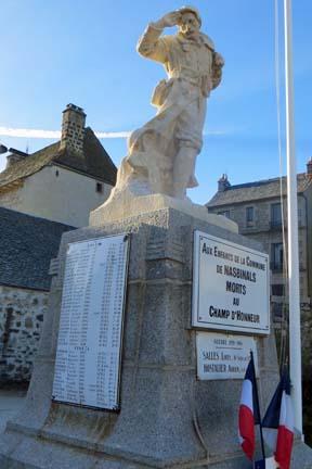
Nasbinals World War I War Memorial
They're very poignant. So many men died in World War I. The memorials take over the town square. In addition, the names are listed in the church; many names for such small villages. France suffered casualties way out of proportions to its size. They really did think that it was the war to end all wars.
The monuments may have a couple of names for World War II tacked on as an afterthought, along with a few more for the Algerian War of independence (1954-1962)--a war that the United States managed to stay out of.
Local restaurants boast that they serve local cuisine, which I learn means heavy on meat and cheese. The specialty in the Aubrac region is aligot, a dish made with potatoes, cheese, butter, cream, and garlic. There's so much cheese that the dish develops a stringy consistency when you serve it out. It's like trying to spoon out chewing gum.
Conques, a tiny medieval village, is a destination for many. The whole village is a historic monument and most visitors have never heard of Le Chemin. Conques and the Cathedral of St. Sainte-Foy (Saint Faith) became famous when the remains of St. Foy, a young female martyr, were transferred here. St. Foy was tortured to death by the Romans in the early fourth century. Once the cult of St. Foy spread and miracles happened in Conques, the current huge abbey was built. Like almost all Catholic churches, the building is open during the daytime. Everywhere you look, spaces are filled in with statues, sculptures, reliefs, and explanatory signs for you to take in.
In the evening, a monk gives a talk about the doorway of the abbey, the Tympanum, which displays the Last Judgment in exquisite detail. Afterwards, he may play the organ. For six Euros ($8.21), you can go upstairs to the gallery level and walk around past more statues and crosses while the music reverberates throughout the church. It's magical.
Many people leave the trail here, including Lenny, my husband who's heading back to Paris and then home. I'm now on my own. 125 miles done, 315 to go.
Conques to Cahors
The first 125 miles were hilly, maybe as much as 2,500 feet of altitude gain, which over 15 miles isn't much. Now, my altimeter barely registers 1,000 feet and I stop logging the ups and downs. The trail has come down to below 1,000 feet in elevation. The bushes lining the trail, gorse, broom, and multi-flora roses have become invasive plants in the U.S. They were introduced as ornamentals and now are very difficult to eradicate. But Le Chemin has at least one invasive of its own, the Himalayan balsam (Impatiens glandulifera), a beautiful pink and white flower that reproduces aggressively, especially near riverbanks.
As I keep plodding on, I appreciate the Chemin experience more and more. I stop at every sign of hospitality. Residents on the trail offer coffee and tea for one euro, tiny cups that you can swallow in two gulps. But I figure that for one euro, I get a table and chair to have my lunch, a garbage can, and sometimes an outhouse. It's a bargain.
Walkers come and go on Le Chemin. Though I walk alone during the day, I reconnect with pilgrims at the gite (hostel) in the evening. I spent a night at the gite, Le Pech, up on a hill where I had a typical pilgrimage experience. Two German women needed a reservation for the next night. They didn't speak French and only a little English. So I translated their request into French to a guy who called up and made the reservation for them.
"Pech" means hill in Occitan, a historic language. Most of southern France spoke this traditional regional language before the country standardized on current modern French. Like most of these local languages (not a dialect or patois), no one speaks it anymore, but you can study it in schools.
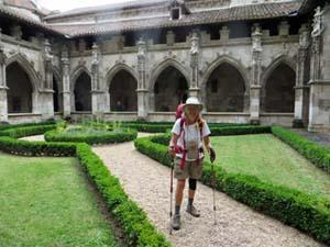
In the cloisters of the Cathedral of St. Etienne
Cahors, with a population of more than 20,000 people, is the next big destination on Le Chemin.
The city is a peninsula, almost encircled by the Lot River. I reach Cahors just before the Saturday food market closes and buy my lunch supplies for the next couple of days. The Cathedral of St. Etienne is the big draw for tourists but I lose myself in its cloisters. Imagine spending your whole life seeing the sky from this tiny garden.
Two-hundred-and-four miles done.
Next week: Two-hundred-and-thirty-six miles to St. Jean Pied-de-Port.


Comments
Danny - what a great trip! Thanks for giving us some perspective on a rather different type of long-distance hiking that we find in the U. S. I'll look forward to the next installment :-)
This is definitely one for the bucket list. Your descriptions are wonderful.
A puy is the local name for the top of a volcano. The mountain in central France (Massif Central) is full of puys which represent just as many extinct volcanoes.
I enjoyed your article. Thanks for posting it.
I go to Le Puy 04 Sep 2016. Thanks for your article!
My brother and I plan to hike from Le Puy to St. Jean this summer. Do you know of any useful guidebooks in English? Thank you.
I walked the Via Podiensis from July to September 2018 (Le Puy to Compostele). You can read my notes at wherespadre.org I hope you enjoy it!