You are here

Landslide Closes Gunter Fork Trail In Great Smoky Mountains National Park

Share
Alternate Text
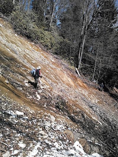
The Gunter Fork Trail has been closed indefinitely by a landslide./NPS

A landslide has closed the Gunter Fork Trail in Great Smoky Mountains National Park indefinitely.

The slide occurred in the same area where a 2011 slide also closed the trail.

The 4.1-mile-long trail lies in the east end of the park, connecting Camel Gap and Balsam Mountain trails. The Gunter Fork Trail is a route that takes users from the Walnut Bottoms area up to Balsam Mountain and Mt. Sterling, but it is not one of the park'™s most heavily used trails. The Swallow Fork Trail provides alternative access to the same areas.

For more information about trail closures, please visit the park'™s website or call the Backcountry Information Office at 865-436-1297.

Add comment

CAPTCHA

This question is for testing whether or not you are a human visitor and to prevent automated spam submissions.

Image CAPTCHA
Enter the characters shown in the image.

The Essential RVing Guide

The Essential RVing Guide to the National Parks

The National Parks RVing Guide, aka the Essential RVing Guide To The National Parks, is the definitive guide for RVers seeking information on campgrounds in the National Park System where they can park their rigs. It's available for free for both iPhones and Android models.

This app is packed with RVing specific details on more than 250 campgrounds in more than 70 parks.

You'll also find stories about RVing in the parks, some tips if you've just recently turned into an RVer, and some planning suggestions. A bonus that wasn't in the previous eBook or PDF versions of this guide are feeds of Traveler content: you'll find our latest stories as well as our most recent podcasts just a click away.

So whether you have an iPhone or an Android, download this app and start exploring the campgrounds in the National Park System where you can park your rig.