Valley of 10,000 Smokes at Katmai National Park and Preserve/Barbara 'Bo' Jensen
Exploring Katmai National Park's Mysterious Valley Of 10,000 Smokes
By Barbara 'Bo' Jensen
Dark, heavy skies threaten to unleash a torrent. Undaunted, the single-engine’s propellor rumbles defiantly and roars to life, promising adventure as my float plane taxis upriver from tiny King Salmon, Alaska, headed for the mysterious Valley of Ten Thousand Smokes at Katmai National Park and Preserve.
This is bush Alaska – isolated and remote. The only real road is the two-lane Alaska Peninsula Highway, 15 miles of pavement between King Salmon and Naknek, a commercial fishing village at the mouth of the Naknek River where it empties into Bristol Bay. To get anywhere else, you fly.
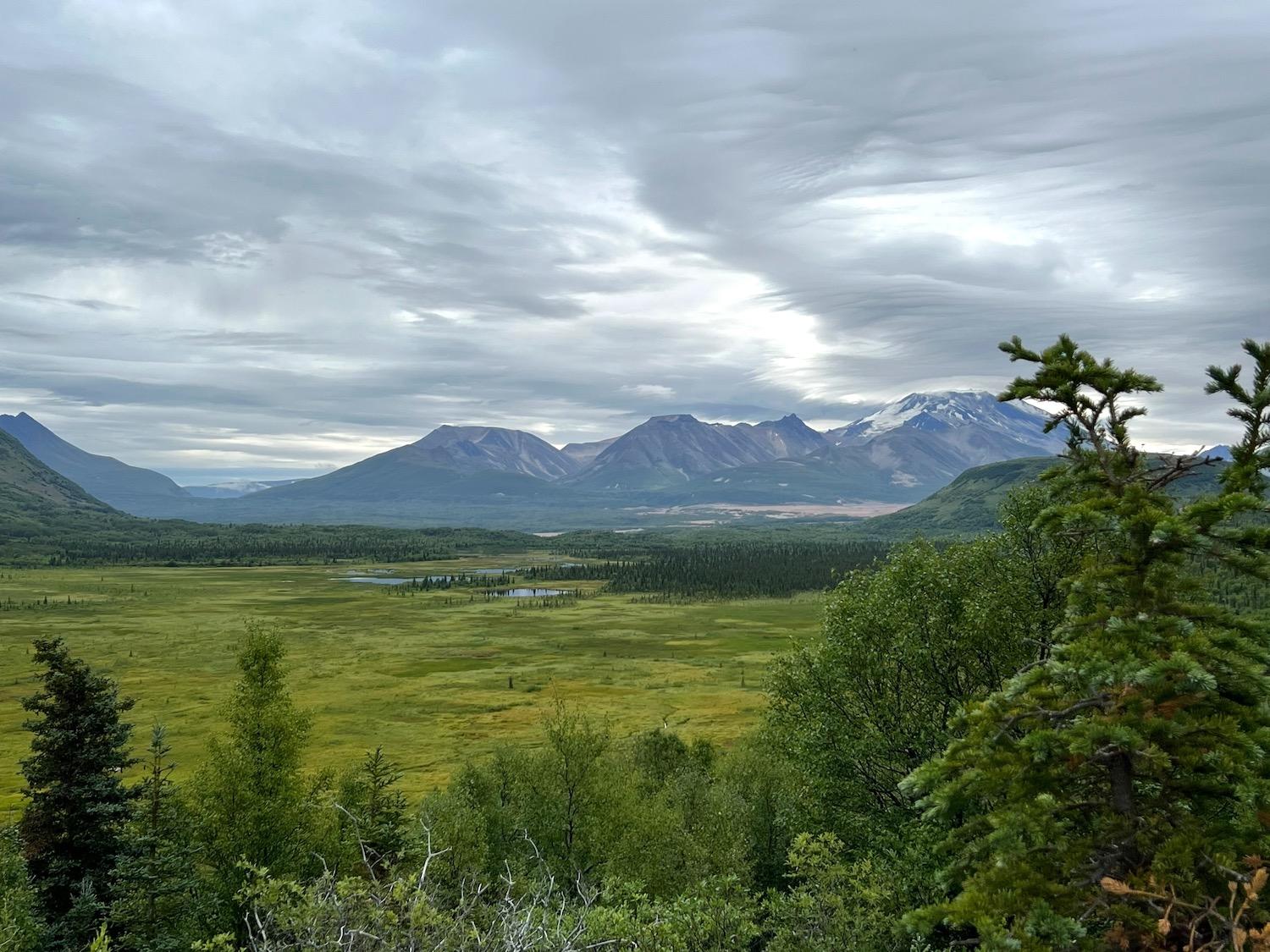
Life here flows upward. Lifting off from the Naknek River, our plane follows the river upstream to its source, 40-mile-long Naknek Lake (the largest lake in the National Park System), soaring over the wet coastal tundra and low-growing boreal forest hugging its shores. We rise toward sudden mountains, fighting a strong current of wind much like the salmon in the rushing waters below. They, too, are headed upstream, from the open ocean into Bristol Bay and upriver to their spawning grounds.
Katmai National Park and Preserve covers more than four million acres, most of it trackless, high mountain wilderness. The weather where we’re going is unpredictable and wild. It’s a great place to score an “Alaska BMW”: sighting a bear, moose, and wolf, all possible in the same place, potentially on the same day.
The volcanic-ash-covered floor of the Valley of 10,000 Smokes at Katmai National Park/Barbara 'Bo' Jensen
After 30 minutes over turbulent waters, we land on the lake at Brooks Camp, site of historic Brooks Lodge since 1922 – and also home to one of the highest concentrations of coastal brown bears in the world. Larger than inland grizzlies due to their rich diet of salmon, these usually solitary creatures are the massive stars of Fat Bear Week in October, featured live from Brooks Falls on Katmai’s online bear-cams. But there’s so much more to Katmai National Park than celebrity bears.
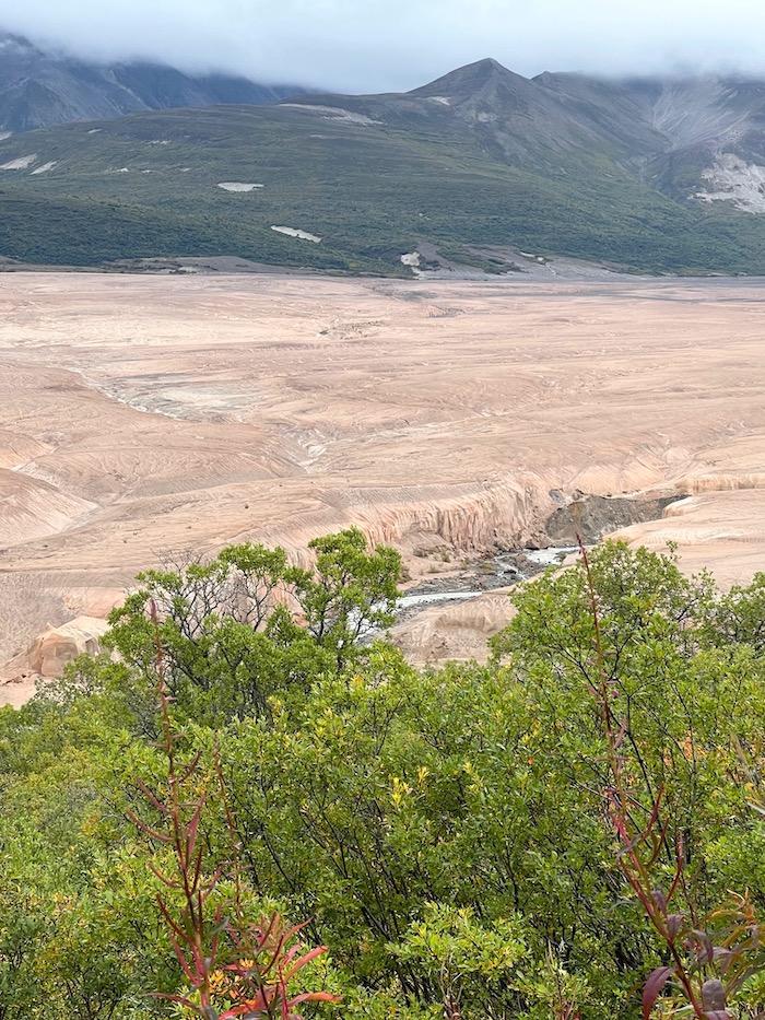
Cycles of destruction and creation – both biological and geological – mark this place. And while the bears are huge, they are ants compared to the primordial power on display at The Valley of Ten Thousand Smokes. At Katmai, the surrounding mountains are revealed as volcanoes, and the great volcanic Ring of Fire is still active under the Alaska Peninsula. On a clear day, you can see smoke steadily rising from the summit of 7,600-foot Mt. Griggs.
After coffee at Brooks Lodge, I catch the Valley tour at 9 a.m. aboard a 4WD-converted school bus. It’s a bumpy ride along 23 miles of muddy single-lane road through tight trees and underbrush, with a couple of shallow river crossings thrown in to keep everyone awake. Our knowledgeable guide is a Park Service ranger. We stop at tour lecture spots along the way, outcroppings with sweeping vistas of marshy green river valleys, glacial moraines covered in mixed forests, lush lower mountain slopes and stunning rocky volcanic peaks towering above.
Earthquakes were well-known to generations of Indigenous people living in the area, and still rattle this part of Alaska regularly. Ancestors of the inhabitants of the nearby Native Alaskan villages Savonoski and Katmai handed down warnings about the mountains that shake the land and erupt with powerful force. When the people of those villages felt the first rumblings in June 1912, and saw the animals and birds fleeing the mountains, they knew to evacuate. They left their villages and survived – and just in time. On June 6, 1912, a vent opened up next to Mount Katmai, exploding with 3.1 cubic miles of magma and ash blown 100,000 feet into the air, darkening the skies for days. That vent would be named Novarupta, the world’s largest volcanic eruption of the 20th century. Novarupta existed above the same magma chamber as the volcano Mount Katmai; the incredible force and internal pressures of its historic eruption caused the peak of Mount Katmai to implode, sucked down toward the chamber emptying below and leaving a two-mile-wide, 2,000-foot-deep caldera that has slowly filled with water over the years. Savonoski and Katmai Village were buried under ash, rendering them uninhabitable.
I’m thinking about the ranger’s incredible stories as we arrive at our destination, the bus creaking and rocking uphill to the Griggs Visitor Center overlook, the end of the road. We clomp down the bus steps in our hiking boots, crunch across pumice and gravel, and then climb the wooden steps to the overlook’s wide deck…and I’m blown away by the stunning panorama before me.
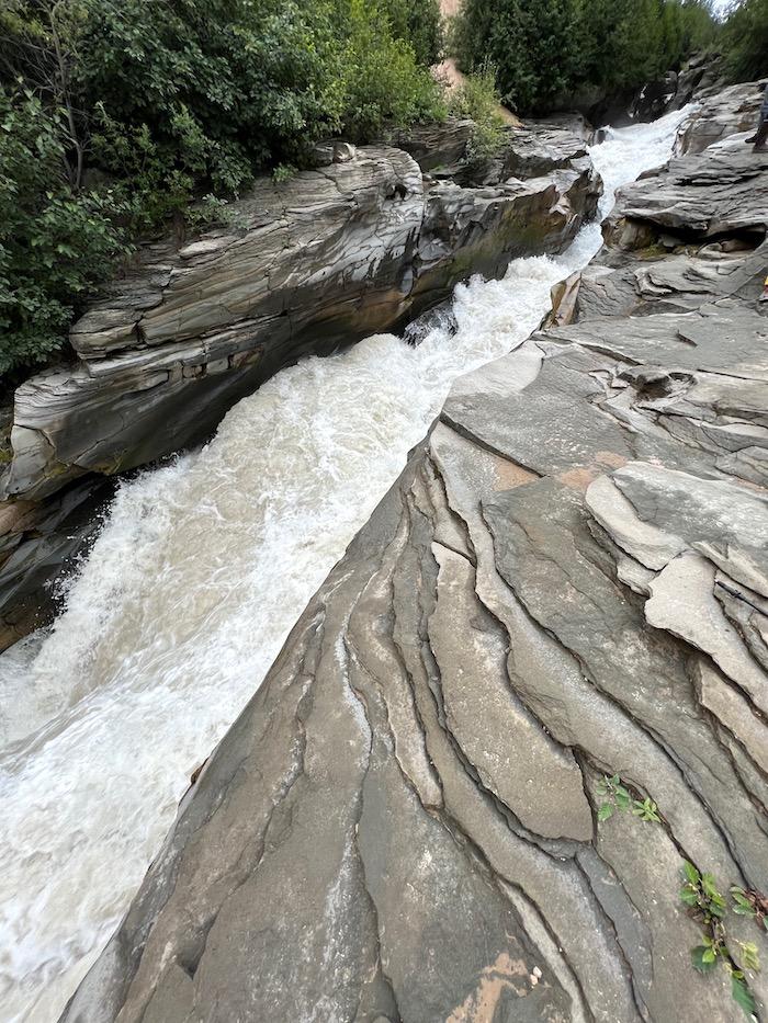
Ukak Falls, Valley of 10,000 Smokes, Katmai National Park and Preserve/Barbara 'Bo' Jensen
Mount Griggs towers to my left, named for the National Geographic explorer who brought attention to this valley in 1916. Its summit is encircled by clouds that bend and stretch over it, so high it is changing the cloud formations themselves and influencing the weather. To my right, the green Boundary Peaks arc like a gathering arm to shield the rest of the high valleys from the view of devastation before me. Because directly in front of me, below the jagged-toothed, broken-topped Mount Katmai, lies 50 square miles of hardened pyroclastic flow: The Valley of Ten Thousand Smokes, where fumaroles vented steam and gas for over 60 years as the valley surface slowly cooled. Surrounded by such lush environs, the barren landscape is startling, a desolate badlands of Novarupta’s making, its orange pumice surface carved by wind and water so that it resembles a segment of the Grand Canyon or the Painted Desert more than it does the nearby tundra of thick peat and low berry bushes.
Our ranger leads us on a 3.4-mile hike, 1,000 feet down into the Valley. We come to Ukak Falls, slicing into the soft, crumbling volcanic stone and now pounding its way over the underlying layers of harder slate. On the way back, I take the side Confluence Trail to where Knife Creek, the River Lethe, and Windy Creek join to form the Ukak River. Here, the ash and fine silt still muddying the river will immediately clog your water filter.
I look for the clear water from the Boundary Peaks. And then I look farther, for a good hiking line to follow into this protected wilderness. Scouting and route planning are critical at Katmai. Backcountry permits and bear canisters for food are required, full raingear and bug headnets are necessary in summer, snow gear as the summer turns, and electric camp fence and personal geolocators are recommended. Plan for disruption – weather-related travel delays getting in and out of the park are common, and once here, bear and moose will claim and alter your hiking path. Bring solid bear safety training and know the difference between a defensive, startled animal and predatory behavior. Consider hiring a local guide. Backcountry mountain survival skills and experience are essential if you decide to camp beyond the park’s fenced tent campground back at Brooks Camp.
To return from the Valley, I must climb up the steep hillside to the overlook. Energy here flows upward, upstream, up the mountains. It’s a fierce place, where nothing comes easy. Yet, as we bounce along in the 4WD bus, emerging back up the muddy Valley Road, I am already imagining a backcountry wilderness adventure among the volcanoes.
Bo Jensen is a writer and artist who likes to go off-grid, whether it's backpacking through national parks, trekking up the Continental Divide Trail, or following the Camino Norte across Spain. For over 20 years, social work has paid the bills, allowing them to meet and talk with people living homeless in the streets of America. You can find more of Bo's work on Out There podcast, Wanderlust, Journey, and www.wanderinglightning.com
Follow @wanderlightning [email protected]
Comments
My wife and I did the same trip in 2007.
It is truly a marvelous place to visit, but the hike up to the visitors center was a grind. I am glad that you had the opportunity to do this trip, and hike.
Bernie Negrin
Excellent writing.