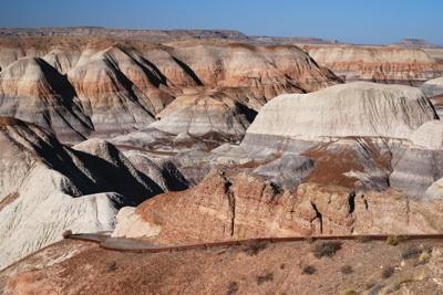
There are, relative to other parks, only a handful of hikes for you to consider when you visit Petrified Forest National Park in Arizona, but you still should come up with a pecking order, if only to plan your day. And if you like to hike first thing in the morning, then the Blue Mesa Trail should rise to the very top of your list.
When it comes to getting the most out of your hikes in Petrified Forest, so much comes down to the slant of the sun. Even small changes of angle from that fiery orb overhead can alter the color of the landscape, and that of the rock logs, on the ground at your feet. What looks spectacular in the morning very possibly could look drab in the afternoon, and vice versa.
When it comes to the Blue Mesa Trail, I found that the fresh morning sun, still on a somewhat low angle, seemed to bring the most out of the colorful scenery to be found on this hike. Surely, by mid-day, with the sun high overhead, the colors wouldn't seem as dazzling.
While late in the afternoon those colors might come back to life, as if freshly remixed, the sun is on its downward trajectory and you could find yourself grappling with unwanted, and growing, shadows caused by the hills above the western side of the loop.
The turnoff to the Blue Mesa Trail is found smack dab at the centerpoint of the park road, falling 10 miles south of the Painted Desert Visitor Center and 10 miles north of the Rainbow Forest Visitor Center. From that turnoff you drive just about 3.5 miles east to the trailhead, where you'll enjoy stunning, and colorful, views of the serrated badlands in this part of the park.
Though just 1 mile in length, the asphalt path takes you down from the mesa top to the floor of the valley and deeper into the Triassic landscape that comprises the national park.
The rutted hills are comprised of mudstones and claystones, with a fair amount of Bentonite clay mixed in, and topped in places by courses of conglomerate gravels. It's the clay, park geologists say, that gives the hills their wrinkled appearance, as it swells up with moisture when rains come and then shrinks when it dries, creating the appearance of "elephant skin."
The trail starts out innocently enough on a fairly straight line, but then bends to the left around a conglomerate-covered hillside before executing a diving zig-zag that takes you down to the valley floor.
Here you can either go right or left on the loop. No matter which route you take, though, you'll be treated to towering hills banded by colorful layers of silts, sands, and gravels left behind by massive Triassac-age river systems that more than 200 million years ago left sedimentary deposits upwards of 1,000 feet deep across the landscape.
Of course, since those rivers vanished more recent erosional activities have carved the park up into the colorful and rumpled place we find today.
Following the trail as it rises and falls slightly across the valley floor, you can't help but notice the countless logs, slabs, and chunks of petrified wood, some seeming as if they were neatly split by some ancient woodchopper before they turned to stone.
Get here early enough after the park gates open at 7 a.m. -- say by 8 a.m. or 8:30 a.m. -- and you're likely to have the trail to yourself, perhaps with only a raven or two watching your progress. Such solitude allows you to walk at your own pace without feeling rushed, stopping now and again to ponder the setting about you and with ample time to marvel at the colors of the petrified chunks of wood.
The wood's colors -- deep umbers, golds, greens, yellows, and beiges -- are in stark contrast to the grays, blues (generated by that Bentonite clay), purples, and browns contained in the surrounding hillsides.


Comments
I just hiked this today, it's a really nice short trail