
Gates of the Arctic National Park and Preserve/NPS
I stumbled across a video the other day that further convinced me that I need to move Gates of the Arctic National Park higher on my to-do list. In it, two septuagenarians set off on a three-week canoe trip down the Noatak River, a river the park staff tells us "drains the largest mountain-ringed river basin in America that is still virtually unaffected by human activities."
The video, produced by The Muir Project, follows two old friends who have been exploring the wilds for roughly four decades. Along with raising a proverbial glass to friendship, the video opens a panoramic window on one of the least-visited, and wildest, parks in the system. Fewer than 12,000 people explored Gates of Arctic last year, and no doubt part of the lack of visitation stems from typically needing a bush pilot to fly you into the park to kick off your adventure.
NOATAK: Return to the Arctic from The Muir Project on Vimeo.
Gates of the Arctic National Park offers a true wilderness experience/NPS
But as glorious as this video is in its celebration of both friendship and the wilds, the magnet that the Noatak River is has created a problem with concentrated visitation. The National Park Service has raised concern over impacts, stating that "lakes at the various put-in and take-out points are receiving heavy camping use (Twelvemile Slough, Portage Lake, Nelson Walker Lake, Pingo Lake and Lake Matcharak). Vegetation around the lakes is being destroyed and the impact is detracting from the area's wild character."
With hopes of minimizing, if not reducing, the impacts, park staff has been urging paddlers to "move directly to the river to camp." After arriving at their put-in, river runners are urged to "(C)amp on river gravel bars. Use existing trails between lakes and the river. Do not build fires on the tundra."
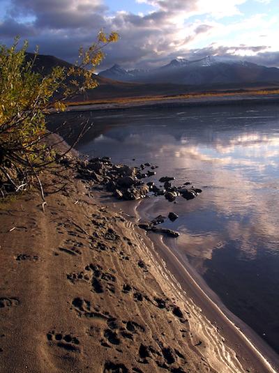
But the Noatak is not the only river to run in the park. There are six rivers tied to this 7.5-million-acre park. If forested landscapes are important, choose the Kobuk River, as it flows through “one of largest continuous forested areas in the Park and Preserve.”
But not everything at Gates of Arctic revolves around paddling. There are more than 13,000 square miles to explore, many on foot. Experience in backcountry hiking and navigating are required if you're hoping to explore this park's vastness. There are no established trails, you might encounter bogs, and while jagged peaks and mountain passes are inviting and can lead to amazing views, you're on your own there.
Birding is popular in the park, which has counted more than 140 species that include raptors, songbirds, and aquatic birds. Visit the park in late August and early September and you have a chance of spotting caribou herds as they head south before winter hits.
The National Park Service has dubbed this park "Alaska's Ultimate Wilderness," and its overview of Gates of Arctic conveys why.
Few landmarks bear names on topographic maps here. The park name came from wilderness advocate Robert Marshall, who traveled the North Fork Koyukuk country frequently from 1929 to 1939. Marshall called two peaks, Frigid Crags and Boreal Mountain, the gates from Alaska's central Brooks Range into the far north Arctic. Wind, water, temperature, and glacial and tectonic actions sculpted wildly varied landscapes in this east-west trending part of the Rocky Mountains. Southerly foothills step into waves of mountains rising to elevations of 4,000 feet that culminate in limestone or granite peaks over 7,000 feet in elevation. Then the ranks reverse at the Arctic Divide: Tundra stretches to the Arctic Ocean. Six national wild rivers - Alatna, John, Kobuk, Noatak, North Fork Koyukuk, and Tinayguk - and other waterways cross the park. many people seek remote wilderness and solitude here. A primary goal of park management is to protect these opportunities.
People have been a part of the ecosystem here for over 13,000 years. Nomadic hunters and gatherers traveled between the mountains' forested southern slopes and the Arctic Coast. Now their descendants depend on and use park and preserve resources. A Nunamiut Inupiat village, Anaktuvuk Pass, lies inside the park. Winter is long, and summer is active. Plants and animals move through life cycles quickly before winter sets in.
From November to March, most activity ceases while -20ºF to -50ºF temperatures persist. The dry interior climate sees little snow, but what falls stays to wrap land and rivers in ice and silence. As the low-riding sun starts its warming ascent in March, dogsledders come out. Backpackers and river runners arrive in mid-June, as the rivers become free of ice. No trails or visitor services exist in the park. You must be self-sufficient.
To get more of a sense of this rugged park, you might want to pick up a copy of Joe Wilkins' book, Gates Of The Arctic National Park: Twelve Years Of Wilderness Exploration. Better yet, track down a copy of Bob Marshall's book, Alaskan Wilderness. That's what Andrew Skurka relied on back in 2010 when he spent six months walking, paddling, and skiing around Alaska. That nearly 4,700-mile, six-month-long odyssey took him through a showcase of national parks: Gates of the Arctic, Glacier Bay, Denali, Wrangell-St. Elias, Kobuk Valley, and Klondike Gold Rush in the United States, Vuntut and Ivvavik in Canada.
"Bob Marshall’s observations are like almost identical to what I came across," Mr. Skurka told the Traveler back in 2011. "The rivers were still running the same way that they used to, seeing a lot of wildlife, the natives up there, their lives have certainly changed, but they’re still up there, they’re still primarily based on subsistence living, at least for the bulk of their food stores, and the landscape up there hasn’t changed that much."
If you're looking for a place to really get away from it all, one that will test your survival skills, Gates of the Arctic would be a good choice.
Traveler's choice for: Wilderness experience, paddling adventures.

Hidden Valley, Gates of the Arctic National Park and Preserve/NPS, Cadence Cook


Comments
Looks incredible!
It is great to see the overview of the area distinctive throughout the National Park System for its wild character and wilderness values. The Gates of the Arctic National Park and the Gates of the Arctic National Preserve are managed as one adminstrative unit as National Park and Preserve.
So one little accurate statement that could confuse: the actual total size of Gates of the Arctic is about 8.4 million acres. I assume your lower number is the "National Park" portion only. But the park purposes in the law for park and preserve are identical. The only difference is, sport hunting is allowed in the National Preserve. Part of the National Preserve is in the far northeast, centered in the high Arctic around the Itkillik River Valley parallel to the pipeline corridor; and in the far southwest, the other portion of the National Preserve is centered on the Kobuk River. People call this landscape 'the Boot' because like Italy it does look like a boot. This country is the subarctic woodland, just below the Walker Lake and the Wilderness boundary. This also is special country, and helps justify the intention that the park and preserve together is an ecological contiuum, from the ecological values of the subarctic to the Arctic. The Kobuk is a large slow moving river that for 10,000 years or more has been the way Native peoples have moved from the coast on the western mouth of the Kobuk to the inland heart of Alaska, in the subsistence round of hunting and gathering.
But all this is threatened. The state of Alaska, through its development corporation, is proposing to build a truck-ore caravan gravel haul road, a gravel road that will cross into the National Preserve boundary in the Kobuk portion, and then over on the southeast, cross the National Park and wilderness boundary at the bottom of the North Fork of the Koyukuk River.
This ore-haul caravan road is being expedited by the Trump Administration and Secretary Zinke. The purpose of the road is to create large open pit copper-lead-zinc mines on the boundary of FOUR national park system unites: The Gates of the Arctic National Park, the Gates of the Arctic National Preserve, the Noatak National Preserve, and the Kobuk Valley National Park. Copper is notably toxic, and you can expect that the wilderness fish species of the Kobuk River will never be the same when its headwaters flow through pit mines.
An agency is required by law to tell the public and decision makers what the comprehensive impact of a project. Yet the Trump Administration in considering the environmental impact of the ore-truck caravan road, refuses to consider the impact of unleasing the pit mining that could not happen without the road. This road will not only cross the National Park and Preserve boundary in two places, but if built will cut the migration route of the Western Arctic Caribou Herd. This is the largest such migrating herd of any kind in the entire United States.
So this road which no one is talking about would completely bisect and undermine the greatest remaining mammal migrations.
This is worse, far worse, than the Pipeline Haul Road, because that route generally is parallel to the routes of the nearby Caribou; this "Ambler" ore-caravan road will cut right across the caribou route.
But a caravan of trucks crossing in front of migrating caribou -- a notoriosly skittish animal -- would likely drive the caribou off in a different direction, away from the habitat those caribou would otherwise have chosen. Of course, the wolves travel with the caribou and would be equally affected, on top of what ever damage to the river and to the people who still live the subsistence way of life and depend on caribou for sustenance. Not just the Kobuk River people, but also the Mountain Innuit of the Village of Anaktuvuk Pass that sits on the continental divide between the Arctic Ocean and Pacific/Bering watersheds. The Village is right in the heart of the National Park and a special value to the Gates of the Arctic. The successful subsistence way of life requires people to have choices to move between a rich variety of hunting and gathering and fishing species based on opportunity and availability: if the vulnerable Caribou herd numbers drop, the people who depend on the herd could find their entire way of life threatened.
Yes, true, the mine and road could bring jobs, and optimistic estimates are the mining could last 20 years or more than a generation. But what when the copper plays out, or the company moves out, the damage to caribou and fish done?
If that is not bad enough, it is a Canadian Mining company with very little capital. They do not have the money to guarantee or bond the cost of building the road, to guarantee the repayment of the costs of compromising one of the last large roadless areas of the United States.
So, on one hand this is a notice that the entire geological unit that is the Gates of the Arctic National Park and Preserve is actually way bigger, and that the Kobuk Wild River goes not through the 'national park' but through the 'national preserve,' but the real message is that the Kobuk portion of the National Preserve is every much as nationally precious and significant as any other part of the Park, and that fully integrated unit and one of the Park's most charismatic wildlife species are facing immediate threat, for the sake of mining of an ore widespread throughout the world, who's commodity value has dropped over 7% in the last Quarter, of a canadian mining company.
COMPLETE DISCLOSURE: when the Alaska National Interest Lands Conservation Act passed on 1980 one of the compromises was to create a process to allow a right of way, a road corridor, across the Kobuk Boot. It was a compromise, because the first demand was to drop the Kobuk River and the Boot entirely from the legislation. But parks from the beginning were often created with resource conflicts. Death Valley for example had mining all over when it was established, but America then decided to get mining out of Death Valley. It looks like Trump-Zinke want to push pit mining and a haul road across the national park and preserve boundary fast before the public realizes what it is losing.
I am doing a research project on this park for my school. I think that this video was incredibly helpful! I would love to visit the park when I'm older!