Breaching Cape Lookout National Seashore
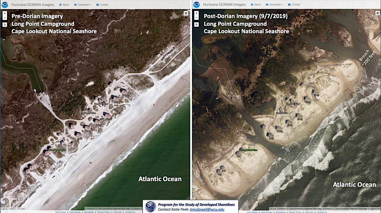
Hurricane Dorian spawned a 9-foot wall of water earlier this month, sweeping across the northern end of Cape Lookout National Seashore on North Carolina's Outer Banks, swamping historic Portsmouth Village, and slicing up the seashore's barrier islands into islets.
"Buildings had water in them, some of the buildings were tipped over, some of them were missing a roof," B.G. Horvat, the seashore's chief of interpretation, said in describing the scene at the quaint fishing and shipping village that has endured hurricanes on Cape Lookout's northern tip since the mid-1700s. "Fortunately, none of the more valuable assets in terms of things were there, because they were all taken care of ahead of time."
Dorian, rated a Category 1, or weakest, storm on the hurricane rating system, turned Cape Lookout and its three barrier islands into an earth scientist's hot spot. While the three barrier islands -- North Core Banks, South Core Banks, and Shackleford Banks -- stretch 56 miles, the hurricane carved more than 50 breaches into those islands, or roughly one every mile.
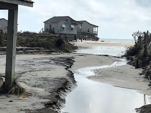
Hurricane Dorian damage to Long Point Cabins at Cape Lookout National Seashore/NPS
Whether those breaches remain open for a month, six months, or seven years -- which is how long the breach cut into Fire Island National Seashore's Otis Pike Fire Island High Dune Wilderness by Sandy back on 2012 has remained open -- is unknown. Some will surely close, some might not. Regardless, it's an incredible show of force by nature that combined hurricane-force winds, rainfall, and storm surge to rearrange Cape Lookout's islands.
Hurricanes accentuate these effects, shuttling veritable trainloads of sand about, shoving around entire barrier islands, and even tearing islands in half.
Barrier islands are tricky things, as they're constantly in motion. These ribbons of sand are ground up, endlessly tumbled, and spit out as geologic remains. In the case of capes Hatteras and Lookout in North Carolina, the sands began as part of the Appalachian Mountains before being eroded away and constantly shipped downstream by creeks into streams into rivers and finally deposited in the Atlantic, where surging long-shore currents constantly rearrange them.
But Cape Lookout stands out in comparison to Cape Hatteras and Cape Cod, as those two national seashores reside on barrier islands that have been heavily built out, while Lookout's barrier islands are dunes and maritime forests and a lighthouse with its adjacent keeper's house. There is no paved road running through the islands, no modern-day villages to lure tourists.
"They’re natural barrier islands, and we haven’t filled them up like our friends to the north, up in Cape Hatteras," Chief Horvat said. "So they’re doing what they’re supposed to do. It’s an incredible event, 54 inlets at once. It’s just amazing. And scientists that have been looking at the area, I can’t imagine what they’re thinking.
"You see a lot of tipping points for climate change around the world, and this seems to be something similar to that," he added.
“As a scientist I think what we would say is Cape Lookout is our 'control.' Cape Lookout continues to remind us what all of the East Coast barrier islands would look like if we hadn’t paved them over and covered them with hotels and vacation homes and things like that. Places like Cape Lookout are absolutely invaluable, both as laboratories for understanding what natural barrier islands are supposed to be and look like, as reserves for the species that need those refuges where there aren’t over-developed shorelines, and to some degree, I think Cape Lookout is the canary in the coal mine, because we can see the degree to which Cape Lookout is beginning to respond very rapidly to storm impacts like Dorian's and I think that that’s a harbinger of things to come for some of the other developed barrier islands on the East Coast.
It’s not going to be as easy as it used to be to hold these shorelines in place like we’ve been doing for the last several decades. At Cape Lookout, fortunately, it’s OK if we don’t hold that shoreline in place. It’s still going to be OK. But for these developed barrier islands, they’re going to be some very tricky issues that they’re going to be dealing with over the next couple of decades.”-- Professor Robert Young, Western Carolina University
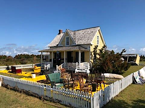
Henry Piggot's house, Portsmouth Village, with the furnishings out in the yard to dry/NPS
Robert Young is one of the scientists studying Dorian's aftermath at Cape Lookout. Director of Western Carolina University's Program for the Study of Developed Shorelines, he and his staff and students long have worked with the National Park Service on coastal studies. At Cape Lookout, he was astonished by what the hurricane did.
“Dorian was not a monster storm. This was a Category 1 hurricane going by offshore," he said. "The way the winds were circulating produced an unusually large storm surge on Cape Lookout for a Category 1 storm. The 'end message' is that places like Cape Lookout, with the combination of repeated storm impacts and rising sea level, are becoming more and more exposed, or susceptible to even a Category 1 or 2 hurricane like Dorian.”
It was a year ago, September 2018, when Professor Young's staff put together a "vulnerability assessment" for Cape Lookout days ahead of Hurricane Florence, which came ashore south of Cape Lookout on September 14 at Wrightsville, North Carolina, as a Category 1 hurricane.
Results of the coastal vulnerability assessment show that over two-thirds of the infrastructure evaluated at Cape Lookout have high vulnerability to coastal hazards, and have a combined replacement value of over $40 million. The highest vulnerability infrastructure is primarily in Portsmouth Village, which is located on the low-lying (within 6 feet of sea level), soundside of Portsmouth Island. Most of the infrastructure in Portsmouth Village are historic buildings in poor condition, built at-grade, and with little storm-resistance. -- Hurricane Florence and the Vulnerability of Cape Lookout National Seashore, Program for the Study of Developed Shorelines.
That assessment proved eerily accurate.
"The early reports that we’re getting from the field indicate that almost all of the structures were damaged to some degree, but some structures (were) a total loss," Professor Young said late last week during an interview. "I think the vulnerability assessment did a pretty good job of giving us something of a preview for what might be at risk long-term at Cape Lookout."
While Cape Lookout, where seashore officials are assessing damage to Portsmouth Village and other areas of their park, is reopening some areas to the public, Young said "the degree of geomorphic change, the amount of sand that’s been lost and the number of breaches across the island, will mean that visitor access is probably going to be a little different in the future than it has been in the past.”
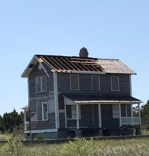
Built in 1907 as a lighthouse keeper's quarters and now known as the Barden House. Hurricane-force winds removed not only the shingles but the underlying decking as well. Due to the height of the house and the pitch of the roof a special roofing crew with the technical skills for high angle work will be needed to repair the damage/NPS
Managing resources in coastal areas that endure hurricanes is an ongoing challenge. September 2017 hurricanes Irma and Maria did extensive damage from Virgin Islands National Park to Everglades and Biscayne national parks and north along the Atlantic Coast, hammering Fort Pulaski National Monument, the Outer Banks' parks, and drenching others inland.
Tens of millions of dollars were appropriated by Congress to help the National Park Service manage repairs following Irma and Maria, and hundreds of millions more had been spent in the aftermath of Sandy, which wasn't even categorized as a hurricane in late October 2012 when it pounded the Northeast, leaving more than a foot of snow in Shenandoah National Park, tearing up sections of the Sandy Hook unit of Gateway National Recreation Area, and tearing that breach into Fire Island.
Is this the new normal for national seashores fronting the Atlantic?
“I think that there have definitely been a variety of different factors that are changing our barrier islands over the long- and the short-term," Professor Young said. "We certainly have seen a flurry of stronger storms, more frequent storms, particularly passing by Cape Lookout over the last five to ten years. And in the background, we have rising sea level that is causing these entire systems to adjust to long-term change.
"Sea level change is not something new for the coast. Sea levels have gone up and down for millions, hundreds of millions of years. The difference now, of course, is that we humans are a part of these systems as well," he added. “And so we try to build on the barrier islands in our coastal resort communities, and we try and find ways for visitors to access them when it comes to our national parks, like Cape Lookout and Cape Hatteras.”
One of Dorian's surprises was how those inlets, or breaches, were carved into the barrier islands.
"The water was flowing from the sound, the estuary behind the barrier island. For those who aren’t familiar with the area, this is called Pamlico Sound," the professor said. "It’s a broad, shallow body of water, and the storm surge that impacted Cape Lookout actually came from the back. It came from the sound, and the water flowed across the barrier island towards the Atlantic, which is pretty unusual to have that kind of flow across the islands during a storm like this.”
"According to the science that we got," added Chief Horvat at the seashore, "it was approaximately a nine-and-a-half-foot wall of water. A nine-and-a-half-foot surge of water that came back from the Neuce River and the Pamlico Sound. Out back to the ocean. It was an incredible spike of water that retreated back to the ocean once Dorian left.”
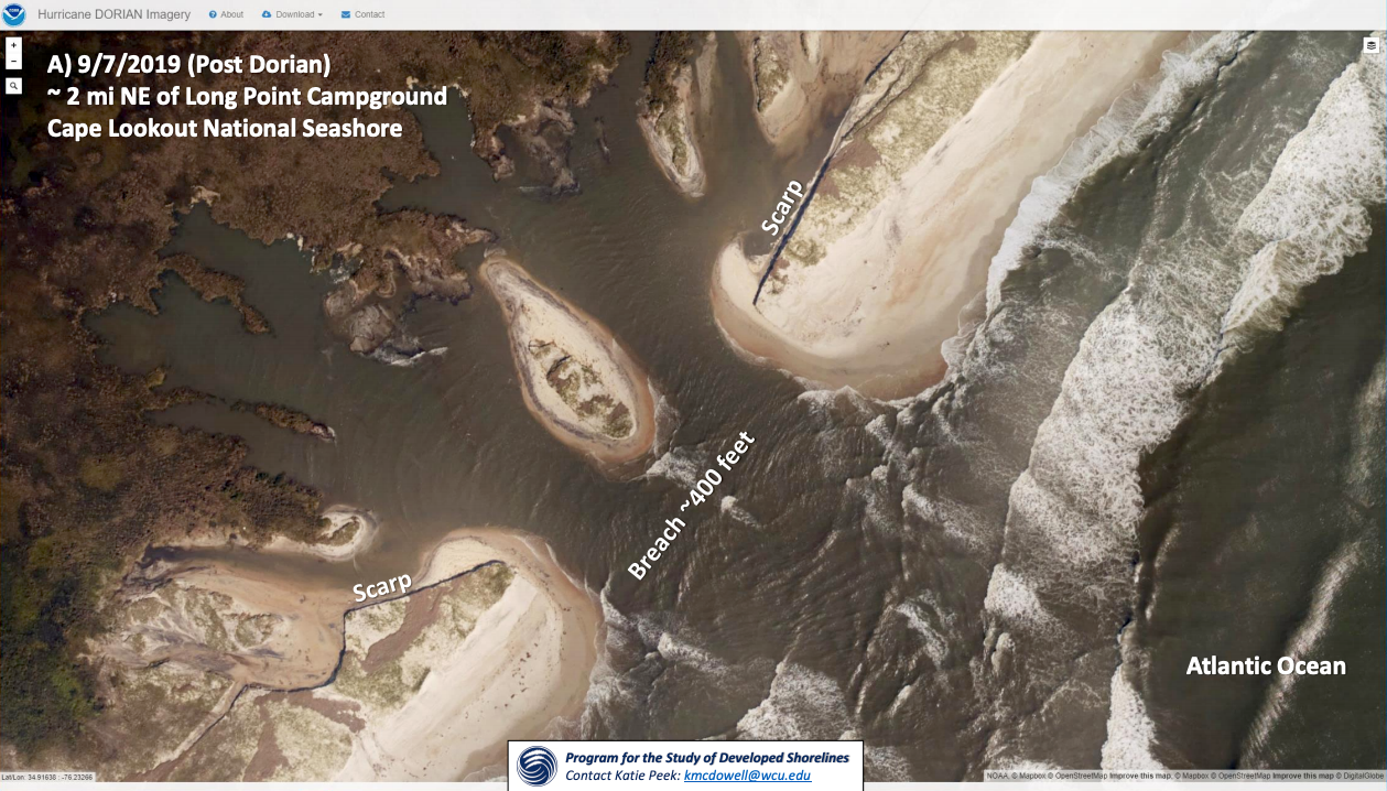
One of the larger breaches Dorian cut into Cape Lookout National Seashore/Western Carolina University
Though astonishing to have that many breaches from one storm, they come with ecological benefits.
"The water quality in Great South Bay on Long Island (between Fire Island National Seashore and the mainland) is the best that it’s been in decades since that inlet opened up," Professor Young said of the Otis Pike breach. "The baymen are having better luck with their fisheries. When you have a breach that forms like that, you get what we call a 'flood tidal delta' that will form behind the breach.
"Sand will come into the inlet, be transported back behind the island, and will form a small sand delta. And that delta will get colonized by marsh grasses, and over the long term it provides the sand and the structure that the island needs in order to respond to storms and sea level rise in the future. These are good things.”
This geologic turmoil has been ongoing forever.
"I think it’s important for people to keep in mind that these kinds of storm-driven changes have happened on barrier islands as long as we’ve had barrier islands," said Professor Young.
"Barrier islands are storm-adapted environments. The overwash that occurs during a storm, the creation of new inlets, inlets opening and closing, this is what barrier islands need to do," he said. "And the beauty of a national park is that we always hope that these are places where those natural processes can actually happen. We don’t have to stop them because it’s not a developed barrier island like Atlantic City, New Jersey, or Nags Head, North Carolina. It’s a place where the process can actually operate."
The processes can be critical to the natural environment. It's been demonstrated that overwash can scour and refreshen beaches in a way that benefits shorebird species, such as plovers. Beach grasses are adapted to these events, too, the professor noted.
For now, it's also a place where the Park Service needs to decide how to recover from Dorian. What gets put back in place, what doesn't?
“Most national seashores and national parks have to walk some balance, right, between the public use and the visitor access and infrastructure that is really outside of the park’s control. And NC 12 on the Outer Banks of North Carolina is a perfect example," said Professor Young. "It’s not up to the National Park Service to determine whether or not folks in the northern Outer Banks will continue to access Buxton and Hatteras Village on NC 12. The park has to do the best that they can to balance allowing those natural processes to continue with making sure that they are meeting the needs of the locality and the state for safety and evacuation. It’s a little bit of a complicated dance, but the Park Service does I think the very best job that they possible can.”
At Cape Lookout, part of the balancing will likely focus on how to restore Portsmouth Village and what to do with the cabins at North and South Core banks. Should they be rebuilt, or should the Park Service let the ocean win this particular battle?
“Those are the million-dollar questions, literally," said Chief Horvat. "We just fixed them from Florence, and now there are these inlets. So even if they were rebuilt, there’s nowhere for folks to drive anywhere any more. There’s two inlets on either end of the cabin camp. It’s almost like an archipelago right now. ... These are the things that we need to figure out."
And as there was a debate at Fire Island over whether to mechanically fill the breach in the wilderness area, there could be similar discussions at Cape Lookout with its many breaches.
“We’re part of the National Park Service, so our mission is to keep nature in an unimpaired state, and preserve it," said Chief Horvat when asked how the seashore might proceed. "So I don’t know. I know that if we go by our mission statement, then this is the new look of the park, I would say. There’s the politics around a lot of it too. And there’s movers and shakers that just want things. I don’t know. That’s one of the things that we’ll have to try to figure out in terms of moving forward.”
List to Professor Young discuss the impacts to Cape Lookout on National Parks Traveler's podcast.
Stories from recent past storms:
Rebuilding After Sandy: How The National Park Service Is Putting The Pieces Back Together Again
Rebuilding After Sandy: A Breach In The Wilderness At Fire Island National Seashore
Rebuilding After Sandy: Putting Gateway National Recreation Area Back Together Again
Rebuilding After Sandy: Moving The National Park Service Forward With An Eye On Climate Change
How Much Hurricane Relief Will Congress Provide The National Park Service?
Reader and listener donations help make stories such as this one possible. Please consider supporting journalism focused on national parks.
A copy of National Parks Traveler's financial statements may be obtained by sending a stamped, self-addressed envelope to: National Parks Traveler, P.O. Box 980452, Park City, Utah 84098. National Parks Traveler was formed in the state of Utah for the purpose of informing and educating about national parks and protected areas.
Residents of the following states may obtain a copy of our financial and additional information as stated below:
- Florida: A COPY OF THE OFFICIAL REGISTRATION AND FINANCIAL INFORMATION FOR NATIONAL PARKS TRAVELER, (REGISTRATION NO. CH 51659), MAY BE OBTAINED FROM THE DIVISION OF CONSUMER SERVICES BY CALLING 800-435-7352 OR VISITING THEIR WEBSITE WWW.FRESHFROMFLORIDA.COM. REGISTRATION DOES NOT IMPLY ENDORSEMENT, APPROVAL, OR RECOMMENDATION BY THE STATE.
- Georgia: A full and fair description of the programs and financial statement summary of National Parks Traveler is available upon request at the office and phone number indicated above.
- Maryland: Documents and information submitted under the Maryland Solicitations Act are also available, for the cost of postage and copies, from the Secretary of State, State House, Annapolis, MD 21401 (410-974-5534).
- North Carolina: Financial information about this organization and a copy of its license are available from the State Solicitation Licensing Branch at 888-830-4989 or 919-807-2214. The license is not an endorsement by the State.
- Pennsylvania: The official registration and financial information of National Parks Traveler may be obtained from the Pennsylvania Department of State by calling 800-732-0999. Registration does not imply endorsement.
- Virginia: Financial statements are available from the Virginia Department of Agriculture and Consumer Services, 102 Governor Street, Richmond, Virginia 23219.
- Washington: National Parks Traveler is registered with Washington State’s Charities Program as required by law and additional information is available by calling 800-332-4483 or visiting www.sos.wa.gov/charities, or on file at Charities Division, Office of the Secretary of State, State of Washington, Olympia, WA 98504.

Add comment