
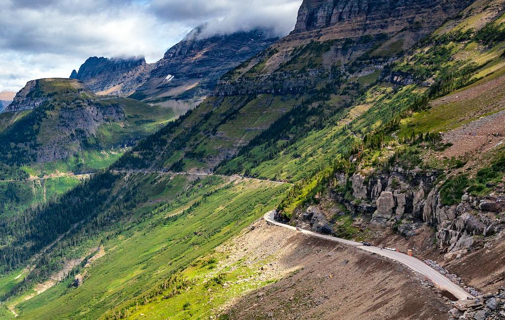
Trail Ridge Road in Rocky Mountain National Park is not for the faint-hearted....not until you park in the Alpine Visitor Center lot/Kurt Repanshek file
It's one thing to have your throat go dry and feel your fingers clench the steering wheel tighter than ever when you're driving Trail Ridge Road through Rocky Mountain National Park, but even my Honda Shadow seemed a bit reluctant to go higher and higher on the road towards the park's Alpine Visitor Center.
Those who have driven this 48-mile ribbon of pavement that somehow clings to the side of Trail Ridge with Forest Canyon far below can appreciate the queasy feeling in my stomach, owing, in no small measure, to the lack of guardrails protecting motorists from hurtling hundreds (thousands?) of feet down into the canyon. I initially sensed my motorcycle shared my concern, coughing and sputtering as it was, until I realized that we were climbing to 12,000 feet above sea level and the 700cc cycle's carburetor was growing desperate for oxygen.
Trail Road Road has to be experienced to be appreciated, if that's a good word for it, though many, after having driven the highest paved road in the United States, have sworn against ever doing it again.
Why are there no guardrails along the road? The Federal Highway Administration addressed that topic in the "barriers" section of the Trail Ridge Road Safety Study completed back in 2004:
Due to the steep slopes and rigid objects along most of the roadside, barrier is warranted along the majority of the roadway. However, there are several reasons why this is not recommended.
First, there are very few accidents occurring where guardrail or stone masonry wall would result in less injuries and property damage for the motorists. The crashes involving motorcycles would likely result in worse injuries if a barrier were in place. Outside of the alpine areas, vehicles that run off the roadway are generally stopped a short distance from the roadway by trees and due to the low speeds there are relatively minor injuries. If a barrier on this curvy road had redirected these vehicles, it is quite likely they would go across the other lane of traffic and possibly have a more serious accident or involve an innocent bystander in the crash.
With barriers on both sides of the road, they may ricochet back and forth across the lanes before coming to a stop. In the alpine section where the need appears greatest because of the sheer distance down the steep slopes, there are very few run-off-road accidents. This may be due in part to the extra care that drivers take due to the fear instilled by the sight of these slopes.
Second, the views from the roadway would be partially blocked by the barrier. Considering that the main purpose of this roadway is to provide tourists with the amazing vistas of this area, blocking views would take away from the very purpose of this road. This is not to say that blocking a view is more important than providing a safe roadway, but that installing barrier along both sides of the entire length of this roadway would not be worth the trade-off. (Trail Ridge Road was designated by the U.S. Secretary of Transportation as an All-American Road, the highest level of designation, in 1996. It is one of eleven America’s Byways® designated in Colorado).
Third, the cost and environmental impacts would be great. Because barrier by its very nature requires a wider roadway footprint, the cost of installing barrier on this narrow roadway would require retaining walls along most of the fill slopes. In addition, it was noted that many of the areas that most warrant barrier are areas that are already narrow with very steep slopes that extend for hundreds of feet.
Fair enough. And reason enough to make Trail Ridge Road perhaps the most precarious and most gut-clenching driving experience in the National Park System. But there are others that also shouldn't be taken lightly, good reader.
The Going-to-the-Sun Road is wonderfully scenic, and occasionally nerve-racking/Rebecca Latson
Going-to-the-Sun Road, Glacier National Park
This alpine experience was initially called the "Transmountain Highway." When 1933 rolled around and officials were ready to formally open the two-lane road to the public it was decided a more fitting name was necessary. So the road borrowed the name from nearby Going-to-the-Sun Mountain. According to local legend, the mountain got its name from a Blackfoot Indian legend in which a deity, Sour Spirit, came down from the mountain to teach braves the rudiments of hunting. On his way back to the mountaintop Sour Spirit had his image reproduced on the mountain to inspire Blackfeet.
It wasn't always clear that the Sun Road would follow its current 50-mile path between West Glacier and St. Mary. Early on there were debates over the best routing of a cross-park road. Some wanted it to run from Apgar to Many Glacier, others wanted it to run all the way to Waterton Lakes in British Columbia, and others were arguing for it to go by Gunsight Pass. In the end the U.S. Bureau of Public Roads (the precursor to today's Federal Highway Administration) decided the current route made the most sense. Once that decision was made, National Park Service landscape architects worked with Bureau of Public Roads engineers to, as much as possible, blend the road into the mountain environment.
The road's construction was a massive undertaking. Planners insisted that the bridges, retaining walls, and guardrails be made of native materials. The engineers resorted to using small explosive blasts to cut the road's path as they feared larger blasts would be more destructive to the landscape.
Yes, unlike Trail Ridge Road, the Sun Road has guardrails. But if you're behind the wheel as you weave higher and higher towards Logan Pass, they don't seem to offer much assurance.
Logan Pass, the apex of the Sun Road, is pinched tightly between Clements Mountain and the southern tip of the Garden Wall, a massive rib of rock that carries the Continental Divide through the park’s interior. From this saddle the pass sends Reynolds Creek and Logan Creek in opposite directions as their waters cascade down massive U-shaped valleys scooped out during the park’s glaciated past.
It can a dangerous road to traverse, with avalanche paths that can send mud and rocks down when there's no snow. That's what happened back in July 2012, when a muddy torrent stranded about ten vehicles and sent one individual to a hospital.
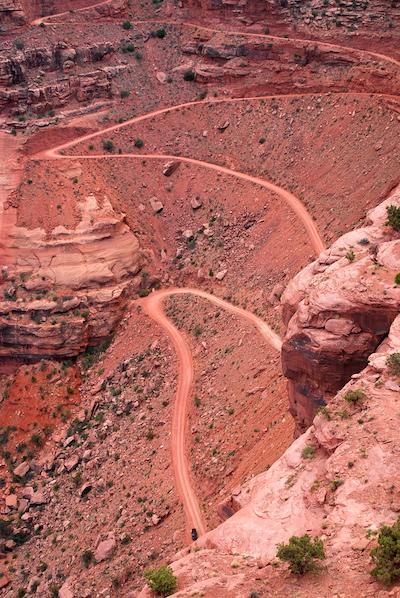
Descending the Shafer Trail Road catches your attention/Kurt Repanshek file
Shafer Trail Road To White Rim Road, Canyonlands National Park
Survive the first stretch of this dirt road and you'll do fine. Most likely.
That first stretch is the Shafer Trail, which quickly drops down from Red Sea Flat. You pass the Gooseneck Overlook of the Colorado River, and then Musselman Arch on the way to Lathrop Canyon and the White Rim Road. This is when your 100-mile adventure really begins as the dirt road wends its way below the Island in the Sky District of the park.
Many pedal their mountain bikes on a multi-day adventure through this stretch of Canyonlands, others make a four-wheel drive trek out of it. Here's what the park staff has to say about the route:
Under favorable weather conditions, the White Rim Road is moderately difficult for high-clearance, four-wheel-drive vehicles. The steep, exposed sections of the Shafer Trail, Lathrop Canyon Road, Murphy Hogback, Hardscrabble Hill, and the Mineral Bottom switchbacks make the White Rim loop a challenging mountain bike ride, and require extreme caution for both vehicles and bikes during periods of inclement weather. During high water conditions on the Green River, sections of road on the west side can flood, making a complete loop impossible.
Haleakala Highway, Haleakalā National Park
Not everyone was thrilled to see this not-quite 11-mile zigzagging road through the park to the summit of Haleakalā built.
"The Maui News reported that from the outset of the project, Hawaiians protested the building of the road on sacred Haleakalā. They believed that the gods would bring disaster to the project," the Park Service notes on its website for the park.
Rising a bit above 10,000 feet above sea level, wintry weather can close the road most any time of year. Back in April the road was closed on April 12 due to snowy weather.
"The road is well-maintained and well-traveled, but it's still a good idea to drive carefully and obey the speed limit signs. There are many switchbacks, blind turns and steep dropoffs without guardrails. Also, sometimes animals including cows and nene geese cross the highway," notes the To-Hawaii website.
So popular is viewing sunrise over the Pacific from the top of this road that you need a reservation to make the trek to the top between 3 a.m. and 7 a.m.
There are other routes in the park system that should be treated with no small measure of reverence.

Negotiating Elephant Hill in Canyonlands National Park requires skills and nerves/NPS, Neal Herbert
Elephant Hill, Canyonlands National Park
Elephant Hill just might be the gnarliest four-wheel-drive road in Canyonlands.
Located in the park's Needles District, the "road" is narrow, is precipitous in places, and will scare the wits out of passengers...and maybe even the driver. And yet, it is highly popular with the off-road-vehicle community. The Elephant Hill road is one of the most technical 4WD roads in Utah, according to the park. It presents drivers and mountain bikers with steep grades, loose rock, stair-step drops, tight turns, and tricky backing.
Racetrack Road, Death Valley National Park
Not for two-wheel-drive sedans, but rather 4WD or AWD, this narrow thread of road leads to the fabled land of moving rocks in the heart of Death Valley. You have scenery, the interesting photo op presented at Tea Kettle Junction, and the mysterious sliding rocks on the Racetrack. Just be prepared for mile-after-mile of washboard track that will jar your bones and chatter your teeth. I've driven this route twice, and what amazed me was the speed of some drivers in rented Jeeps.
Cove Creek Road, Great Smoky Mountains National Park
A dirt extension of the Cove Creek Road that leads you off U.S. 40 on the North Carolina side of Great Smoky and into the Cataloochee Valley races the park's northern border along the way to connecting with Tennessee 32. This is the quieter side of Great Smoky, yet it offers historic architecture much like that found in Cade's Cove. Incredibly scenic as this area is, the road is not designed for RVs, so best not to test it if you're trailering one or driving a bus-sized RV.
South Core Banks, Cape Lookout National Seashore
You won't find this road on your highway map, as it's simply a route through the sand dunes of South Core Banks. But it's a wonderful experience if you're comfortable driving on sand. This sand track runs the entire length of the island, with spurs leading to the ocean side. What's nice about this is it opens up the possibility of primitive camping settings, great birding, solitude, and, of course, the ocean! To drive on the sand, you'll want to reduce the pressure in your tires to about 20 psi for better traction. And, of course, once you're ready to board the ferry for the return to the mainland, you'll want to have an air pump to reinflate your tires.
No doubt there are other routes in the National Park System that catch your attention. Any nominees?


Comments
Check out the Mineral King Road in Sequoia National Park or, for that matter, the park's main road -- Generals Highway -- for some scream-for-your-mama views. Then hop on over to contiguous Kings Canyon National Park and take Highway 180 down into Kings Canyon proper where "dizzying" is an understatement.
As someone who has driven Trail Ridge Road in RMNP on a regular basis in order to get to work at Trail Ridge Store next to the Alpine Visitor Center, TRR doesn't bother me. The road is wide enough and one never feels like they're pinched in. In only one stretch does the road drop off on both sides, otherwise there's a hillside to your side. And even then once you're on top it's fairly gradual to the extent that a person can actually utilize the passing zones if they're in a hurry.
Now Going To the Sun Road, that road takes concentration and when driving a full size truck, I fold in the mirrors and hope I don't scratch the side on the rock wall yet giving enough room to oncoming traffic so as not to sideswipe the vehicles riding the center line. I'm more nervous about the more substantial drop on the other side of the retaining wall without anything to catch you.
If I remember correctly, Stevens Canyon Road in Mount Rainier NP was a little hair raising as well.
I've done Haleakala Highway, but it wasn't that bad. What does seem to get crazy is the bikes going completely downhill from the top. It's got so dangerous that commercial companies aren't allowed to bring anyone to the top in bikes any more. I heard that commercial tours can take customers to the top for the views, but if they wish to leave the bikes with the customers they have to exit the park and do it, where there's a lot of down outside of the park.
There are a ton of sharp drop offs in the Sierra.
It isn't actually in a national park, but Beartooth Pass between Redlodge, MT and Yellowstone NP is quite the drive. Steep, high, twisting, and very scenic.
If Trail Ridge Road and Going to the Sun are a 9 of 10 on scariness, the "Hogback" on Utah route 12 between Bryce and Capital Reef is a 12! Dropoffs on both sides!
Strangely enough, Muir Woods Road from Mill Valley is pretty hairy, especially heading back towards Mill Valley.
https://www.youtube.com/watch?v=8QwkpT2vQUg
And New Priest Grade (SR 120) is one of the more popular ways to get to Yosemite from the Bay ARea.
https://www.youtube.com/watch?v=iseh_muFdq8
Agree with you about Stevens Canyon Road. Drove it a number of times when I worked in the park in the early 90s and for the first time since then last summer, thinking "Wow, I don't remember it being this hairy!" I guess age really matters.
You nailed it about GTTS Road... "That road takes concentration".
I thought Glacier's Going To The Sun Road was more gripping than Trail Ridge Road in Rocky Mountain because of steeper, someimes cliffy slopes below and the threat of rockfall and even snow avalanches from above.
Those visitors who find either of those roads uncomfortable should definitely avoid Olympic's Obstruction Point Road, with even steeper large open slopes and a narrower gravel road bench. Plus, it's a dead end so you must drive it both ways. I once met a small motor home on the scariest portion that hugged the roadcut in the wrong 'lane' and forced me to squeeze by on the outside with only inches to spare.
Since several non-NPS roads have been mentioned, I'd like to add the eastern Yosemite access via Tioga pass from Lee Vining. My personal scariest road ever is the upper portion of Hart's Pass (another dead end) on the east side of the North Cascades Complex.