Yellowstone engineers have come up with a plan to replace the deteriorating Yellowstone River Bridge/NPS
Editor's note: This corrects location of the bridge to beween Tower Junction and the park's East Entrance.
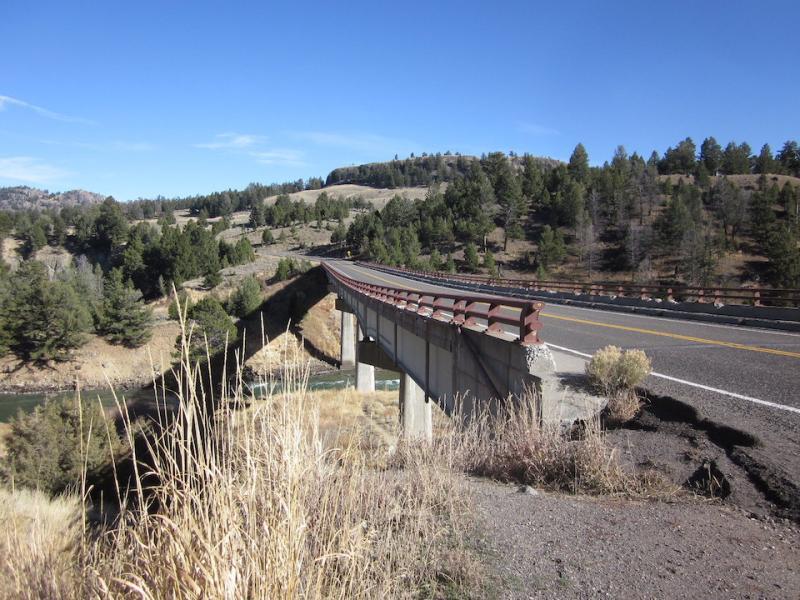
Severe winter weather, geothermal sources, and short construction seasons top the list of issues Yellowstone National Park managers encounter when planning major projects, such as replacement of the Yellowstone River Bridge between Tower Junction and the park's Northeast Entrance.
While replacing the bridge won't happen overnight -- it's expected to take three construction seasons -- park engineers believe they have come up with the appropriate plan, and your thoughts on it are welcomed.
While the plan calls for a bridge roughly twice as long as the existing structure, the intended route the engineers have selected would avoid wetlands currently impacted by the present road alignment and eliminate a hairpin curve, according to the park's environmental assessment.
The project is needed because current engineering assessments of the Yellowstone River Bridge say it is "seriously deficient or presents a safety hazard, but can remain in service at reduced loads or with frequent inspections."
The bridge is part of the only road corridor in the park that is open year-round and plowed in the winter. Built in the early 1960s, the concrete deck, sidewalks, and parapets have deteriorated. Under the park's preferred alternative, the new 1,200-foot-long bridge would be built across the river about 500 feet south of the existing bridge.
One mile of new road would be constructed to line up with the new bridge location. Following construction, the existing bridge and approximately 1.5 miles of existing road would be removed, and the area restored," the EA notes.
If approved, construction on the new bridge would begin in the summer or fall of 2022 and continue through 2024, depending on funding availability.
If the proposed project is implemented, construction delays would vary by alternative. This could range from no delays to up to 30 minutes with occasional two to four-hour delays. There may be temporary closures, including regular nighttime closures, depending on the alternative. The public would be notified of closures in advance if they occur.
Comments on the proposal are being taken through March 15. You can submit them online at this site, or deliver them to the park by hand or mail.
Hand-deliver comments during business hours to: Albright Visitor Center, Attention: Yellowstone River Bridge Replacement, Mammoth Hot Springs, Yellowstone National Park, Wyoming 82190.
Mail comments to: Compliance Office, Attention: Yellowstone River Bridge Replacement, P.O. Box 168, Yellowstone National Park, Wyoming 82190.
The park is also completing compliance with Section 106 of the National Historic Preservation Act for this project and is consulting with the Wyoming State Historic Preservation Office on the proposed design.


Comments
moving off wetlands: good idea
removing old roadway & restoring: good idea
minimizing delays: good idea
eliminating hairpin turn: good idea
I think you planned this well.
Is this bridge between Mammoth Hot Springs and Tower Junction? It appears that the bridge under discussion crosses over the Yellowstone River between Roosevelt and the Northeast Entrance, and one driving from Mammoth Hot Springs to Tower Junction would not cross it.
Good catch, anonymous. We've corrected the location.
Without checking my map, I'm going to say it's not between "Tower Junction and the park's East Entrance." I believe someone coming in the East Entrance would cross Fishing Bridge (which does cross the Yellowstone River, but is not the bridge under discussion) before getting to the loop road, and would then be near the Lake area and south of Canyon. I believe the route from the East Entrance to Fishing Bridge is where the Park uses ordnance to cause planned avalanches before opening the road each spring.
Someone coming in the Northeast Entrance would cross a bridge over the Yellowstone River just before getting to Roosevelt, and I believe that is the bridge with the hairpin curve and the road that is kept open all year.
Will, you're absolutely right. It's between Tower and the Northeast, not East, entrance.