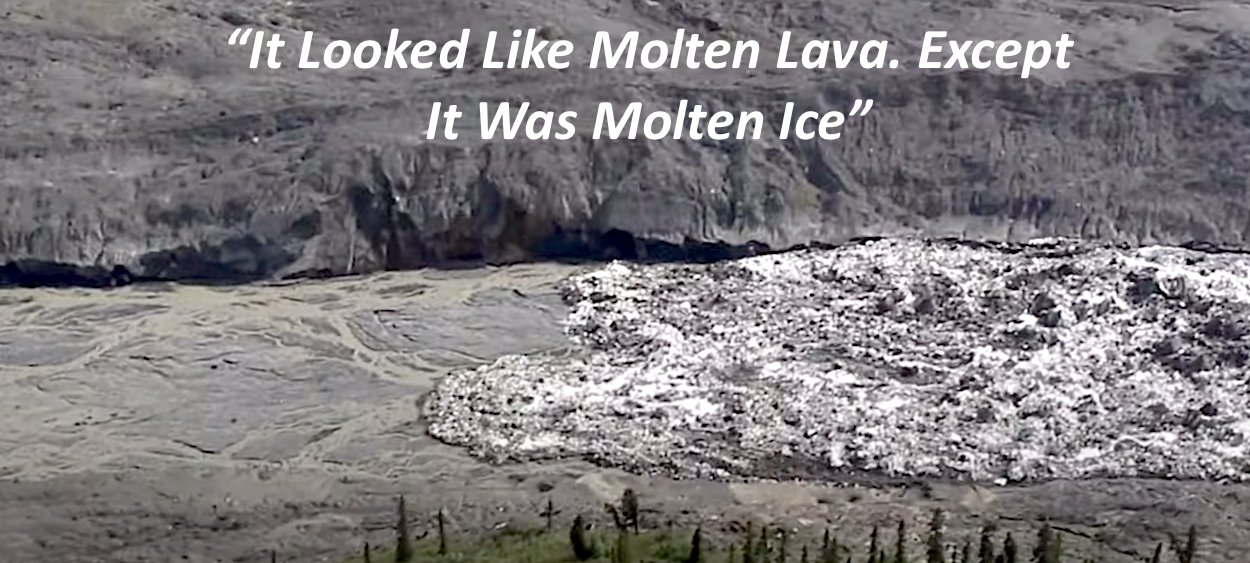
"My first impression was that it looked like molten lava. Except it was molten ice. It had that same kind if pyroclastic flow to it," recalled Peter Christian of the day back in 2016 when he flew over a remote corner of Wrangell-St. Elias National Park and Preserve and saw a slurry of ice coursing rapidly downhill through a barren drainage.
That unnamed drainage on Mount Sulzer, known locally as Flat Creek, was largely barren due to two events in the preceding three years that made the icy flow below Christian seem miniscule in comparison. No one witnessed the 2013 or 2015 events, but their flows stripped the drainage's mountainsides of stands of a centuries' old forest of white spruce, trees that in this harsh environment stand 30 or so feet tall on trunks about foot in diameter.
From floor of the drainage, the slurries of ice, mud, and rocks quickly filled the small valley and climbed more than 300 feet to overtop a hill. Through satellite imagery, it was determined that the larger 2015 flow also overran and eclipsed the footprint of a similar event in 2013. Combined, the two events swept away roughly 6.5 square kilometers (nearly 4 square miles) of forest, some of which was buried under 20 meters (~65 feet) of mud, muck, and ice.
But what caused these events? What triggered the detachment, or snapping off, of huge amounts of glacial ice and sediment that then swept 4,900 feet downhill from the glacier's crest to the valley floor?
The 2013 event was spurred by the breaking off of 244-395 million cubic feet of glacial ice, enough to fill about 4,000 Olympic swimming pools. Two years later, another 614-965 million cubic feet, which would fill about 7,200 Olympic pools, broke off and sped downhill along Flat Creek, taking several thousand acres of spruce forest with it.
The icy flow Christian, the park's chief ranger and backcountry pilot at the time, saw in 2016 was a relative afterthought compared to the previous two, but still an impressive display of nature's dynamism.
"What I can say confidently is that the overall mechanism of that 2016 event was similar (to the 2013 and 2015 events)," Dr. Michael Loso, Wrangell's geologist who counts glaciers among his specialties, told me. "You clearly had a buildup of water in or under or on top of, in the vicinity of the glacier, that then caused a chunk of the glacier to break off and the water and the ice to travel downhill."
But the collapses were not thought to be related to the surging forward of the glacier, or glacial melt typically tied to a warming climate, or an ice avalanche.
Wrangell-St. Elias National Park And Preserve: "A Jumbled Mass"
At more than 13 million acres, Wrangell is the largest unit of the National Park System, and arguably its most rugged, with mountains that reach 18,000 feet and a landscape that drops all the way to the Gulf of Alaska. More than 3,000 individual glaciers that drape the park's mountains combined contain more than 11,000 square miles of glaciated area. Those glaciers serve as the headwaters for many of Wrangell's streams and rivers.
North America's largest tidewater glacier, the Hubbard Glacier, creeps nearly 80 miles from Mount Logan in Canada's Yukon Territory to Disenchantment Bay in Wrangell. There, its six-mile wide face slowly calves into the water.
"Out of all the parks I’ve worked in in Alaska, it’s definitely the rawest," Christian told me. "Everywhere you go it looks like it’s still being formed. Glaciers are still carving things like in real time. Everything just looks like a jumbled mass."
Peter Christian and Luke Wassink were on a routine patrol of Wrangell's backcountry in August 2016 when they flew over the Flat Creek drainage.
“We were doing our regular hunting season law enforcement patrol, and I had Luke, one of our rangers in the backseat with me," Christian said last week. "We were just out doing a regular fly-by, always looking for archaeological sites, or anything on the ground because it’s such a great platform for looking at things.
“We were flying in a pretty remote part of Wrangell. This is a place where we almost never go to. It’s pretty close to the Canadian border, there’s nobody else around out there. It’s one of those places we might get to a couple times during the season if at all," the ranger continued. "I was just flying and looking at the horizon and my passenger, who could look all around, said, 'Hey, what’s that down there?' And I looked over my shoulder and down, and 'Holy cow, what is that?' And it was just like this wall of white…you couldn’t say it was water. White ice, just moving rapidly down this creekbed.
"It kind of reminded me of the tsunami at Fukushima when you could see the wall of water, it kind of looked like that," said Christian. "This wall of water. And then we realized it wasn’t water. It was almost like it was a wall of ice. And I just started circling while he dug in his backpack and got out his video camera and I thought, 'Wow, you better get this fast because it’s going to be over soon.' But it wasn’t, it just went on and on. We must have done 20 circles while he recorded it.
“I’ve never seen anything like that. It was kind of a once-in-a-lifetime thing.”
Christian, who now works in the Park Service's Alaska headquarters, said they looked up the drainage to the headwall where the glacier was.
"You could see where there was, or had been, an icefield or a glacier," he said. "It was obvious it had come from there. The whole front of the glacier had just disintegrated and started moving down the drainage. And it’s weird, my first impression was that it looked like molten lava. Except it was molten ice. It had that same kind if pyroclastic flow to it. So I kept waiting for the water to run out from under the ice, but it never did. It just stayed this sort of liquid ice."
It later was determined the icy slurry was moving downhill at about 25 mph. Christian could only imagine what might have happened if backpackers were crossing the drainage when the flow came down.
“It would be terrifying. It would be like any natural disaster that you get caught up in," he said. “I think we even said that as we were flying over, 'What if you were in there backpacking and you were crossing that creek when that thing let go?' You would be ground up pretty fast.”
 hike from their camp (located out of harms way, far above the valley) down to the deposits left by the Flat Creek glacier detachments along the valley bottom. The start of a nine hour day in the fi")
Matthias Leopold, Lia Lajoie, and Mylène Jacquemart (l-r) hike from their camp (located out of harm's way, far above the valley) down to the deposits left by the Flat Creek Glacier detachments along the valley bottom. The start of a nine-hour day in the field taking geophysical soundings of the ice-filled deposits, visually inspecting the ice exposed along stream cuts, and taking samples of sediment particle size/Ethan Welty
Fortuitous Eyes In The Sky
The events at Flat Creek might have gone unnoticed if not for Jeff Trop.
"He was doing some unrelated work, geology work, in that part of the park, and was flying to one of his field sites and flew over the debris pile. Basically flew over the valley where this had occurred," Loso explained. "It’s in a really remote place that very few people get to. He took some pictures because he thought, ‘Wow,that’s weird, I wonder what happened there?'"
When he returned from that July 2015 flight, Trop shared his photos with Loso. "I became curious, and I started asking around," the geologist said.
One of those Loso questioned was Tom Vaden, a long-time seasonal resident at Solo Creek that runs down Solo Mountain opposite Flat Creek and across the White River. He reported hearing a "large shock" from the Flat Creek area in mid-summer 2013. He said there was a similar event in July 2015, just three weeks after Trop snapped his photos during his overflight. Then Loso heard from an air taxi pilot who had taken photos of the area, and finally, in 2016, the geologist visited the area to see for himself.
"I got a chance to fly over and take some photos and get a much clearer sense, not of what happened ... but I got a clear sense of what the aftermath was," said Loso.
The geologist had seen enough to not just further pique his curiosity, but to call in additional researchers. One was Mylène Jacquemart, a Ph.D. student at the University of Colorado Boulder, who turned into a forensic geologist in an effort to understand what had happened at Flat Creek. Armed with satellite imagery, field measurements, digital elevation models, and meltwater modeling, the scientists slowly began to piece together just exactly what had happened.
To decipher what spurred the detachment, Jacquemart spent part of her time studying satellite images of the area.
"A lot of the detailed work related to (the 2013 event), Mylène did, and so I want to give her a lot of credit for this. It was mainly through analysis of satellite imagery and satellite-derived digital elevation models," said Loso. "None of the satellites that are up there were (specifically) tasked to look at the Flat Creek area. It’s pretty opportunistic to happen to capture footage at the right time, when there’s no clouds, right time relative to when the event occurred, what’s the quality of the imagery and all those sorts of things. So it wasn’t easy. But piecing together a bunch of historic satellite data was the main tool that we used to understand the change in surface elevations that occurred before and after those events.”

Lia Lajoie inspects an autonomous timelapse camera installed in 2019 to monitor the remains of Flat Creek Glacier and the valley headwall for any future detachments and other changes. Due to precautions taken because of COVID-19, it is still unknown when and whether National Park Service staff will be able to visit the cameras this year and collect the images they captured/Ethan Welty
That "change in surface elevations" involved a roughly 70-meter (230-foot) bulge in the glacier hugging the headwall at the top of the drainage. It was there in satellite images taken before the August 21, 2013 outburst, but not afterwards. Seeing that bulge, and then noticing it later was gone, was the key to understanding what happened that year, said Jacquemart.
Loso looked through seismic records to determine whether earthquakes might have spawned the detachments. What he found was while there were seismometer tracings that pointed to shaking earth on the dates of the 2013, 2015, and 2016 events, they all were related to the detachments, not quakes.
"We checked the USGS earthquake catalog and could not find any earthquakes big or close enough during that time to trigger something like this," Jacquemart told me. "Additionally, the seismic signals look very different from those that earthquakes produce, and instead have some of the typical features common for landslides."
What the researchers also were able to figure out was that the glacier had essentially been welded, or frozen, to the ground. That impeded the downward slide of the glacier, led to the resulting upward bulge, and prevented meltwater from flowing out, she said.
"To the surprise of a lot of people, because glaciers seem so cold, most glaciers that we’re familiar with, like in the Lower 48 or the Alps or what have you, are not frozen at their beds," explained Loso. "They’re at the freezing point, but there’s liquid water there. They’re able to slide because they’re not frozen to the ground, it’s not cold enough for them to freeze all the water and then actually adhere themselves to the ground by freezing.
"But some glaciers do do that, particularly, as you might imagine, in very cold places," he continued. "And also when the ice is fairly thin, that helps because the air temperature can more easily penetrate to the bed if the ice isn’t very thick. So the terminus, or the lower portion of the Flat Creek Glacier, we believe based on some different evidence, was frozen to the bed.”
Like a balloon that can only hold so much air, the buildup of subglacial water pressure eventually caused the glacier tongue to snap off in 2013, and then again in 2015.
Identifying Glacial Risks
The researchers could find only three other places in the world where there were "catastrophes of similar magnitude"; one in Russia, another in Tibet, and several glacial detachments at Iliamna, a volcano in Alaska's Cook Inlet.
The common denominator that appears to have driven those in Wrangell in 2013, again in 2015, and again in 2016, was unseasonally warm weather.
"It was one of the hottest summers on record in Wrangell," Christian recalled of 2016. "So you couldn’t help but wonder if those repeatedly hot days, day after day, just caused the collapse.”
That's the hypothesis Loso and Jacquemart arrived at, and has Jacquemart thinking that similar glacial detachments could become more frequent as the climate continues to warm. That poses a heightened risk to residents in some of the world's mountain communities, as those past detachments in Russia and Tibet killed many, she said. A detachment in 2002 of the Kolka Glacier in the Russian Caucasus killed more than 120 and wiped out their village, while the Tibetan event in 2016 involving two glaciers killed nine people and hundreds of herd animals.
A clearer understanding of the triggers for glacial detachments is needed so mountain communities in risk areas can assess the hazards hanging over them, Jacquemart said.
"We are not aware that this has happened anywhere else in the U.S.," she told me. "I think it is important to realize that we are still far from understanding these events in detail. In the case of the detachment in Tibet (which affected two neighboring glaciers), the second one was actually identified in advance (based on how the surface of the glacier evolved prior to the detachment)."
 hike back to camp after a nine hour day in the valley bottom investigating the deposits left by the Flat Creek glacier detachments. Flat Creek glacier (or what remains of it) is the left-most glaci")
Matthias Leopold, Mylène Jacquemart, and Lia Lajoie (l-r) hike back to camp after a nine-hour day in the valley bottom investigating the deposits left by the Flat Creek Glacier detachments. Flat Creek Glacier (or what remains of it) is the left-most glacier visible in the background/Ethan Welty
While there are parks in the Lower 48 with glaciers, places such as North Cascades National Park, Mount Rainier National Park, and Glacier National Park, Jacquemart doesn't see the glaciers in those parks at risk of such detachments.
"Our current understanding suggests that the process witnessed at Flat Creek Glacier was tightly connected to the fact that this glacier lies in a very cold region, and is therefore partly frozen to its bed," she said. "This is not the case in either Glacier, Mount Rainier or the North Cascades national parks. Therefore, the process we believe to have identified at Flat Creek is highly unlikely to occur in the three parks you mention."
In a 2019 paper that Jacquemart and Loso wrote for Alaska Park Science, Volume 18, Issue 1, the two reflected on the glacial detachments in Russia and Tibet and questioned how a warming climate would continue to affect glaciers.
"In both cases, the precipitating glacier collapse was later characterized by researchers as extraordinary and outside the normal boundaries of expected glacier behavior. Of course, this is a reflection, at least in part, of our incomplete understanding of glacier and debris-flow dynamics," they wrote. "Does it also mean that the worldwide trend toward accelerated glacier mass loss is accompanied by new and potentially more dangerous forms of retreat? In a national park with over 3,000 individual glaciers and a collective glaciated area of over 11,000 square miles, that question is an urgent one."
By Kurt Repanshek - May 3rd, 2020
Featured Article
Add comment

Support Journalism about National Parks!
National Parks Traveler is a 501(c)(3) nonprofit.
The Essential RVing Guide

The National Parks RVing Guide, aka the Essential RVing Guide To The National Parks, is the definitive guide for RVers seeking information on campgrounds in the National Park System where they can park their rigs. It's available for free for both iPhones and Android models.
This app is packed with RVing specific details on more than 250 campgrounds in more than 70 parks.
You'll also find stories about RVing in the parks, some tips if you've just recently turned into an RVer, and some planning suggestions. A bonus that wasn't in the previous eBook or PDF versions of this guide are feeds of Traveler content: you'll find our latest stories as well as our most recent podcasts just a click away.
So whether you have an iPhone or an Android, download this app and start exploring the campgrounds in the National Park System where you can park your rig.
Comments
Very interesting! Thanks for publishing this.