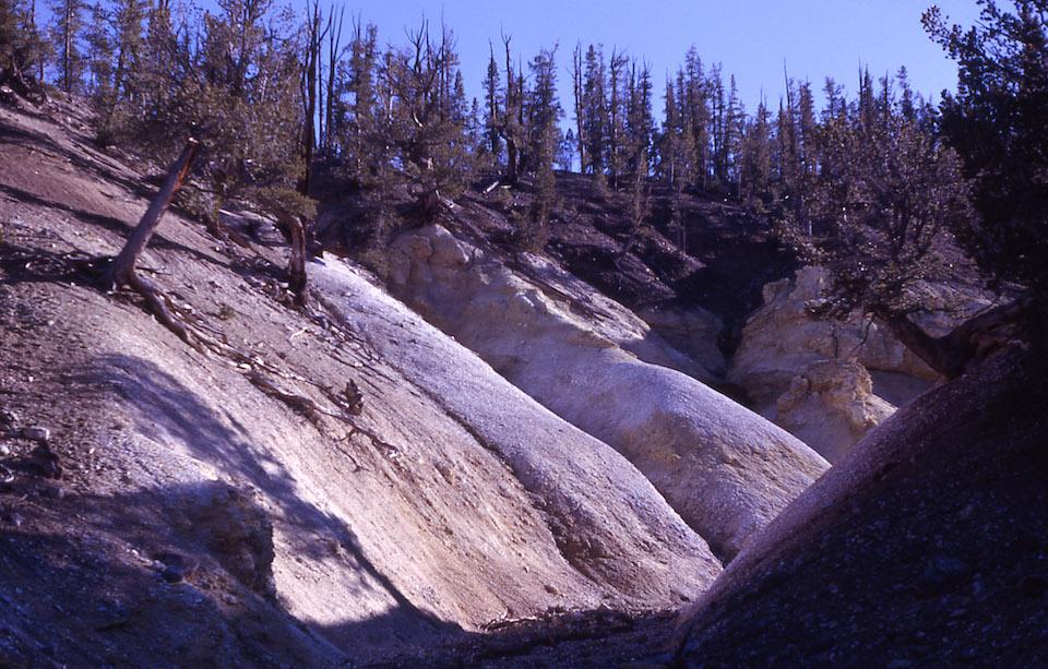
Death Gulch in Yellowstone National Park's northeastern corner has a deadly reputation/NPS, John Good
In the northeast corner of Yellowstone National Park, in Wyoming, is a ravine which is fully entitled to its grewsome (sic) name -- Death Gulch. It is a V-shaped trench, cut in the mountainside, and begins about 250 feet above Cache Creek. Apparently it forms a natural shelter for the beasts of the forest, as food, water and shelter are there, but entrance to the gulch means death to any animal, for the poisonous vapors that rise out of the ravine are more deadly than the bullets of the huntsmen, says the Laramie (Wyo.) correspondent of the New York Press. -- San Francisco Call, June 24, 1901.
Walk the thermal basins of Yellowstone National Park and it wouldn't be unusual to consider the wispy tendrils that drift above geysers and hot springs as nothing more than steam. And most are just that. But there are toxic gases emitted from the park's underlying volcano, too, as that 1901 dispatch above underscores.
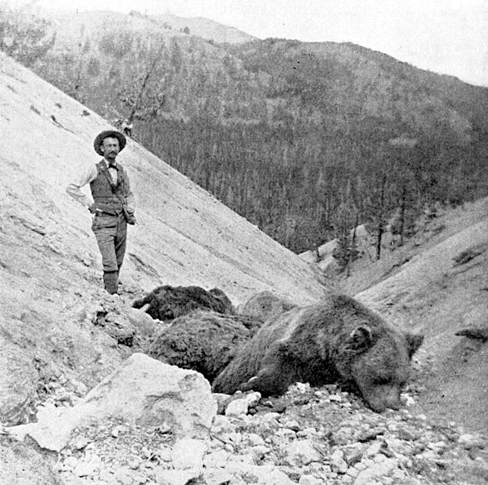
The article recounted the discovery of scores of animals -- grizzlies, elk, rabbits, and squirrels -- in the gulch by visitors who had come to try to determine what delivered the death sentences. Those investigators detected both carbon dioxide and a heavy, pungent smell of sulphur in that part of the upper Lamar River valley.
For ages this death trap in the Rocky Mountains has probably been luring the inhabitants of the forest to their doom. With the rains of spring the bones of the dead of the preceding year are carried down to the creek and the gulch cleared for the death harvest of the summer and the winter.
What impressed the visitors most outside of the horror of the gulch was the danger to visitors who might unconsciously enter the gulch. There was no difference in the appearance of the gulch from other gulches above and below the mountains, and there was nothing to warn a camper. For man to enter death gulch to camp means that he has camped in eternity.
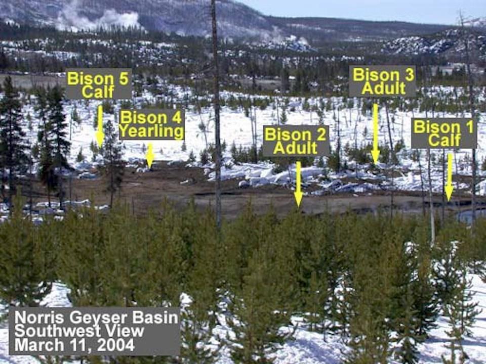
More recently, in March 2004, park bear management biologists came upon the carcasses of five bison in the Norris Geyser Basin, a mix of young and adult animals that appeared to "have died very rapidly, as a group." In searching for the death blow, biologists discovered high concentrations of both hydrogen sulfide (H2S) and carbon dioxide (CO2) gases in the area.

Location of bison killed by toxic gases in Norris Geyser Basin in March 2004/NPS
In the case of H2S, some concentrations in the Norris basin were measured above 200 parts per million, or more than twice the level that can kill a person under prolonged exposure. There also were air samples taken that were more than 20 percent CO2, also roughly twice the amount that can kill you.
Because H2S is heavier than air, it tends to settle in depressions or, in the case of Death Gulch, at the bottom of ravines. CO2 also can sink into topographically low areas. As a result, on calm days with little or no breeze, the gases can concentrate in lethal levels.
"Therefore, it is possible that the 5 bison were asphyxiated by CO2 and/or H2S gases on a cold night with still air in early March," was the conclusion drawn by Yellowstone's biologists.
Understanding Yellowstone's Gaseous Side
Such incidents raise the question of how common are such concentrations of toxic gases in the park that draws more than 4 million visitors a year? Unlike most volcanoes, which spit out their toxic gases near the summit, the volcano that is "Yellowstone" is mostly flat; there is no "top" through which to vent gases. Instead, gases waft up from throughout the national park's thermal basins.

A grizzly succumbed to Death Gulch's gases in 1897/Public domain
"Where is the top of the volcano at Yellowstone? There isn't one," Dr. Michael Poland, a research geophysicist who is the science-in-charge of the Yellowstone Volcano Observatory, told Traveler's Lynn Riddick in a podcast on the observatory.
"There's gas coming out of the entire park, just about. And so it's really hard to monitor gases at Yellowstone," he continued. "You would have to have continuous stations, which are still kind of a new technological development. Continuous gas monitoring has not been around that long. You would need to have them all over the place. And that's just not logistically viable. It's not financially viable."
Near the top of Poland's wish list is funding to enable such monitoring, as it could indicate how gases are released and possibly identify the drivers involved.
"We're measuring earthquake activity and ground deformation and river systems on a minute-by-minute basis, second-by-second in some cases. We're not measuring gases that way," he said.
Jefferson Hungerford, Yellowstone's staff geologist, agreed that a better gas monitoring system would be valuable as "another tool that we used to monitor the volcano."
Better gas measurements could help researchers discern whether the earthquake swarms that routinely roll across the park release more gases, and how subsidence affects the release of gases. It also could provide "hints about possible changes in the depth of magma beneath the surface," according to the U.S. Geological Survey.
"Measuring the rate at which CO2 is emitted from the volcanic system, its abundance relative to other gases and how these factors change over time can provide early warnings of when magma enters the earth’s deep crust and its subsequent movement upwards toward the surface," noted a November 2019 publication from the Yellowstone Volcanic Observatory.
"The reason we have a park is because of all those beautiful hydrothermal features," Hungerford said the other day during a phone call. "All those gases are kind of being scrubbed by meteoric water that’s working into the heat source and then mixing with some brines down there. The gas source coming off the geothermal system here is kind of muted. It’s not like we were sitting on Kīlauea Volcano (at Hawai'i Volcanoes National Park), sitting in the plume coming out of the vent there.
“Looking at those gases, and looking at some of the isotopes, we could probably get a better idea if we had better coverage of what was going on down below us," the geologist said. “It’s a big volcanic system.”
A better understanding of the H2S and CO2 gases, as well as other gases present in the system -- helium, nitrogen, oxygen, methane, ammonia and other trace gases -- could lead to a better understanding of Yellowstone's subterranean volcanics, he said.
"I really think that we should have more gas monitoring. Gas monitoring Yellowstone is really hard because anyone that's been to Yellowstone can tell you, you can't sort of go around the corner without coming across the thermal area," said Poland.
Hungerford said he'd like to see more monitors in the Norris Geyser Basin, the park's hottest and most dynamic basin, as well as in some other thermal areas.
"It’s a great tool, and when we see tons per day of CO2 kick up, if we can pinpoint it in a particular area, we know something’s going on," he said. "We can use that data to look at our seismic data and our GPS data and we can also look at thermal data to see if there’s something actually happened right in that area. It’s one of those great tools that we can use. But again, we have fiscal constraints.”
Geologic Murmurings
In spite of Yellowstone's reputation as a volcanic zone, most of the geologic activity actually goes unnoticed by visitors. The park's typical earthquake, said Poland, is the one that isn't felt.
"They're a magnitude 1 or 2, less than 1. So they’re very small. There are occasionally 'felt' events in the magnitude 3 or 4 range, there's typically a few a year," he said. "And occasionally you'll have a swarm of events that's large enough to have several felt earthquakes. A good example of that was in the latter part of 2017. Between June and September of 2017 we had a swarm of earthquakes that included 2,400 located events, and there were a few of that were in the magnitude 4 and 3 range that were felt. And that was only the second largest swarm. The biggest swarm was back in 1985.
"There were more events that went through a longer period of time. And this is sort of typical of Yellowstone. It's a very ‘swarmy’ place," Poland went on. "We see earthquake swarms all the time, typically every month has at least a few earthquake swarms, and May had four, one of which was right at the end of the month. And I think there were about 100 events in that late-May swarm. That's sort of typical for Yellowstone. That's kind of how it works. But the vast majority of these are not felt."
Despite the reputation of Death Gulch, and the March 2004 incident where the five bison died at Norris, Hungerford said the average park visitor doesn't need to be worried about Yellowstone's gases. But he also points out that more visitors have been killed by falling into the park's hydrothermal features than by bears.
“My good friend Kerry Gunther (Yellowstone's bear biolgist) is always reminding me, 'Jeff, the score is 21-8,'" Hungerford said. "These areas are so dangerous. We’ve lost more people (21) to these thermal features than we have to bears (8) in the park, which is pretty amazing.”


Comments
so interesting! thank you!