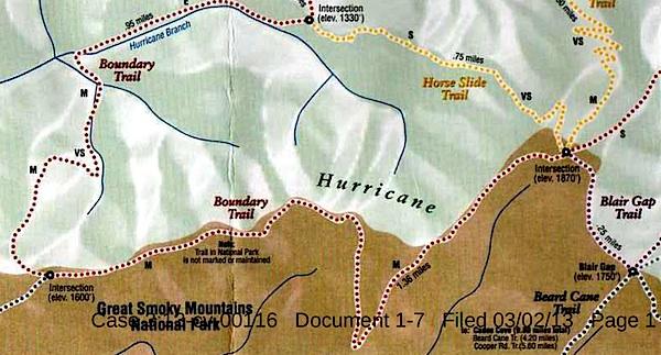
This map, said to have come from Blackberry Farm Resort, shows two trails -- the Boundary Trail and the Blair Gap Trail -- that are not listed on Great Smoky Mountains National Park's official trail map/Southern Forest Watch
Sometime in recent years two trails running more than a mile-and-a-half were cut into the backcountry of Great Smoky Mountains National Park, allegedly for the use of a private resort that borders the park, according to court documents.
When contacted by the Traveler, park officials declined to discuss the trails, or even acknowledge their existence, as their presence has been raised in litigation. However, the "Boundary Trail" and "Blair Gap Trail" depicted on a trail map purportedly handed out by the Blackberry Farm Resort do not match any trails on the park's official trail map. Together they run along the park's western boundary roughly from the Beard Cane Trail to the Cane Creek Trail. Officials at the resort, where rooms start at $745 a night, had no immediate comment when asked about the trails this week.
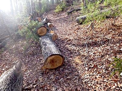
A trail of downed trees allegedly marked an illegal trail cut in Great Smoky Mountains National Park/Southern Forest Watch
The existence of the trails surfaced in connection with a lawsuit brought against the Park Service by Southern Forest Watch, a nonprofit group organized to overturn the park's $4 per night fee charged on backcountry travelers. Though not central to the fight over the backcountry reservation system, the group pointed to the "illegal trail system" as part of a pattern of "political patronage" that former park Superintendent Dale Ditmanson oversaw. Mr. Ditmanson, who instituted the backcountry fee system in 2013, retired from the Park Service earlier this year.
By allowing the Blackberry Farm Resort to maintain these trails for the use of their customers and residents, Great Smoky Mountains officials were limiting the general public's access to the park's backcountry and allowing it to be impaired, charges Southern Forest Watch's lawsuit.
The Park Service, in court documents responding to Southern Forest Watch's complaint, denied allowing a "private resort to maintain and utilize their own separate, exclusive network of trails into, on and within the boundaries" of the park. However the agency did admit that there was a signpost with a map box located outside the park boundary and that "any signs that were erected within Park boundaries by Blackberry Farm Resort were erected without permission from NPS and have since been removed."
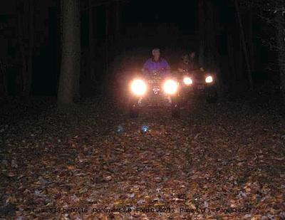
These ATVers allegedly were entering Great Smoky Mountains National Park from the Cane Creek Trailhead/Southern Forest Watch
The trail map showing the Boundary and Blair Gap trails came from the map box on the signpost, according to Southern Forest Watch's lawyer.
The trail signs and maps were found by John Quillen, a member of Southern Forest Watch. A park volunteer who regularly hikes the Cane Creek Trail to help maintain it, Mr. Quillen discovered the Boundary Trail in 2009 when he came upon a trail of trees that had been chainsawed down. He and some friends also heard a chainsaw at work, and encountered riders on two all-terrain vehicles who allegedly claimed they had come from Blackberry Farm. Photos of a trail sign, the ATV, and downed trees are part of Southern Forest Watch's court filing.
No court date for the matter has been set.


Comments
Ok, this is for the "NPS Can do no wrong club". I have broken it down for you with evidence. http://www.southernhighlanders.com/clayton_jordan.html
In the first arrow is proof that a ranger saw the trail system.
In bullet point number two is proof that in 2012 the same ranger was dispatched to the area and claims that "there appeared to be no evidence of continued clearing of the abandoned trail". The clearly contradicts the assertions by the reporter in the story from WATE in Knoxville and is patently false. The trail has clearly still been cleared by the resort (just look at the video clip above) , I have seen it myself along with dozens of others, just go up there if you don't believe me. The Ranger or Ditmanson was not telling the truth.
Then in bullet point number 3, they send another ranger who determines that "one of the trail signs is just within park boundaries". If you refer to the story above, you will clearly see from the video where the reporter is standing, that the trails behind her are WAAAAY within NPS bounds. The NPS is trying to cover their tracks.
There is one more thing in that lawsuit that may rattle your cages as well. Proof that the NPS GAVE LAND to former Tn Governor Don Sundquist who owns a house on NPS boundary. They illegally re routed a trail away from his house so he wouldn't be troubled by low life hikers and backpackers. They also closed backcountry sites near his house for the same reason. Here is the lawsuit with the details:
http://ftpcontent.worldnow.com/wate/news/backcountry-fees-suit.pdf
Again smokies - your arrows do not indicate that Ditmanson knew anything before 2012.
I see allegations not proof.
EC, this is pulled directly from the Southern Forest Watch lawsuit: The lawsuit may be found here and this is from page 18.
http://ftpcontent.worldnow.com/wate/news/backcountry-fees-suit.pdf
66. Ace Gap Trail is a backcountry trail that has existed within the Great
Smoky Mountains National Park for decades. The trail’s location has existed for
decades. Attached is a map from the Blount County Property Assessor’s office, which
appears to reflect, among other things, that Ace Gap Trail encroached on tract “1.13”.
That tract is 20.33 acres. The map is attached hereto as Exhibit F.
67. In 2004, a third party/former politician acquired tract 1.13, and soon
thereafter, defendants or defendants’ predecessors voluntarily and illegally diverted and
rerouted Ace Gap Trail off of tract 1.13, further back into the park away from the third
party/former politician’s new home.
Also, EC, this further explains the situation. It is also on page 18 of the lawsuit.
68. At the very least, that property became property of the Great Smoky
Mountains National Park by eminent domain decades before the third party/former
politician even acquired the property in 2004.
69. Defendants also closed at least two separate campsites that were apparently
too close to the third party/former politician’s property.
Are you quoting from the allegations from one side of a lawsuit and terming them settled facts?
Rick,
The lawsuit is still in the courts. I was asked to present evidence which is exactly what I have done. SFW presented these items as evidence and the judge will decide. Guess what the NPS has presented as "facts" or evidence to refute SFW's assertions? Nothing. Aboslutely nothing. Because they have nothing to present. Is the NPS denying the land swap? Nope. Is the NPS denying the Blackberry Farm trail system? To the contrary, they admit it. So you can "say it ain't so, Joe" all you want to. I realize that it is difficult to admit that the beloved agency is capable of such political patronage. It took me a while to wake up and realize the extent to which these bureaucrats would break laws for their political buddes. But it has been proven with this trail system and will be proven with the land swap. You present me evidence to prove that it didn't happen and we can have a healthy debate, Rick.